
Elevation 14,286 ft (4,354 m) Type of rock Granite | Length 40 mi (64 km) NS Age of rock Cretaceous – Paleogene | |
 | ||
Mountains | ||
Running at 14 000 feet central colorado mosquito range
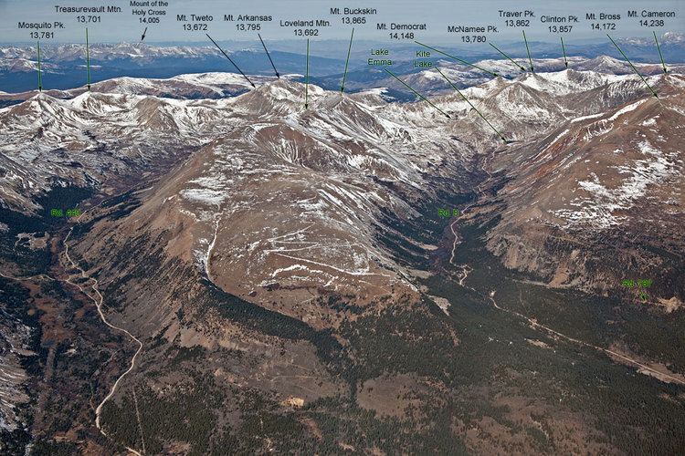
The Mosquito Range (elevation approximately 14,000 ft) is a high mountain range in the Rocky Mountains of central Colorado in the United States. The peaks of the range form a ridge running north-south for approximately 40 miles (64 km) from southern Summit County on the north end, then along the boundary between Lake and Park counties. The ranges forms a high barrier separating the headwaters of the Arkansas River near Leadville from South Park and the headwaters of the South Platte River near Fairplay. The highest peak in the range is Mount Lincoln at an elevation of 14,286 ft. Other fourteeners in the range are Mount Bross (14,172 ft), Mount Democrat (14,148 ft), and Mount Sherman (14,036 ft).
Contents
Hiking mosquito range
GeologyEdit
The mountains are faulted anticlines formed as part of the Sawatch Uplift during the Laramide orogeny approximately 65 MYA. The mountains were originally contiguous with the higher Sawatch Range to the west but were separated during the formation of the rift valley at the headwaters of the Arkansas River approximately 35 MYA. The range is primarily of granite. The eastern flank of the range along the rim of South Park overlain by Paleozoic and Mesozoic sedimentary rocks. The northern end of the range was glaciated during Pleistocene time, forming u-shaped valleys in the canyons.
The high ridge of the range forms a relatively difficult barrier between South Park and the Arkansas headwaters. Several of the high peaks of the range are prominently visible from the southern side of Fremont Pass along State Highway 91 between Climax and Leadville. The range is not traversed by any major highway, but only in two places by backroads over high passes: Mosquito Pass and Weston Pass. Much of the range is located within the Pike National Forest.