
Population (2014) 3,239 Area 71.04 km² | Canton Modane Time zone CET (UTC+1) Local time Wednesday 7:55 AM | |
 | ||
Weather 6°C, Wind E at 3 km/h, 50% Humidity Points of interest Fort du Replaton, Col de Chavière, Ouvrage Arrondaz, Ouvrage Pas du Roc, La Maison Penchée | ||
Modane ([mɔ.dan]; Italian: Modana) is a commune in the Savoie department in the Auvergne-Rhône-Alpes region in southeastern France.
Contents
- Map of Modane France
- Location
- Neighbouring communes
- Roads
- Railway
- Urbanism
- Toponymy
- History
- Political trends and outcomes
- Twinning
- Demography
- Education
- Business and shops
- Tourism
- Sport
- Places and monuments
- Museums
- Personalities linked to the commune
- References
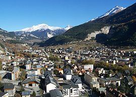
Map of Modane, France
The commune is in the Maurienne Valley, and it also belongs to the Vanoise National Park. It was part of the Kingdom of Sardinia until the Treaty of Turin in 1860.
Location
The commune of Modane is located in the Alps in the department of Savoie between the Vanoise massif to the north and between the Massif du Mont-Cenis and the Massif des Cerces to the south. Crossed by the Arc river, it extends to the doors of the Haute-Maurienne. The issue of the attachment or not of Modane in the Maurienne Valley or Haute-Maurienne differs depending on the disciplines of economics, geography or geology. For economists, Modane is attached to Haute Maurienne, arguing that the city has a very strong influence on the villages of Haute Maurienne, through economic and administrative infrastructure such as shopping centres, schools or the railway station for example. However, for the great majority of analysts, Modane is a commune attached to the middle part of this valley, both by the relief (encompassing the whole canton is a dug coal-bearing furrow which extends to Saint-Michel-de-Maurienne), and by the industrial history of this sector.
With an area of 7,104 acres (2,875 ha) [28.74 square kilometres (11.10 sq mi)], the commune extends along a north-south axis on both sides of the valley. To the north, Modane is bounded by the Roc des Saints Pères, and the Aiguille de Péclet (northwest) and the Dôme de Polset (northeast). To the south, also from west to east, these are the Refuge du Mont-Thabor (marking the boundary with the department of Hautes-Alpes), the Cime de la Planette, the Pointe du Fréjus and the Cime du Grand Vallon (marking the boundary with Italy) which delimit the neighbouring communes of Modane and Italy.
The Modane territory extends in a particular form. Indeed, a relatively short east-west width on the north side of the valley (a few hundred meters to a maximum of 5 kilometres (3.1 mi) between the peaks), is much larger on the south side (about 2 to 8 kilometres (1.2 to 5.0 mi) from the South shore of the CRA to peaks). From north to south, the municipality extends however over a length of around 15 kilometres (9.3 mi).
In Vanoise, the town is dominated by the Dent Parrachée at 3,697 metres (12,129 ft), the Pointe de l'Échelle at 3,427 metres (11,243 ft), the Rateau d'Aussois at 3,117 metres (10,226 ft), the Aiguille Doran at 3,039 metres (9,970 ft), the Dôme de Polset at 3,566 metres (11,699 ft) or the Pointe Rénod at 3,374 metres (11,070 ft). To the south stand the Pointe de Longecôte at 3,100 metres (10,200 ft), the Aiguille de Scolette at 3,508 metres (11,509 ft), the Belle Plinier at 3,076 metres (10,092 ft), the Pointe d’Arrondaz at 2,937 metres (9,636 ft) and also the Pointe du Fréjus at 2,934 metres (9,626 ft).
These peaks, however, leave easy passages, particularly frequented during summer by hiking tourists, either to the Tarentaise Valley or to Italy. In addition, some welcome ski resorts located within walking distance of the town, among which are Aussois, La Norma and Valfréjus.
Neighbouring communes
The commune of Modane is bordered by nine other communes in France, besides its southern limit marked by the Franco-Italian border. To the west, Modane mainly borders Saint-André and Fourneaux, but also to the south-west, Freney, Orelle, and Névache in the neighbouring department of Hautes-Alpes. To the north, in the Vanoise National Park, the bordering communes are Saint-Martin-de-Belleville to the north-west, with Les Allues and Pralognan-la-Vanoise to the north-east. To the east lies Villarodin-Bourget, with Avrieux to the south-east.
Roads
The commune is at the French end of the Fréjus Road Tunnel, one of the major transalpine road crossings along with the Mont Blanc Tunnel, linking France and Italy. Out of the tunnel, the A43 autoroute begins and which leads to Chambéry and Lyon, also passes on the heights of the commune (in Charmaix).
In addition, the D 1006 (former Route Nationale 6), an important route coming from Chambéry, also passes through Modane before continuing up to the Col du Mont-Cenis and the Italian border. The road is also the main axis of the commune, which it crosses through the full length of the centre. However, it has several street names including, from west to east: Avenue de la Liberté, Rue de la République, Avenue Jean Jaurès and the Cours Aristide Briand.
Railway
The commune of Modane is home to an international railway station, the Gare de Modane, in which receives trains from Turin in Italy, through the Fréjus Rail Tunnel, and with trains to Chambéry, as well as the TGV on the Milan (Italy) to Paris route. The whole of the French part of the line is owned by the Réseau Ferré de France (RFF), the upstream network is managed by Rete Ferroviaria Italiana, society of FS (Ferrovie dello Stato), the lower part and the station being under the management of the SNCF. There is therefore an electrical disconnection and signaling changes upstream (catenary supports also bear inscriptions in Italian).
The railway line serving Modane is the Maurienne line, or its official name the ligne de Culoz à Modane (frontière) [line of Culoz to Modane (border)]. It marks the territory of the commune of Modane looping 180° between its exit from the station and its entry into the Fréjus tunnel.
Urbanism
Toponymy
The modern spelling Modane is not attested before circa. 1700. Previously, there were Amoudane, Amaudane, Amaldanus. The initial vowel has therefore fallen from use (taken for the preposition à [to]). The word could come from a proper name, that of the keeper of a manso, Amaudanes, mentioned in a cartulary of the 12th century.
History
In 1871, following the opening of the Mont-Cenis rail tunnel Modane quickly became a border city. The Italian journey began between Italian immigration and transit trade and the population increased significantly. However, the increasingly strained relations between France and Italy lead to the construction in 1885 of the Fort du Replaton, an interdiction fort to monitor the entrance of the tunnel.
During World War II, the city was bombed on 13 or 17 September 1943 by Allied aircraft. The objective of the bombing was the station, an important centre of transit between France and Italy. The bombing caused 60 victims and 100 houses were destroyed. A second bombing took place on the night of 10–11 November 1943, killing five civilians.
In 1969, the city turned to tourism. A chairlift departing from Fourneuax and joining the hamlet of Charmaix on the commune of Modane, at 1,550 metres (5,090 ft) altitude, was indeed created, like the d'Arrondaz snow stadium, allowing skiing at 1,550 to 2,500 metres (5,090 to 8,200 ft) altitude.
In 1983, the promoter of Tignes, Pierre Schnebelen, created a new station from d'Arrondaz. It built the estate on the hamlet, two cable cars of 1,550 to 2,737 metres (5,085 to 8,980 ft), joining the top of Punta Bagna. A new international ski resort was created: Valfréjus (station attached to the municipality of Modane). Between 1983 and 2008, the station evolved to have 7,000 tourist beds.
Political trends and outcomes
2014 municipal elections in Savoie
Twinning
Modane is twinned with:
Demography
In 2012, the commune had 3,345 inhabitants. The evolution of the number of inhabitants is known through the population censuses carried out in the town since 1793. From the 21st century, communes with less 10,000 population have real censuses held every five years, unlike other communes that have a sample survey each year.
Education
Daycare:
Schools:
Collège: La Vanoise Collège
Business and shops
Tourism
In 2014, the capacity of the commune, estimated by the organisation of Savoie Mont Blanc, is 7,849 tourist beds in 870 establishments. Valfréjus ski station concentrates most of these beds and structures (over 70%). The accommodation of the commune is as follows: 139 furnished; 8 apartment hotels; 5 hotels; an outdoors facility; one holiday village and one gîte or overnight gîte.
Sport
The Tour de France cycling race came to Modane, starting stage 19 there, in 2011. Modane is due to welcome the return of the race during the 2015 Tour de France, for the start of stage 20, the penultimate stage, on 25 July.