
Length 40.6 km | Constructed 1928 | |
 | ||
County Mercer County, Pennsylvania | ||
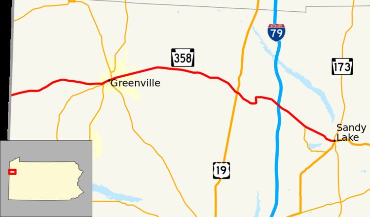
Pennsylvania Route 358 (PA 358) is located in Western Pennsylvania, running from the Ohio state line 6 miles (9.7 km) west of Greenville to Sandy Lake in Mercer County.
Contents
Map of PA-358, Pennsylvania, USA
Route description
Heading east from the Ohio state line in Mercer County, PA 358 travels through the village of Maysville about 3.4 miles (5.5 km) from the state line. Next the route enters the borough of Greenville about 3.3 miles (5.3 km) later, and intersects with PA Route 18, which joins PA 358 through the borough about 0.5 miles (0.80 km). East of downtown, PA Route 58 joins the concurrency for 0.3 miles (0.48 km), and then both PA 18 and PA 58 leave PA 358. The route continues out of Greenville, and passes near the village of Hadley about 7.8 miles (12.6 km) later, and then intersects with US 19 about 1.5 miles (2.4 km) after that. About 2.3 miles (3.7 km) later, the route passes through the village of Clarks Mills, and then interchanges with I-79 1.4 miles (2.3 km) later. PA 358 continues 2.4 miles (3.9 km), where it intersects with the north terminus of PA Route 845 north of Stoneboro, and then the route terminates another 2.3 miles (3.7 km) later in the borough of Sandy Lake at the north terminus of the US 62/PA 173 concurrency.
History
In 1928, PA 358 was originally signed from the Ohio state line to Greenville. The Greenville-to-Sandy Lake alignment was originally signed PA 846 through 1936. The eastern terminus was moved from Greenville to its current location in 1936. In 1954, the eastern terminus was moved back to Greenville. The Greenville-to-Sandy Lake alignment was signed Alternate US 322 through 1964. In 1964, the eastern terminus was moved back to its current location.
Major intersections
The entire route is in Mercer County.