
Population 9,543 (civil parish) Civil parish Matlock Town | OS grid reference SK298601 Dialling code 01629 | |
 | ||
Weather 7°C, Wind SW at 6 km/h, 87% Humidity Points of interest Heights of Abraham, Peak District, Gulliver's Kingdom, Masson Mill, Peak Rail | ||
Matlock is the county town of Derbyshire, England. It is situated at the south eastern edge of the Peak District. The town is twinned with the French town Eaubonne. The former spa resort Matlock Bath lies immediately south of the town on the A6. The civil parish of Matlock Town had a population in the 2011 UK census of 9,543. The population of the wider Matlock urban area is approximately 20,000 (including Darley Dale, Tansley, Hackney and Matlock Bath). The Matlock area is considered to include Wirksworth, owing to the close proximity of the towns. This would bring the area's population closer to 30,000.
Contents
- Map of Matlock UK
- History
- Governance
- Natural physical features
- Geology
- The Dimple
- Bank Road Tram
- Railways
- Hall Leys Park
- Bank Road
- Dale Road
- Sport
- Education Arts
- Education history
- The town centre development
- Matlock on film and television
- Youth hostels
- Notable residents
- References
Map of Matlock, UK
Matlock is nine miles (14 km) south-west of Chesterfield, and in easy reach of the cities of Derby (19 miles), Sheffield (20 miles), and Nottingham (29 miles); the Greater Manchester conurbation is 30 miles away. Matlock is within the Derbyshire Dales district, which also includes the towns of Bakewell and Ashbourne, as well as Wirksworth. The headquarters of Derbyshire County Council are in the town.
History
The name Matlock derives from the Old English mæthel (or mæðel), meaning assembly or speech, and āc, meaning oak tree; thus Matlock means 'moot-oak', an oak tree where meetings are held. In the Domesday Book of 1086 it was recorded as Meslach and in 1196 it was Matlac. It is a former spa town that lies on the River Derwent, and has prospered from both the hydrotherapy industry and the cloth mills constructed on the river and its tributary Bentley Brook.
It was an unimportant collection of small villages in the Wirksworth Hundred — Matlock Town, Matlock Green, Matlock Bridge, Matlock Bank — until thermal springs were discovered in 1698. The population increased rapidly in the 1800s, largely because of the popular hydros which were being built. At one stage there were around twenty hydros, mostly on Matlock Bank, the largest built in 1853 by John Smedley. This closed in 1955, and re-opened in 1956 as the headquarters of the Derbyshire County Council. Matlock is also home to the Derbyshire Dales District Council as well as Matlock Town council.
Governance
Matlock has a town council (the urban equivent of a rural parish council) which is the lowest tier of local government. The Council meets twice a month. There are 11 Councillors who cover the area and 9 members of staff. Matlock Town Council's jurisdiction extends covers the Town Centre, Matlock Bank, Hurst Farm, Matlock Green, Matlock Town, Starkholmes and Riber.
The second tier of local government is Derbyshire Dales District Council which covers almost a third of the mainly rural parts of the County, including the towns of Matlock, Ashbourne, Bakewell, Wirksworth and Darley Dale and over 100 villages. The Council has 39 District Councillors elected in 25 wards. Matlock is represented by 6 councillors in the two wards Matlock All Saints and Matlock St Giles.
The top tier of local government is Derbyshire County Council that has responsibilities for the whole of Derbyshire apart from the City of Derby. Matlock is represented by one county councillor (out of 64 councillors in total).
The main offices of all three tiers of local government are sited in Matlock. The Town Council is situated in the Imperial Rooms close to the bottom of Bank Road, the District Council is halfway up Bank Road and the County Council is at the top.
As regards national democracy, Matlock forms part of the Derbyshire Dales (UK Parliament constituency). The MP currently (2015) is Patrick McLoughlin. He has held the seat for the Conservative Party since 1986.
Natural physical features
The main physical features of the Matlock area are the hills and watercourses. The height of the town (above mean level) varies from 91m at Causeway Lane (in the valley bottom) to 203m at the top of Wellington Street. Matlock is overlooked by Riber Castle at 260m from the south-east and by Masson Hill at 339m from the south-west. The first human settlement in the area was in what is now known as Old Matlock or Matlock Green. This was where the Bentley Brook joined the River Derwent. When the town grew in the late 19th century, the town spread up the steep hillsides to the north-east of the narrow valley bottom.
Various industries made use of the natural features:
The natural features also constrained transport links:
Geology
The geology of the Matlock area is extremely complex. Broadly speaking, the Derwent valley bottom forms a boundary between the sandstones and gritstones to the NE and the limestones to the SW. There are igneous intrusions into the limestones to the SW.
This geology has been exploited by the quarrying and mining industries. The sandstones and gritstones have been quarried as building materials (e.g. at Bentley Brook Quarries) and the limestones for building materials and the manufacture of lime (e.g. at Harvey Dale Quarries). The igneous intrusions gave rise to valuable minerals which have been mined (e.g. in the Bonsall area), particularly for lead. A very rare lead halide mineral called Matlockite was first discovered at nearby Bage Mine in the early 1800s, and is named after the town.
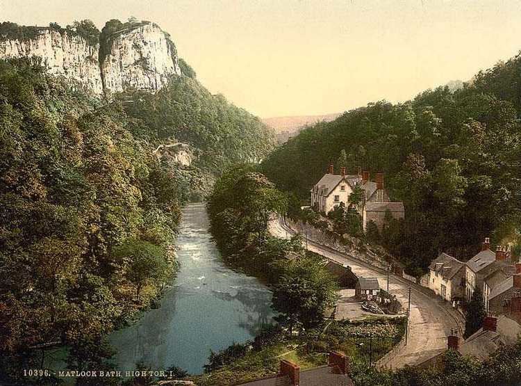
The route of the River Derwent downstream (south) of Matlock is especially interesting to geologists in that it appears to have cut its way through a limestone gorge below High Tor (120m above river level), rather than follow the "simpler" way to the east. It is thought that landslips and/or glaciation may have had an influence over how the present route of the river was established.
The Dimple
The area on the western edge of the town, bounded on the north and east by Old Hackney Lane, Hurds Hollow, and Dimple Road, and on the south by Bakewell Road, is named as Dimple, on the Ordnance Survey map.
Bank Road Tram
In 1893, Matlock Cable Tramway, a cable tramway was built up Bank Road from Crown Square at Matlock Bridge to Wellington Street (at the top of Bank Road) with a stop halfway up at Smedley Street where Smedley's Hydro (built by John Smedley) was situated. Conceived by Job Smith, the tram was inspired by San Francisco's famous cable cars, and cost £20,000. When it was built it was the steepest tramway in the world at a gradient of 1 in 5½, and it rose 300 feet (91 m). The fare was tuppence up, penny down. It closed in 1927 after losing business to cars and buses.
Railways
In 1849, the railway came to Matlock. Matlock railway station was opened on the Manchester, Buxton, Matlock and Midlands Junction Railway, later the Midland line between London and Manchester, until the section between Matlock and Buxton was closed in 1968 following the Beeching cuts. Network Rail considered re-opening the line, with a study carried out by the county council. Although it proved to be unfeasible in the short term, the track bed will be kept free of development as the study showed that the line could be economically viable from around 2025. The section from Wye Dale (about 3 miles (4.8 km) east of Buxton) to Coombs viaduct, a point about a mile south-east of Bakewell, has now become the Monsal Trail, an 8.5-mile (13.7 km) walk and cycle trail.
Trains still run between Matlock and Derby on the Derwent Valley Line. Peak Rail, a preserved railway, runs steam trains on a section of the closed line between Matlock, Darley Dale and Rowsley. Previously it used its own station, Matlock Riverside, a short distance to the north of the mainline station, however as of 2011 both Peak Rail and trains on the Derwent Valley Line share the same station.
Hall Leys Park
Hall Leys Park is a Victorian public park in the centre of Matlock, Derbyshire which opened in 1898. It lies between the River Derwent to the south and Causeway Lane to the north. The park has many facilities and in 2004–2005 underwent major regeneration as part of the Matlock Parks Project with funding from the Millennium Commission.
At the Crown Square/Matlock Bridge end of the park there is the town's war memorial and a wishing well. Beside this there is the shelter from the former cable tramway which was moved to the park when the tramway ceased to operate in 1927.
Moving away from Crown Square there is, next, a large grass area and some tennis courts. As part of the refurbishments which took place, the old grass tennis courts were replaced with a skateboard park.
In the centre of the park is the Victorian bandstand which is used regularly in the summer months by local brass bands and for events such as the annual Matlock Victorian Christmas Weekend - held on the first weekend of December. Beside the bandstand is a footbridge over the River Derwent which has markings indicating the height of several floods that hit the town in the 1960s and 1970s. The café, on the opposite side of the bandstand, has similar markings for other floods.
Hall Leys Park is now a central part of the town's flood protection. The wall which surrounds the northern side of the park has the ability to have the footways sealed with sheets of wood which would dam the progress of any overflow from the river and turn the entire park into a large reservoir. Further down the park there is a putting green and a Crown Green Bowls green.
A boating lake, with several small islands, is home to a large number of birds, including ducks and moorhens as well as being host to the longest running pleasure boats in the country.
A miniature railway runs half the length of the park along the river but, due to the lack of any turning space, the return journey is made in reverse.
At the far end of the park is a children's playground which was significantly upgraded in 2005.
Hall Leys Park is occasionally the site for visiting "Continental Markets" and, since the summer of 2006, regular "Farmers' Markets". It is also the centre of the Matlock Victorian Christmas Weekend held annually on the first weekend of December.
Bank Road
Bank Road runs from Crown Square up Matlock Bank, a steep hill which gives the road its name, to Wellington Street. Although many consider the whole incline to be Bank Road, just over halfway up beyond Smedley Street the road is called Rutland Street. Bank Road has many local landmark buildings along it - from the bottom of the hill (Crown Square) travelling north:
NB. Beyond Smedley Street, Bank Road is actually Rutland Street.
Dale Road
Dale Road runs all the way from Matlock Bridge (road bridge over the River Derwent) to North Parade in Matlock Bath. It forms part of the Derby to Manchester road (A6) and has very many bends. Dale Road, like Bank Road (see previous section), contains a large number of examples of Victorian architecture, although only four are listed by English Heritage. However all buildings on Dale Road are included in two conservation areas created by Derbyshire Dales District Council. These conservation areas are called "Matlock Bridge" (from the bridge over the Derwent to the railway bridge over Dale Road), then "Matlock Dale" to the outskirts of Matlock Bath. In this section, the main features of Dale Road are described, starting at Matlock Bridge and then proceeding in a southerly direction until the High Tor Hotel.
Sport
Matlock is home to Matlock Town Football Club playing in the Northern Premier League Premier Division at their Causeway Lane ground.
Matlock is also home to Matlock Cricket Club playing next to the football ground, and Matlock and District Swimming Club (also known as MAD Swimming) which trained and competed in the nearby old Matlock Lido before it closed in August 2011 with subsequent events transferred to the Arc complex.
Matlock's rugby team play their home matches at nearby Cromford Meadows. They run 3 senior teams and the 1st XV compete at Level 6 in the RFU league structure. Matlock Rugby Club also has a thriving minis and junior section with over 250 members all supported by fully qualified mini and junior coaches. In 2007 the club was awarded the Derbyshire Tigger Price Memorial trophy for the team of the year award.
On the outskirts of Matlock off the A6 Bakewell Road, a new multi-use leisure centre and swimming facility was opened in 2011 known as Arc Leisure Matlock.
Education & Arts
Matlock creative and performing arts were enhanced in 2004 when the annual arts festival Matlock Live! began. It takes place in June or July each year featuring local musicians, dancers, artists, etc. The local secondary school, Highfields School, achieved status as a Performing Arts College due to its connections with Matlock Live! As part of the summer event, Matlock Live invites Buskers / Street performers to form a busking trail around Matlock raising money for the charity Aquabox. Matlock Music present a series of public concerts at Highfields School (Upper Lumsdale site). Storytelling is also well represented with a monthly venue at the Imperial Rooms.
Education history
The first school in Matlock was founded in 1647 as a free school for local boys, originally funded by local George Spateman of Tansley and from 1668 by Anthony Wolley. This school was rebuilt in 1829 and expanded in 1860 and 1889 and girls first attended in 1816. This school has since been demolished (the date is unknown).
Another school, All Saints Primary School was founded in 1875 to provide for the population of the newly developed Matlock Bank. This school still operates and is the biggest primary school in Matlock. In 1897, a third school, the Council School, was constructed on Matlock Bank, at the junction of Smedley Street and Chesterfield Road. It also still operates as Castle View Primary School.
Before Highfields School was founded in 1982, when the tripartite education system in Matlock ended, there were two secondary schools in Matlock; Charles White Secondary Modern School (founded in 1956, and named after two local MPs, father and son, the latter of who died in 1956) and Ernest Bailey's Grammar School (founded in 1924 and named after its wealthy founder).
As a Grammar school, Bailey's accepted students whose parents paid or who gained scholarships (by passing the Eleven plus exam) until fees were phased out, leaving scholarship as the only means of entry. Those who didn't attain a scholarship attended Charles White - it is estimated that Charles White students outnumbered Bailey's students 3:1. White had been built especially by Derbyshire County Council to accommodate the children who couldn't attend Bailey's.
The two schools were merged to create Highfields, a comprehensive school. The site of Charles White in Starkholmes became the 'lower site' of Highfields for years 7-8, while Bailey's was converted to the county council records offices. A new site was built to house the new 'upper site' at Lumsdale for years 9-13.
The town centre development
For over 10 years, the council had proposed to allow a Sainsbury's supermarket to be built in Cawdor Quarry, a disused quarry next to the railway station. In early 2007 building work started, and it opened 4 October 2007. A new access road with its own bridge over the River Derwent allows the A6 to bypass the town centre, while the old bridge has been restricted to one-way traffic (out of town) and allows pedestrian access to the train station, a newly built bus station and the supermarket from the town centre. Several bus routes continue to serve only the old Bus Station on Bakewell Road, making Matlock one of the smallest towns in Britain to boast two bus stations.
There has been a negative image of Matlock Town centre due to the limited retail offer for a town of Matlock's size which was identified in the Matlock Masterplan - a document produced by the district council. There has been a worry that many locals now choose to shop in neighbouring towns due to this perceived problem. The local council had a wider development planned for the future with key development sites on Bakewell Road, Firs Parade and Imperial Road which were identified in 2007 in the masterplan.
In 2010, Crown Square was updated with the replacement of pavements and street furniture intended to provide a new look more appropriate to the conservation area, the old tarmac pavements and traffic island being rebuilt in local sandstone, barriers replaced with heritage bollards and all the street lights replaced. Bakewell Road and Firs Parade were not included in this phase as they are just off Crown Square, and along with Imperial Road they are yet to be redeveloped.
Matlock on film and television
Youth hostels
The Youth Hostels Association (YHA) has its national headquarters in the former Severn Trent Water building on Dimple Road, Matlock. YHA has had two hostels in the town. The first (1933–1934) in Tor Dale and the second (1983–2007) in Bank Road. Despite the close proximity of the Head Office, Bank Road closed in 2007 as part of a restructuring exercise. It has subsequently been redeveloped.