
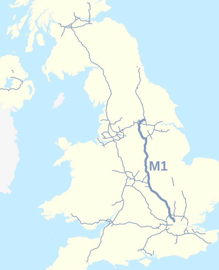
Existed: 1959–60 – present Length 311.4 km | History: Completed in 1999 North end: Hook Moor (A1(M)) | |
 | ||
Primarydestinations: LondonEdgwareAylesburyWatfordSt AlbansLutonMilton KeynesNorthamptonRugbyLeicesterLoughboroughBirminghamCoventryNottinghamDerbyMansfieldChesterfieldSheffieldRotherhamManchesterBarnsleyWakefieldBradfordLeedsWetherbyYork | ||
The M1 is a south-north motorway in England connecting London to Leeds, where it joins the A1(M) near Aberford. It was the first inter-urban motorway to be completed in the UK; the first road to be built to motorway standard in the country was the Preston By-pass, which later became part of the M6.
Contents
- Map of M1 Nottingham NG16 UK
- History
- First section 1959
- Rugby to Leeds 1965 to 1968
- Leeds South Eastern Urban Motorway 1972
- Lighting
- Safety barriers
- Leeds to Hook Moor 1999
- London extensions 1966 1967 and 1977
- Recent developments
- M1 J19 reconstruction
- A5 M1 Link Dunstable Northern Bypass
- M1 J28J31 managed motorways
- M1 J32J35a managed motorways
- M1 Junctions 3942 managed motorways
- M1M69 junction
- Other proposals
- Incidents and accidents
- List of sights visible from the M1
- References
Map of M1, Nottingham NG16, UK
The motorway is 193 miles (311 km) long and was constructed in four phases. Most of the motorway was opened between 1959 and 1968 but the southern end was extended in 1977 and the northern end was extended in 1999. It forms part of the unsigned European route E13.
History
There had been plans since before the Second World War for a motorway network in the United Kingdom. Lord Montagu formed a company to build a 'motorway like road' from London to Birmingham in 1923; however it was a further 26 years before the Special Roads Act 1949 was passed which allowed for the construction of roads limited to specific vehicle classifications, and the 1950s when the country's first motorways were given the government go-ahead.
The first section of motorway was the Preston Bypass in Lancashire, which opened in 1958 (now part of the M6 motorway). The M1 was Britain's first full-length motorway and opened in 1959. The early M1 had no speed limits, no central reservation or crash barriers, and no lighting.
First section, 1959
The first section of the motorway opened between Junction 5 (Watford) and Junction 18 (Crick/Rugby) on 2 November 1959 together with the motorway's two spurs, the M10 (from Junction 7 to south of St Albans originally connecting to the A1) and the M45 (from Junction 17 to the A45 and Coventry). Parts of the Hertfordshire section were built using steam rollers.
The M1 was officially inaugurated from Slip End (close to Luton), this was celebrated by a large concrete slab on the bridge next to the village with inscription "London-Yorkshire Motorway – This slab was sealed by the Rt Hon Harold Watkinson M.P. – Minister of Transport – Inauguration Day – 24th March 1958". It was removed during widening works in 2007-08.
This section of the M1 broadly follows the route of the A5 north-west. It starts at the Watford Bypass (A41), which runs south-east to meet the A1 at Apex corner, and ended on the A5 at Crick. The M10 spur motorway connected the M1 to the North Orbital Road (A405/A414, a precursor of the M25) where it also met the A5 (now renumbered here as the A5183) and, 2 miles (3.2 km) to the east via the A414, the A6, which subsequently became part of the M25.
Although the whole of first section opened in 1959, it was built in two parts with the northern part (Junctions 10 to 18) being built by John Laing and the southern part (the St Albans Bypass) being built by Tarmac Construction.
Rugby to Leeds, 1965 to 1968
The continuation of the motorway from Junction 18 towards Yorkshire was carried out as a series of extensions between 1965 and 1968. Diverging from the A5, the motorway takes a more northerly route through the East Midlands, via Leicester, Loughborough, Nottingham to Sheffield, where the M18 splits from the M1 at Junction 32 to head to Doncaster.
Originally, the M1 was planned to end at Doncaster but it was decided to make what was going to be the "Leeds and Sheffield Spur" the primary route with the 11-mile (18 km) section to the A1(M) south of Doncaster given the separate motorway number M18.
From Junction 32, the motorway passes Sheffield, Rotherham, Barnsley and Wakefield, reaching the original end of the motorway at (the original) Junction 44 to the east of Leeds. There were plans to route the M1 from just south of Junction 42 where it interchanges with the M62, round the west of Leeds to the A1 at Dishforth; the chosen route passes to the east of Leeds. With the M62 and M621, the M1 forms a ring of motorways around the south of Leeds.
Leeds South Eastern Urban Motorway, 1972
In 1972 an extension of the M1 was opened into central Leeds as the Leeds South Eastern Motorway where it met the Leeds South Western Motorway (M621) coming north-east from the M62 at Junction 3.
Lighting
In July 1972 the then UK Minister for Transport Industries, John Peyton announced that 86 miles (138 km) of UK motorway particularly prone to fog would benefit from lighting in a project which "should be" completed by 1973. Sections to be illuminated included the M1 between Junctions 3 and 14, and between Junctions 16 and 24. In August 2011, the Highways Agency announced that despite being converted to Smart Motorway status, the lights will be switched off on stretches of the motorway between Junctions 10 (Luton) and 15 (Northampton) without affecting road user safety. The motorway junctions and their approaches, and a section of the M1 on either side of Junction 11 (north Luton), would have lighting columns replaced and remain lit. All lighting columns from Junctions 10 to 14 have now been removed completely, apart from some slip roads.
Safety barriers
An increasing official interest in secondary safety was evident in an announcement in March 1973 that work would shortly begin on erecting "tensioned safety barriers" along the central reservation of a 34-mile (55 km) section of the M1 between Kegworth (J24) and Barlborough (J30).
Leeds to Hook Moor, 1999
Between 1996 and 1999 the M1 section north of the M62 underwent a major reconstruction and extension to take the M1 on a new route to the A1(M) at Aberford. The new road involved the construction of a series of new junctions, bridges and viaducts to the east of Leeds. When the new section of M1 was completed and opened on 4 February 1999, the Leeds South Eastern Motorway section of the M1 was redesignated as the M621 and the junctions were given new numbers (M621 Junctions 4 to 7).
London extensions, 1966, 1967 and 1977
The M1 was extended south from its original starting point at Junction 5 towards London in three stages. The first stage, opened in 1966, took the motorway south-east, parallel to the A41 to meet the A5 at junction 4 south of Elstree. The second phase continued east to Scratchwood (the London Gateway Service Area occupies the location of the missing junction 3 from where an unbuilt spur would have connected to the A1 at Stirling Corner to the north-east). The M1 then runs south alongside the Midland Main Line towards Hendon where it meets the A1 again at Junction 2 via a tightly curved flyover section. These flyovers connecting from the A1 were originally both for northbound traffic; the left one as the on-ramp to the M1, the right one going over the A1/A41 junction beneath to rejoin the A1 northbound.
Junction 2 is about 2.5 miles (4 km) south of the original Junction 3. Before the completion of Junction 2, southbound traffic left the motorway via a slip road which passed around the back of the now disused homebase and under the A41/A1 Mill Hill Bypass and looped round to join it at Fiveways Interchange. This slip road is still visible to southbound traffic approximately 650 yards (590 m) before Junction 2 and was maintained until the early 2000s though not accessible to traffic. The northbound slip road from the A1 is now partially used as the entrance way to a retail park and was once carried by bridge but no longer reaches the northbound carriageway as it is cut off by the motorway continuing south.
The final section of the M1 was opened to Junction 1 at Staples Corner in 1977. There the motorway meets the North Circular Road (A406) at a grade separated junction and roundabout. Unrealised plans made in the 1960s would have seen the motorway continue through the junction on an elevated roadway to end at West Hampstead where it would have met the North Cross Route, the northern section of the London Motorway Box, a proposed ring of urban motorway around the central area. The layout of the Staples Corner junction was originally built in accordance with these plans although most of the London Ringways Plan had been cancelled by 1973. Around the same time the section between the M10 and Junction 5 was widened from the original two lanes to three.
On its completion, the M1 acted as a fast link road between London and Birmingham. It also provided a link to London Luton Airport for these regions, and its proximity to the site of the Milton Keynes new town (designated in 1967) meant that it was soon providing a vital transport link to another major area.
Recent developments
In 2006 plans were published for the widening of 91 miles (146 km) from Leicester through to Leeds (Junctions 21–42) to dual 4-lanes.
Work began on 10-mile (16 km) section between the M25 and Luton (Junctions 6a and 10) in 2006 and opened in 2009 which included the construction of new parallel roads between Junctions 7 and 8 for local traffic together with the widening or replacement of eleven underbridges on one or both carriageways and replacing seven overbridges at a cost of £294 million. A variable speed limit system (MIDAS) was installed and the M10 spur was reclassified as part of the A414 road. Escalating costs across the whole of the Highways Agency programme, including the M1 project, where costs had risen to £5.1 billion, road protests and criticisms by the Transport Select Committee and the National Audit Office led to wide-ranging re-assessments of the Agency's project costs. Widening was scaled back to section from M25 to Luton (Junctions 6a to 10) that was already in progress and from Nottingham and Mansfield (Junctions 25–28). Hard-shoulder running being to be used for other sections.
Work to widen the 15-mile (24 km) section from Nottingham to Mansfield (J25-J28) to dual 4-lanes began in January 2008 and was completed in 2010 at a cost of £340 million. Average speed cameras, installed initially only for the period of construction, proved to be so effective that they were retained permanently.
Work to introduce Hard shoulder running on approximately 15 miles (24 km) of motorway between Luton and Milton Keynes (J10-13) was completed in December 2012 at a total cost of £327 million. Modifications were also made to Junctions 11 and 12 and the A421 road from Junction 13 to the Bedford southern bypass was upgraded to dual two-lane during this period
M1 J19 reconstruction
Following a public inquiry in March 2013 the Secretary of State for Transport announced on 18 July 2013 that work to update the Catthorpe Interchange between the M1 motorway, M6 motorway and A14 road close to Catthorpe would go ahead. Work on the £191 million 3 layer interchange started in January 2014 and the scheme was fully opened to traffic in December 2016.
A5-M1 Link (Dunstable Northern Bypass)
The A5-M1 Link (Dunstable Northern Bypass) is to be a two-lane dual carriageway running east from the A5 north of Dunstable to join the M1 at a new Junction 11a south of Chalton. Here, it is intended to join with a proposed Luton Northern Bypass to form a northern bypass for the wider conurbation. The A5-M1 Link aims to alleviate traffic congestion in Houghton Regis and Dunstable, reduce journey times for long-distance traffic travelling through Dunstable and improve the regional economy. The Highways Agency is expected to detrunk the A5 through Dunstable when the A5-M1 Link opens to the public in early 2017. As part of the Dunstable Town Centre Masterplan, Central Bedfordshire Council is building the 2.9 km Woodside Link to connect the new junction 11a to the industrial areas of Dunstable and Houghton Regis. Most of the road will open to traffic in autumn 2016 with the remaining section connecting to junction 11a when it opens.
M1 J28–J31 managed motorways
There is a plan to introduce managed motorway technologies between Junctions 28 (Mansfield) A38 and 31 (Sheffield) A57 with work scheduled to take place between 2012 and 2015.
M1 J32–J35a managed motorways
Provisional plans exist for a managed motorway scheme including dynamic hard shoulder running on the M1 motorway between Junctions 32 and 35a serving South Yorkshire and in particular the urban areas of Sheffield and Leeds was confirmed in November 2010.
M1 Junctions 39–42 managed motorways
Provisional plans exist for a managed motorway scheme including dynamic hard shoulder running on the M1 motorway between Junctions 39 and 42 serving South Yorkshire and in particular the urban areas of Wakefield and Leeds was announced in November 2010 which includes a link to the M62 at Junction 42.
M1/M69 junction
There are plans to widen the M1 to dual 4-lane or dual 5-lane between Junctions 21 and 21a and construct a new link road between the M1 and the M69 including a new road bridge to take southbound M1 traffic over the motorway to connect to the M69. During this work the Leicester Forest East services would be closed. Consultation took place in 2007 and a completion date of 2014 is suggested. However the Highway Agency separately suggests that scheme development will "recommence" in 2014/15 with a provisional programmed start of works 2017/18.
Other proposals
In addition to the above schemes, the Highways Agency also plans to add capacity and improve flows on the following sections of motorway in the longer term.
Plans to dual the A421 from Junction 13 to Milton Keynes and to add capacity to Junction 10a on the Luton spur are being developed.
Incidents and accidents
List of sights visible from the M1
The M1 is the only UK motorway to use transition curves (spirals) to connect straights to curves (circles) as is usual with railways. This was found to be unnecessary and curves connect directly to straights (or curves of a different radius) on later motorways.