
Population 320 (2011) Sovereign state United Kingdom Postcode district NN6 | OS grid reference SP6068 Post town Northampton Local time Sunday 12:46 PM | |
 | ||
Weather 21°C, Wind S at 18 km/h, 54% Humidity | ||
Watford is a village and civil parish in the Daventry district of the county of Northamptonshire in England. It should not be confused with the more significant town of Watford in Hertfordshire which is 55 miles to the south. At the time of the 2001 census, the parish's population was 224 people, including Murcott and increasing to 320 at the 2011 Census. Watford is home to Watford Gap services Britain's oldest motorway service station opening in 1959. Located directly on the M1 motorway and alongside the West Coast Main Line.
Contents
- Map of Watford Northampton UK
- The Roman era to the 5th century
- Anglo Saxon period
- 1066 and later
- Medieval era
- Present day
- Notable buildings
- Notable residents
- References
Map of Watford, Northampton, UK
The Roman era to the 5th century
It is known that the important Roman road “Watling Street” was constructed on the western boundary of the village. In the Roman era the Roman settlement of Bannaventa (A Gap in the Hills), with defensive earth and timber ramparts and a ditch, was situated about 2 miles south-west of Watford. Today some remains of the settlement such as building platforms, mounds and crop marks are still visible.
Anglo-Saxon period
After the departure of the Romans, the area eventually became part of the Anglo-Saxon kingdom of Mercia. Watford is mentioned as one of the lands belonging to Ethelgifu and was probably inherited from her own kindred. In the 7th century the Mercians converted to Christianity with the death of pagan King Penda. About 889 the area was conquered by the Danes and became part of the Danelaw – with Watling Street serving as the boundary. This was in effect until the area was recaptured by the English about 917 under Wessex King Edward the Elder, son of Alfred the Great. In 940 the Vikings of York captured Northamptonshire and devastated the area, with the county retaken by the English in 942. Norhamptonshire is one of the few counties to have both Saxon and Danish town-names and settlements.
1066 and later
In 1066 the local Saxon lord is recorded as Thor, a common Scandinavian name that may have dated back to the Viking invasions of several centuries prior. The first known recording of the affairs of Watford village is in the Domesday Book of 1086. At that time Watford was considered a fairly large village with a population that could have been more than 100 people. By 1086 the Saxons had been ousted by the Normans and Gilbert the Cook was Lord and Tenant-in-Chief of Watford and another parish. Baldwin was the son and successor of Gilbert in the reign of King Henry I. By the time Baldwin died in the first year of Henry II, Watford was held by the Barony of Brunn which was held by Baldwin. The Barony and Watford with it passed to the husband of one of Baldwin's daughters, Hugo Wac, who became the Baron of Brunn succeeding his wife's father.
Medieval era
Watford has extensive settlement remains for an earlier form of the village in the medieval era. There is a stone building, and remains of gardens, traces of medieval dwellings, house-sites, paddocks, etc. Additionally, there are reconstructed cottages from this era. The significance of the medieval village remains at Watford is underscored by the adjoining ridge and furrow, evidence of an extensive medieval cultivation system which provided rich, well-drained land for crop planting.
Present day
It is known nationally for its proximity to the Watford Gap motorway service station. The phrase "North of Watford Gap" is used light-heartedly (and generally in the confused sense mentioned above) to describe areas of Great Britain that are north of London. It is also used in a generic sense to distinguish the South from the North of England. The phrase may refer to the village being traditionally an important waypoint on the old east-west and north-south coaching routes. This was the point where the main north-south road, rail and canal routes came together at a gap in the hills known as Watford Gap. Watford gives its name to the Watford Locks on the Grand Union Canal.
Notable buildings
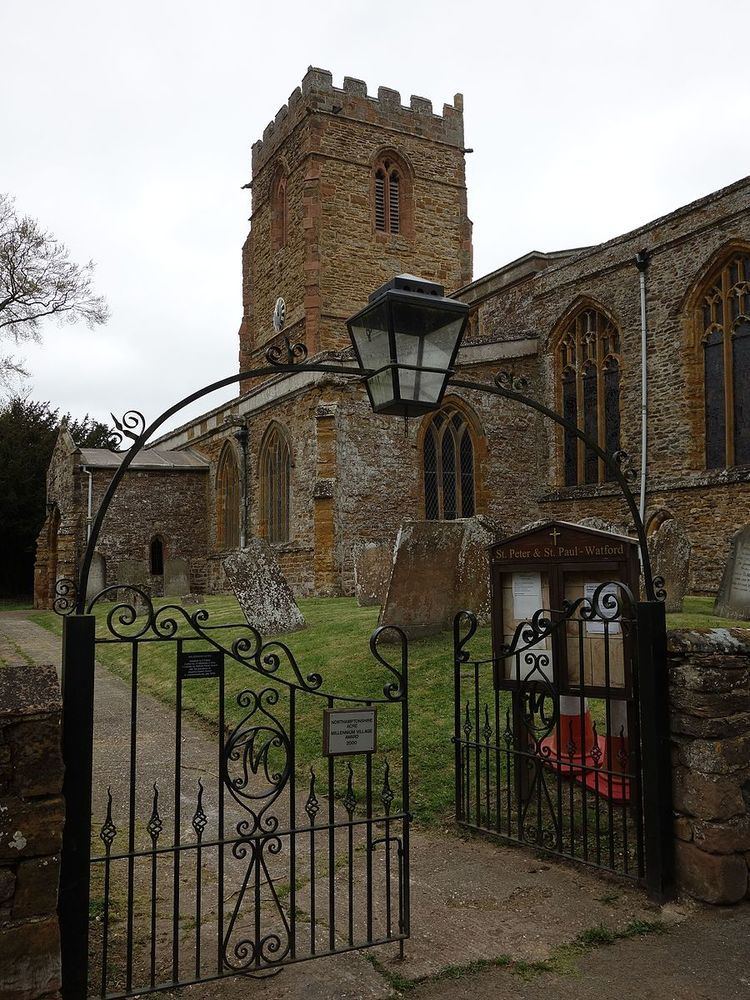
The Historic England website contains details of 21 listed buildings and one scheduled monument in the parish of Watford. All of the listed buildings are Grade II except for St Peter & St Paul's Church which is Grade I. The properties concerned include:
Notable residents
Pilgrim Father Thomas Rogers was born in Watford about 1572. He was the son of William Rogers and his wife Eleanor. He married Alice Cosford at Watford in 1597 and had six children baptised there between 1599 and 1613. The family joined the Separatist Church in Leiden, the Netherlands sometime after 1613. Thomas Rogers became a citizen of Leiden on 25 June 1618 and records state he was a merchant of camlet cloth (a combination of silk and camel’s hair). It is possible Alice Rogers died sometime before 1620 since, per 1622 records, a woman named Elizabeth (Elsgen), possibly his second wife, cared for the Rogers children left behind when Thomas and his son Joseph sailed for the New World.
Thomas Rogers and his son Joseph, about age 18, went to North America on the Pilgrim ship Mayflower in 1620, while his other children remained in the Netherlands. Some of those children are known to have later gone to New England. Thomas died, as did many others on the ship, that first winter in Plymouth Colony, 1620-21. His son Joseph survived to live a long life as a person of note in the colony.