
Population 821 (in 2011) Civil parish Longbridge Deverill Dialling code 01985 Post town Warminster | OS grid reference ST869409 Unitary authority | |
 | ||
Longbridge Deverill is a village and civil parish about 2.5 miles (4.0 km) south of Warminster in Wiltshire, England. It is on the A350 primary route which connects the M4 motorway and west Wiltshire with Poole, Dorset.
Contents
Map of Longbridge Deverill, Warminster, UK
The parish is in the Deverill valley which carries the upper waters of the River Wylye. It includes the village of Crockerton and the hamlet of Hill Deverill; these are collectively known as the Lower Deverills (the Upper Deverills being the upstream villages of Brixton Deverill, Monkton Deverill and Kingston Deverill).
Local government
The parish elects a parish council. It falls within the area of the Wiltshire Council unitary authority, which is responsible for all significant local government functions.
The village falls in the 'Warminster Without' electoral ward. This ward starts in the north at Upton Scudamore, avoids Warminster then stretches south through Longbridge Deverell to end at Kingston Deverill. The total population of the ward taken at the 2011 census was 4,163.
Buildings
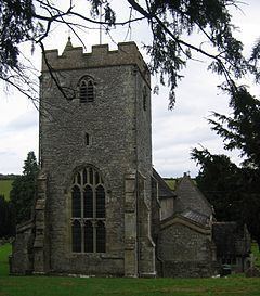
The Church of England parish church of Saints Peter and Paul is partly Norman. It has memorials to the Thynne family including John Thynne (1515-1580) who built Longleat House.
Longbridge Deverill has a public house, the George Inn.
The manor house at Hill Deverill dates from the 16th century and is Grade II* listed.