
Population 248 (in 2011) Unitary authority Country England Dialling code 01985 Post town Warminster | OS grid reference ST846371 Region South West Sovereign state United Kingdom Ceremonial county Wiltshire UK parliament constituency South West Wiltshire | |
 | ||
Kingston Deverill is a village and civil parish in Wiltshire, England. Its nearest towns are Mere, about 4 miles (6.4 km) to the southwest, and Warminster, about 6 miles (9.7 km) to the northeast. The parish and its demographic figures include the village of Monkton Deverill.
Contents
Map of Kingston Deverill, Warminster, UK
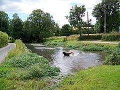
The parish is in the Deverill Valley which carries the upper waters of the River Wylye. The six villages of the valley - Kingston, Monkton, Brixton Deverill, Hill Deverill, Longbridge Deverill and Crockerton - are known as the Deverills.
The Church of England parish church is St Mary's.
Local government
Until 1934, Monkton Deverill was a separate parish.
The parish elects a joint parish council with neighbouring Brixton Deverill. The combined council is Upper Deverills Parish Council.
Kingston Deverill falls within the area of the Wiltshire Council unitary authority, which is responsible for all significant local government functions.