
Type Freeway Length 46 km | Opened 1959 | |
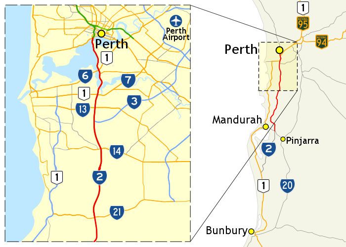 | ||
The Kwinana Freeway is a 72-kilometre (45 mi) freeway in and beyond the southern suburbs of Perth, Western Australia, linking central Perth with Mandurah to the south. It is the central section of State Route 2, which continues north as Mitchell Freeway to Joondalup, and south as Forrest Highway towards Bunbury. A 4-kilometre (2.5 mi) section between Canning and Leach highways is also part of National Route 1. Along its route are interchanges with several major roads, including Roe Highway and Mandjoogoordap Drive. The northern terminus of the Kwinana Freeway is at the Narrows Bridge, which crosses the Swan River, and the southern terminus is at Pinjarra Road, east of Mandurah.
Contents
- Map of Kwinana Fwy Western Australia Australia
- To perth cbd by kwinana freeway
- Route description
- Swan and Canning Rivers
- Southern suburbs of Perth
- South of Rowley Road
- History
- Initial construction
- First extension
- Further extensions
- New Perth Bunbury Highway
- Bus transitway
- 2005 flooding
- Widening
- Future works
- References
Map of Kwinana Fwy, Western Australia, Australia
Planning for the Kwinana Freeway began in the 1950s, and the first segment in South Perth was constructed between 1956 and 1959. The route has been progressively widened and extended south since then. During the 1980s, the freeway was extended to South Street in Murdoch, and in June 2001, it reached Safety Bay Road in Baldivis. The final extension began as the New Perth Bunbury Highway project, constructed between December 2006 and September 2009. In early 2009, the section north of Pinjarra Road was named as part of the Kwinana Freeway, with the remainder named Forrest Highway. The freeway has been adapted to cater for public transport, with the introduction of bus priority measures in 1987, and the 2007 opening of the Mandurah railway line, constructed in the freeway median strip.
To perth cbd by kwinana freeway
Route description
The Kwinana Freeway is the central section of State Route 2. It commences at the northern end of the Narrows Bridge, Perth, continuing south from the Mitchell Freeway, and terminates at the Pinjarra Road interchange at Barragup, where it then transitions to Forrest Highway. All intersections with the freeway are grade separated. Route access is controlled and the speed limit is 100 kilometres per hour (60 mph) north of Safety Bay Road, while south of the road route access is uncontrolled, though it remains a state route and the speed limit becomes 110 kilometres per hour (70 mph). From Perth to Mill Point Road, the freeway has five lanes northbound and six lanes southbound. This includes a bus lane in each direction, except on the Narrows Bridge, which only has a southbound bus lane. South of Mill Point Road to Roe Highway the freeway has three lanes in each direction, without any bus lanes except for bus-only ramps at the Canning Bridge interchange. At the Roe Highway interchange, an extra southbound lane is added, providing four lanes southbound and two lanes northbound, until the Armadale Road/Beeliar Drive interchange in Cockburn, where the freeway is reduced to two lanes in each direction until Pinjarra Road. Works are currently underway to add an extra lane southbound between Armadale Road/Beeliar Drive, and Russell Road in Hammond Park. The median strip of the freeway north of The Spectacles also houses the Mandurah railway line. A shared pedestrian and bicycle path is built alongside the freeway.
Main Roads Western Australia monitors traffic volume across the state's road network, including many locations along the Kwinana Freeway. The busiest section is at the northern end, on the Narrows Bridge, which averaged over 93,000 vehicles per weekday in 1979. This increased to over 135,000 in 1988/89, 156,000 in 1998/99, and 160,000 in 2007/08. The volume generally declines as the freeway travels south, with the fewest vehicles recorded near the southern end. There were fewer than 46,000 vehicles per weekday near the Canning Highway terminus in 1978, while in 1998/89 there were under 45,000 north of South Street. For 1998/99 there were fewer than 27,000 vehicles per weekday north of Thomas Road, and during 2007/08 fewer than 38,000 were recorded between Mundijong Road and Safety Bay Road. As of 2013, the Kwinana Freeway is one of the most congested commuter routes in Perth, during peak traffic periods. The average speed when driving north from Cockburn Central was measured as less than 40 kilometres per hour (25 mph) during the morning peak. The slowest section was from South Street to Canning Highway, with an average travel speed of 24 kilometres per hour (15 mph). During the afternoon peak, the worst segment was southbound between Manning Road and Leach Highway, with a 31 kilometres per hour (19 mph) average speed.
Swan and Canning Rivers
The Kwinana Freeway begins at the Narrows Bridge, and travels south from The Narrows alongside the Swan and Canning Rivers. South of the bridge is a northbound exit to Mill Point Road, whilst the southbound exit and both entrance ramps to the freeway are located a further 600 metres (2,000 ft) south. To the east of the freeway are residential homes in South Perth and Como, as well as the Royal Perth Golf Club. There is a southbound exit to South Terrace which provides access to the local area. Public access to the Swan River's foreshore is available via footbridges that cross the freeway.
The first major interchange is with Canning Highway. National Route 1 is allocated to Canning Highway to the east, and to the Kwinana Freeway to the south of the interchange. The design is a diamond interchange, with additional bus-only ramps connecting to the median lanes of the freeway. The Canning Bridge bus and railway transfer station is located at the interchange. A partial Y interchange with Manning Road, consisting of a northbound entrance ramp and southbound exit ramp, is located 400 metres (1,300 ft) south of Canning Highway. These ramps merge with the ramps on the south side of the Canning Highway interchange, allowing access between the highway and Manning Road. The Kwinana Freeway continues south, with the suburbs of Manning and Salter Point to the east, and Canning River to its west. The freeway passes by Aquinas College, 1.5 kilometres (0.93 mi) south of Manning Road, and reaches the Mount Henry Peninsula after another 600 metres (2,000 ft).
The 660-metre-long (2,170 ft) Mount Henry Bridge carries the freeway across the Canning River, from Salter Point to Mount Pleasant. The freeway travels through the suburb for 450 metres (1,480 ft) to Cranford Avenue, a half-diamond interchange with northbound entrance and southbound exit ramps. The Kwinana Freeway continues south for another 600 metres (2,000 ft) through Brentwood to Leach Highway.
Southern suburbs of Perth
Through the southern suburbs of Perth, the Kwinana Freeway travels south as the boundary between various suburbs. The Leach Highway interchange houses the Bull Creek train and bus interchange station, and the Murdoch Station is co-located with the South Street interchange, 2.2 kilometres (1.4 mi) further south. Halfway between these interchanges, Parry Avenue crosses the freeway via an overpass, connecting the suburbs of Bateman and Bull Creek. Beyond South Street, the land east of the Kwinana Freeway, in the suburb of Leeming, continues to be residential, whilst to the west the freeway passes by educational and health care facilities in Murdoch. Challenger TAFE, Murdoch University, St John of God Murdoch Hospital, and Fiona Stanley Hospital are adjacent to the freeway, though there is no direct access. The next interchange, after 1.4 kilometres (0.87 mi), is with Farrington Road, which marks the southern edge of Murdoch. This is a half-diamond interchange that only serves traffic travelling to or from areas further north.
A free-flowing trumpet interchange, 800 metres (2,600 ft) south of Farrington Road, connects the Kwinana Freeway to Roe Highway. The interchange is situated between four suburbs: Leeming, (north-east), North Lake (north-west), Bibra Lake, (south-west), and Jandakot. Roe Highway is part of State Route 3, Perth's ring route, and is a major controlled-access link to Perth's north-east. There are plans to extend Roe Highway west to Hamilton Hill, which would necessitate upgrading the interchange. Following Roe Highway, the freeway continues its journey south, between the residential areas of South Lake and Jandakot. Houses east of the freeway surround the Glen Iris Public Golf Course. After 2.7 kilometres (1.7 mi) there is a diamond interchange with Berrigan Drive, after which the freeway passes lower density lots in Cockburn Central and the industrial section of Jandakot. The freeway reaches the next interchange after 2.1 kilometres (1.3 mi), connecting with Armadale Road to the east and Beeliar Drive to the west. The Cockburn Central train station is located in the freeway median, 300 metres (980 ft) north of the interchange. The freeway continues travelling south through the developing outer metropolitan suburbs of Atwell and Aubin Grove, east of the freeway, and Success and Hammond Park, west of the freeway. Here it connects to Russell Road and Gibbs Road via a diamond interchange after 3.3 kilometres (2.1 mi), and to Rowley Road after a further 2.6 kilometres (1.6 mi).
South of Rowley Road
South of the Rowley Road diamond interchange, development is sparse, except in Bertram, southwest of the Thomas Road interchange. The freeway progresses through swampy rural land for 3.4 kilometres (2.1 mi), passing by Lake Balmanup in Wandi on its way to the diamond interchange at Anketell Road. The Kwinana Freeway continues south along the edge of Jandakot Regional Park, near to The Spectacles Wetlands, reaching Thomas Road after another 2.4 kilometres (1.5 mi). The Mandurah rail line deviates from the freeway median 1 kilometre (0.62 mi) north of the interchange, thereafter travelling south-west towards Rockingham. From Thomas Road to the next interchange at Mortimer Road, 2.7 kilometres (1.7 mi) further south, the land to the west of the freeway in Bertram has been developed into a residential area. After the latter interchange, development again becomes sparse, as the freeway travels south near swampland and bodies of water, including Folly Pool and Maramanup Pool. The next interchanges are with Mundijong Road after 4.7 kilometres (2.9 mi), Safety Bay Road after another 3.9 kilometres (2.4 mi), and Karnup Road following a further 5.2 kilometres (3.2 mi). There is a pocket of newly developed urban land near Safety Bay Road, south of the freeway.
South of Karnup Road, the following two interchanges are constructed as dogbone interchanges, which use roundabouts instead of traffic lights to control the intersections between ramps. The Kwinana Freeway follows the Serpentine River southwards, with no interchanges for 7.4 kilometres (4.6 mi). At this point, there is an interchange with Paganoni Road to the west and Vine Road to the east. After 5 kilometres (3.1 mi) the freeway leaves the Perth Metropolitan Region, and encounters the next interchange with Lymon Road and Mandjoogoordap Drive. Lymon Road provides access to Stake Hill, although Mandjoogoordap Drive is not a controlled access route into Mandurah. Following this interchange, the freeway turns south-east, where it encounters a diamond interchange with Lakes Road after 4.6 kilometres (2.9 mi). The freeway ends 7.6 kilometres (4.7 mi) further south, at the Pinjarra Road folded diamond interchange in Ravenswood. The road, and State Route 2, continue south as Forrest Highway towards Bunbury.
History
The Kwinana Freeway began as a proposed controlled-access road to link the Narrows Bridge in Perth with the developing area of Kwinana. Planning began in 1954, after the concept had been announced by the Acting-Premier John Tonkin on 24 July 1953. The original route travelled through South Perth to Canning Highway, and included a new bridge over the Canning River. The planned route was later adjusted so that it crossed the river further south, due to the expected traffic volume, and difficulties in construction and traffic management at the existing Canning River Bridge.
Initial construction
In 1956, the Government of Western Australia decided to construct the first section of the freeway, between the Narrows Bridge and Canning Highway. An extension was planned to be constructed seven years later. This first stage was built alongside the Swan River, on the edge of South Perth. Undeveloped land was used where possible, and the edge of the river was filled in at various points. Access to the river was maintained via five pedestrian bridges over the freeway, leading to the existing Como Beach and Jetty, and new areas on the river foreshore created during the project. A significant change to the foreshore was the relocation of the South of Perth Yacht Club. In 1960, the club moved from the Canning River's eastern shore, at Olives Reserve in Como, to Coffee Point in Applecross, on the western shore. The termination of the Kwinana Freeway at Canning Highway meant that the highway would be part of the main link between Perth and Kwinana, along with the freeway and Stock Road. Therefore, Canning Highway was upgraded to a dual carriageway. The upgrade works included the construction of a new bridge across the Canning River, next to the existing bridge, built in 1938. This allowed for six lanes of traffic on Canning Highway. Construction of this stage was completed in 1959, before the establishment of the Environmental Protection Authority (EPA) in 1971. In 1974, this first section was described by the EPA as "environmental desecration". This was primarily due to the public being denied access to the foreshore environment. Pedestrian overpasses were described as ineffective for "obvious physical [and] psychological reasons", and the impact on the riverfront was described as a "blight which has descended there".
First extension
The first major work on the freeway after it opened was the construction of a new interchange in South Perth in the 1970s. The interchange included a complicated bridge design, which began at Judd Street, crossed over the freeway, and curved down to join the northbound carriageway. The $2.7 million interchange was opened on 13 December 1976 by the Minister for Works, Ray O'Connor. This was followed by a southern extension, which would be constructed alongside the environmentally sensitive area surrounding Canning River. Preparation work included an extensive study on the effects on the environment and community, the most detailed to be undertaken in Western Australia thus far. The EPA recommended abandoning the concept of a freeway, for both the existing road and the first extension, to restore accessibility to the foreshore. The Main Roads Department disagreed that a lower standard at-grade road would be sufficient, as large volumes of traffic were forecast, and any pedestrian access would be "extremely dangerous". Main Roads contended that a grade separated road would be the safest and most efficient option for both pedestrian and vehicles. A botanical report on the extension found that no unique species or ecological unit would be under threat from the proposal, and the Swan River Conservation Board had no objections. The extension was then approved by the State Government in 1974, and by the Federal Government in 1975.
As part of the extension project, construction began in 1976 on the Canning Interchange at Canning Highway. This interchange included a flyover bridge from Manning Road, which utilised a curved design similar to the South Perth Interchange bridge. The Canning Interchange opened on 19 July 1979. Construction works south of the interchange began in 1979. The freeway was initially planned to terminate at Leach Highway, but was extended as far as South Street, at the request of the Melville City Council. The council wanted the extra length of freeway to alleviate congestion on its local roads, and contributed $600,000 to expedite the construction. This stage included construction of the Mount Henry Bridge across the Canning River. As of 1997, it is Western Australia's longest bridge, at a length of 660 metres (720 yd). The 6.5-kilometre (4.0 mi), $35.8 million extension was opened on 9 May 1982 by Ray O'Connor, then Premier of Western Australia. Additional works undertaken to prepare for the opening included widening the existing stretch of freeway to three lanes in each direction, and reconfiguring the Narrows Bridge to include an additional central lane, reversible during peak traffic flows.
Further extensions
For the next stage of the freeway, an extension south to Thomas Road, multiple routes were investigated. The preferred route was selected based on the least impact from a combination of engineering, social, and environmental factors. The environmental factors considered were conservation areas associated with Thompsons Lake, west of the alignment, three "good quality" wetlands along the alignment, as well as patches of vegetation that were considered "nothing special". The conservation of these areas and associated vegetation was considered desirable. This extension was completed in two stages. The first was a 7.1-kilometre (4.4 mi) extension to Forrest Road, which opened on 12 December 1991, at a cost of $36.7 million. Subsequently, the freeway was extended a further 11.7 kilometres (7.3 mi) to Thomas Road. Main Roads looked for opportunities to improve the environment during the planning of this segment. These included the establishment of a protected strip of vegetation alongside the freeway, and the preservation or enhancement of remnant wetlands under threat from urban expansion. The main negative impacts of construction would be controlled through vegetation reinstatement and drainage management plans, as well as the use of "standard techniques" for preventing pollution, which was recognised as a severe environmental impact. The proposed route had the least environmental consequences compared with viable alternatives, and was the Department of Environment and Conservation's preferred route. The impact on wetlands was further investigated by the EPA in 1992. The EPA estimated that 50 hectares (120 acres) of wetland habitat would be lost, including 20 hectares (49 acres) with conservation status. The EPA's report concluded that the alignment was not ideal from an environmental standpoint, but recognised the social importance of constructing the freeway, which would facilitate development of the area. The authority was satisfied that the project's environmental repercussions could be managed, with the key recommendation of replacing the function of impacted wetlands. This $31 million section had three at-grade traffic light controlled intersections, which were designed to be replaced by grade separated interchanges. Intersections were used to avoid delaying the extension, as Main Roads Western Australia considered the $30 million cost for interchanges to be prohibitively expensive. The extension opened on 11 September 1994; the Town of Kwinana contributed $1 million, per an agreement on completing the freeway prior to 1995.
In 1988, the State Planning Commission proposed defining a reservation for the extension of the Kwinana Freeway to the southern edge of Perth Metropolitan Region, north-east of Mandurah. The northern and southern sections of the route were predetermined by factors including existing and proposed developments, power transmission lines, the location of wetlands and the Serpentine River, and required setbacks from an explosives depot at Baldivis. A number of routes were investigated for the central section, between Mortimer Road and Stakehill Road. The EPA found all proposed routes acceptable, and that the preferred route minimised environmental impact. A report for a later stage regarded the approval for this section as lacking strict stipulations for the management of environmental impact, which was attributed to the assessment of the era not being subject to recent environmental regulations and scrutiny. A 12-kilometre-long (7.5 mi) extension along this alignment, to Safety Bay Road in Baldivis, was opened on 23 June 2001 by Premier Geoff Gallop. This project also included grade separation of the existing at-grade intersections. The Kwinana Freeway Bus Transitway was completed soon afterwards, in February 2002.
New Perth Bunbury Highway
Construction of an extension to the freeway, initially known as the "New Perth Bunbury Highway", began in December 2006. The project consisted of a 32-kilometre (20 mi) freeway-standard extension to Pinjarra Road and the Murray River at South Yunderup, and a 38-kilometre (24 mi) highway-standard dual carriageway to Old Coast Road at Lake Clifton. It had undergone an environmental assessment by the EPA in 2000. Main Roads proposed management plans for each environmental factor identified by the EPA. Only clearing of vegetation critical for road construction would be undertaken, and more vegetation would be replaced than the amount impacted, using local native species. A flora survey found no rare species, and only one priority species, Lasiopetalum membranaceum, near the southern end of the project. Road construction would impact one conservation class wetland, but no protected wetlands. To minimise impact, road drainage would be designed to contain spills, and prevent direct discharges into the surrounding environment. Noise levels would be contained to an acceptable limit in the road design, in accordance with the Main Roads traffic noise policy. The EPA concluded that the road could be designed and managed to an acceptable standard. Main Roads' 2006 plan for environmental management of the project included numerous aspects, described as best management practices, which for the northern segment of the project were beyond the environmental approval requirements. Specific plans were developed regarding fauna, vegetation, dieback and weeds, and revegetation and rehabilitation. Other areas with specific plans included topsoil management, drainage, construction (covering dust, noise, and vibrations), foreshores, and both Aboriginal and European heritage. The actual road names were not known until early 2009, when Transport Minister Simon O'Brien revealed that the section south of Pinjarra Road would be known as Forrest Highway, with the section to the north to become part of the Kwinana Freeway. The route bypasses Mandurah by taking traffic around the eastern side of the Peel-Harvey Estuary prior to joining the existing dual carriageway on Old Coast Road, reducing the journey time from Perth to Bunbury. The Kwinana Freeway extension and Forrest Highway were opened on 20 September 2009, with a ceremony held at the interchange between the freeway, highway, and Pinjarra Road. The roads were officially opened by Premier Colin Barnett, Senator Chris Evans, Transport Minister Simon O'Brien, Member for Canning Don Randall, and the previous Transport Minister Alannah MacTiernan.
Bus transitway
Dedicated bus lanes have existed on the Kwinana Freeway since the late 1980s, when a project was set up to decrease bus commuters' travel times into Perth from suburbs south of the Swan River. In 1987, Main Roads Western Australia and Transperth trialled a contraflow bus lane along the Kwinana Freeway, from the Canning Interchange to the Narrows Interchange. The lane operated between 7:00 am and 9:30 am, the period with the most traffic congestion on the freeway. After two months, the results were examined, and the agencies decided to build an additional bus lane on the northbound carriageway. The construction included bus-only ramps at the beginning and end of the lane. The works were mainly funded by Transperth, which contributed $8.22 million out of the $10.23 million total cost. The remaining $2.01 million was provided by Main Roads Western Australia. The bus lane opened on 20 November 1989, and received an Institute of Engineers award for engineering excellence.
In 1999, the state government announced that a two way bus transitway would be built in the Kwinana Freeway median, to link Perth's Esplanade Busport with the Murdoch station at South Street. Construction of the first stage, between the Narrows Interchange and Canning Interchange, began in September 2000, and was completed in February 2002. The bus transitway was replaced by the Mandurah railway line, constructed in the freeway median between May 2004 and December 2007. After rail services commenced, most freeway bus services ceased; however, dedicated ramps and short priority lanes remain for bus services between Canning Highway and Perth.
2005 flooding
During the afternoon on 13 May 2005, a water pipe burst near the southbound Mill Point Road entrance ramp in South Perth, releasing 7 megalitres (1,500,000 imp gal; 1,800,000 US gal) of water and 60 tonnes (59 long tons; 66 short tons) of sand. This caused widespread flooding in the area, submerged the southbound lanes of the freeway, and collapsed the ramp. There was traffic gridlock in the city and much of the metropolitan area, lasting throughout the afternoon and into the night. Repairs to the entrance ramp took more than a week to be completed.
Widening
In March 2011, it was announced that the Kwinana Freeway between Leach Highway and Roe Highway would be widened from two to three lanes in each direction. The $58 million project was brought forward to ease increased congestion on this part of the freeway. Construction began in July 2011, with completion scheduled for May 2012. The new southbound lane opened on 1 June 2012. On 20 December 2012, the State Transport Minister Troy Buswell, with Federal MP Gary Gray and State MLA for Riverton Mike Nahan, officially opened the northbound lane. By May 2013, all major construction works had been completed, including a pedestrian underpass at South Street, a new carpark and access road for Murdoch railway station, and noise walls. Remaining landscaping works were expected to be finalised in September 2013, and the whole projected had been completed by mid-October.
Future works
Widening of the Kwinana Freeway with an extra southbound lane between Roe Highway and Armadale Road began in mid-2014. The project aims to increase the freeway's reliability, efficiency, and safety, as the current two-lane configuration is subject to a large proportion of heavy vehicles and severe peak hour congestion. The project also involves the realignment of ramps at Berrigan Drive and Armadale Road, construction of noise barriers and noise walls where required, and installation of components for intelligent transport systems – optic fibre communications, vehicle detection devices, and closed circuit cameras.
There are preliminary plans for a southbound entrance ramp from the Manning Road interchange. The land requirements have been included on the Perth Metropolitan Region Scheme; however, the project is not a State Government priority, and no funds have been allocated for its design or construction. The City of South Perth considers the ramp a "major priority" that would increase its road network connectivity, reduce traffic congestion, and improve commuter safety. In 2001, the City estimated the construction cost to be $1.77 million.