
Founded 5th century BC Time zone CET (UTC+1) Local time Friday 9:26 PM | Municipality Kotor Municipality Settlements 56 Area code +382 32 Postal code 85330 | |
 | ||
Weather 9°C, Wind S at 3 km/h, 84% Humidity Points of interest Kotor Cathedral, Lovćen, Our Lady of the Rocks, Sveti Đorđe, Sveti Marko Island | ||
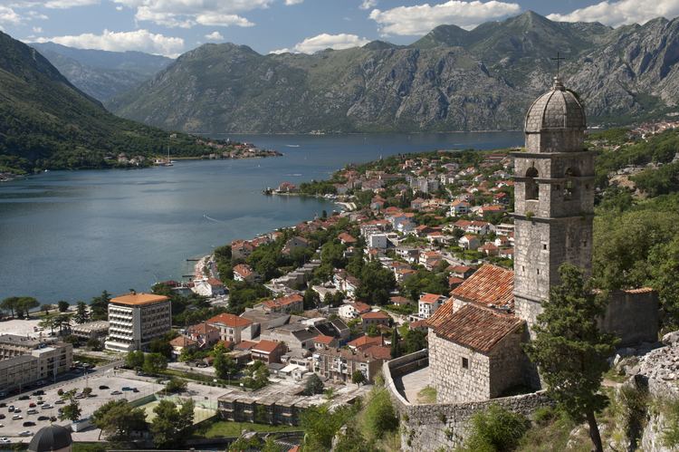
Budva kotor things to do in montenegro balkan road trip 04
Kotor (Montenegrin Cyrillic: Котор, [kɔ̌tɔr]) is a coastal town in Montenegro. It is located in a secluded part of the Gulf of Kotor. The city has a population of 13,510 and is the administrative center of Kotor Municipality.
Contents
- Budva kotor things to do in montenegro balkan road trip 04
- Map of Kotor Montenegro
- Top 10 best travel cities in 2016 number 1 kotor in montenegro
- Geography
- Climate
- Roman era
- Middle Ages
- Venetian and Ottoman rule
- Habsburg and Napoleonic rule
- World War II
- Main sights
- Culture
- Demographics
- The ethnic composition of the settlements 2003
- Transport
- Twin towns
- References
Map of Kotor, Montenegro
The old Mediterranean port of Kotor is surrounded by fortifications built during the Venetian period. It is located on the Bay of Kotor (Boka Kotorska), one of the most indented parts of the Adriatic Sea. Some have called it the southern-most fjord in Europe, but it is a ria, a submerged river canyon. Together with the nearly overhanging limestone cliffs of Orjen and Lovćen, Kotor and its surrounding area form an impressive and picturesque Mediterranean landscape.
In recent years, Kotor has seen a steady increase in tourists, many of them coming by cruise ship. Visitors are attracted both by the natural beauty of the Gulf of Kotor and by the old town of Kotor. Kotor is part of the World Heritage Site dubbed the Natural and Culturo-Historical Region of Kotor.
Top 10 best travel cities in 2016 number 1 kotor in montenegro
Geography
It is located in a secluded part of the Gulf of Kotor.
Climate
Kotor has a humid subtropical climate (Cfa).
Roman era
Kotor, first mentioned in 168 BC, was settled during Ancient Roman times, when it was known as Acruvium, Ascrivium, or Ascruvium (Ancient Greek: Ἀσκρήβιον) and was part of the Roman province of Dalmatia.
Middle Ages
Kotor has been fortified since the early Middle Ages, when Emperor Justinian built a fortress above Acruvium in 535, after expelling the Ostrogoths. This town was named as Kotor in 9th century. According to this source, in appointing the future town of Kotor, at the time the Hungarians often burst into the Bosnian Kingdom and that are repeatedly ravaged the territory of the Bosnian town of Kotor, which is the second book of Geography Gerard Rudniger marked as Vesekatro, "which is close to Banja Luka". It is possible that the vase derives from the notion of vassal (lat.vassallus, vassus = servant, from vassal of king of the Franks, and later other European rulers, who gets possession of the king as "leno" or feud) and possessive adjective cataro(= katar). One can not exclude the possibility that the Vasekatro was a refuge and/or settlement of Katars because they have the same root of vase Latin term for the noun vase (vasis, pl. vāsa, vasōrum = vessel, war machine), and guarantor, or endorser (= văs, vădis).
The noblemen of the Bosnian Kotor, called Nendor, Miroslav, and Vuksan, along with some others, when he heard that the walls a new town on the sea, and they went with all his assets of high value in gold and silver to a known location, since the Bosnian Kingdom was rich in minerals of precious metal (gold, silver etc). When, according to Mihajlo Solinjanin (in the description of Dalmatia), arrived in Risan, announced their intention to raise the fortress in which to be sure. When they learned citizens of the settlement Ascrivium, urged that the planned cost of investing in the construction of a current city, "and that combined live as true friends and citizens".
"Bosnians, who are usually like, not accepting this proposal immediately but a few days later said, that they are willing to comply with their request, but under the condition that the new city called the name of their homeland, Kotor. These are not accepted by Ascrivians, or later (says Solinjanin), under the influence of its bishops are agreed to throw the draw, and so they decide what name to call the city. And Draw outbursts in favor of Kotor's Bosnians."
The city (probably Ascrivium) was plundered by the Saracens in 840. Kotor was one of the more influential Dalmatian city-states of romanized Illyrians throughout the Middle Ages, and until the 11th century the Dalmatian language was spoken in Kotor. The city was part of Byzantine Dalmatia in that period.
In 1002, the city suffered damage under the occupation of the First Bulgarian Empire, and in the following year it was ceded to Serbia by the Bulgarian Tsar Samuil. However, the local population resisted the pact and, taking advantage of its alliance with the Republic of Ragusa, only submitted in 1184, while maintaining its republican institutions and its right to conclude treaties and engage in war. It was already an episcopal see, and, in the 13th century, Dominican and Franciscan monasteries were established to check the spread of Bogomilism.
During the Nemanjić dynasty-era, the city was autonomous. 1371 it came under suzerenity of Hungarian king who ruled Croatia and Hungary, and 1384. it became part of Bosnian banate under ban/king Tvrtko. Until 1420 it was independent. The city acknowledged the suzerainty of the Republic of Venice in 1420. In the 14th century, commerce in Kotor competed with that of the nearby Republic of Ragusa and of the Republic of Venice.
Venetian and Ottoman rule
The city was part of the Venetian Albania province of the Venetian Republic from 1420 to 1797. It was besieged by the Ottomans in 1538 and 1657. Four centuries of Venetian domination have given the city the typical Venetian architecture, that contributed to make Kotor a UNESCO world heritage site.
In the 14th- and 15th centuries, there was an influx of settlers from the oblasts of Trebinje (the region around forts Klobuk Ledenica and Rudina) and the Hum lands (Gacko and Dabar) to Kotor. The Italian name of the city is Càttaro. Under Venetian rule, Kotor was besieged by the Ottoman Empire in 1538 and 1657, endured the plague in 1572, and was nearly destroyed by earthquakes in 1563 and 1667. It was also ruled by Ottomans at brief periods.
Habsburg and Napoleonic rule
After the Treaty of Campo Formio in 1797, it passed to the Habsburg Monarchy. However, in 1805, it was assigned to the French Empire's client state, the Napoleonic Kingdom of Italy by the Treaty of Pressburg, although in fact held by a Russian squadron under Dmitry Senyavin. After the Russians retreated, Kotor was united in 1806 with this Kingdom of Italy and then in 1810 with the French Empire's Illyrian Provinces. Kotor was captured by the British in an attack on the Bay led by Commodore John Harper in the brig sloop HMS Saracen (18 guns). To seal off Kotor, residents along the shore literally pulled the ship in windless conditions with ropes. The Saracen's crew later hauled naval 18-pounder guns above Fort St. John, the fortress near Kotor, and were reinforced by Captain William Hoste with his ship HMS Bacchante (38 guns). The French garrison had no alternative but to surrender, which it did on 5 January 1814.
It was restored to the Habsburg Monarchy by the Congress of Vienna. Until 1918, the town, then known as Cattaro, was head of the district of the same name, one of the 13 Bezirkshauptmannschaften in the Kingdom of Dalmatia.
In World War I, Kotor was one of three main bases of the Austro-Hungarian Navy and homeport to the Austrian Fifth Fleet, consisting of pre-dreadnought battleships and light cruisers. The area was the site of some of the fiercest battles between local Montenegrin Slavs and Austria-Hungary. After 1918, the city became a part of Yugoslavia and officially became known as Kotor.
World War II
Between 1941 and 1943 the Kingdom of Italy annexed the area of Kotor which became one of three provinces of the Italian Governorate of Dalmatia - the Province of Cattaro had an area of 1,075 km2 (415 sq mi) and population of 128,000.
Main sights
Kotor has one of the best preserved medieval old towns in the Adriatic and is a UNESCO world heritage site. It is home to numerous sights, such as the Cathedral of Saint Tryphon in the old town (built in 1166), and the ancient walls which stretch for 4.5 km (3 mi) directly above the city. Sveti Đorđe and Gospa od Škrpijela islets off the coast of Perast are also among the more popular destinations in the vicinity of Kotor.
Culture
Kotor hosts several summer events, such as the Summer Carnival or Bokeljska Noć. Together with Budva, and the small town of Tuzi, near Podgorica, the city hosted the Federation of European Carnival Cities (FECC) World Carnival City Congress in May 2009.
Demographics
Kotor is the administrative centre of Kotor municipality, which includes the towns of Risan and Perast, as well as many small hamlets around the Bay of Kotor, and has a population of 22,601.
The town of Kotor itself has 961 inhabitants, but the administrative limits of the town encompass only the area of the Old Town. The urban area of Kotor also includes Dobrota (8,819) and Škaljari (3,807), bringing the population of Kotor's urban area close to 13,000 inhabitants. The total number rises to around 15,000 if the neighbouring hamlets of Muo, Prčanj and Stoliv are included. The entire population of Kotor Municipality was 22,947, as of the 2003 census.
Demographics
Ethnic composition of the municipality in 2011:
According to documents from 1900, Kotor had 7,617 Catholics, and 7,207 Orthodox Christians. Kotor is still the seat of the Catholic Bishopric of Kotor, which covers the entire gulf. In 2011, 78% citizens of Kotor were Orthodox Christians, while 13% were listed as Roman Catholic.
The ethnic composition of the settlements (2003)
Relative ethnic majority:
Transport
Kotor is connected to the Adriatic Motorway and the rest of the coast and inland Montenegro by Vrmac Tunnel. Inland is reachable by detouring from Adriatic motorway at Budva or Sutomore (through Sozina tunnel). There is also a historic road connecting Kotor with Cetinje, which offers spectacular views of Kotor bay.
Tivat Airport is 5 kilometres (3.1 mi) away, and there are regular flights to Belgrade, Moscow and Paris and dozens of charter planes land daily on Tivat airport during the summer season.
Podgorica Airport is 65 kilometres (40 mi) away, and it has regular flights to major European destinations throughout the year.