Country Bosnia and Herzegovina Highest elevation 300 m (1,000 ft) Time zone CET (UTC+1) Local time Friday 9:26 PM | Entity Republika Srpska Lowest elevation 275 m (902 ft) Area 560 km² Area code +387 (51) | |
 | ||
Weather 10°C, Wind S at 10 km/h, 54% Humidity | ||
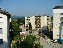
Kotor Varoš or Kotor-Varoš (Serbian Cyrillic: Котор Варош) is a town and municipality in north-western Bosnia and Herzegovina, Republika Srpska.
Contents
- Map of Kotor VaroC5A1 Bosnia and Herzegovina
- Roman Ages
- Middle Ages
- Modern
- Settlements
- Features
- Twin towns Sister cities
- References
Map of Kotor Varo%C5%A1, Bosnia and Herzegovina
Roman Ages
From the Roman period there are several sites in Šiprage at the mouth Crkvenica – in Vrbanja river ("at the field of Omer Bey Šipraga," 1891), discovered the remains of an early Christian Basilica (3rd – 5th century).
Archaeological records confirm the existence of a Roman settlement in this location, while tufa stećci has testified to the Oldbosnian (Bogomils) settlement in the twelfth century. The original location of stećci was confluence of rivulet Crkvenica and River Vrbanja (at the very rivers' banks). They were cut out and built in the walls of the surrounding buildings (possibly due to the beliefs of their miraculous properties). One of the best preserved stećak is submerged in River Vrbanja, in the immediate proximity of its primary location.
Middle Ages
It has been theorized that Kotor Varoš was mentioned in the De Administrando Imperio as "Katera" (Greek: Κατερα), a part of the "land of Bosnia".
First Kotor village, medieval city Kotor, there is certainly a lot before the 9th century, because, according to credible sources, prior to that was "several times plundered"." According to this source, in appointing the future town of Kotor, at the time the Hungarians often burst into the Bosnian Kingdom and that are repeatedly ravaged the territory of the Bosnian town of Kotor, which is the second book of Geography Gerard Rudniger marked as Vesekatro, "which is close to Banja Luka". It is possible that the vase derives from the notion of vassal (lat.vassallus, vassus = servant, from vassal of king of the Franks, and later other European rulers, who gets possession of the king as "leno" or feud) and possessive adjective cataro(= katar). One can not exclude the possibility that the Vasekatro was a refuge and/or settlement of Katars because they have the same root of vase Latin term for the noun vase (vasis, pl. vāsa, vasōrum = vessel, war machine), and guarantor, or endorser (= văs, vădis).
The noblemen of the Bosnian Kotor, called Nendor, Miroslav, and Vuksan, along with some others, when he heard that the walls a new town on the sea, and they went with all his assets of high value in gold and silver to a known location, since the Bosnian Kingdom was rich in minerals of precious metal (gold, silver etc.). When, according to Mihajlo Solinjanin (in the description of Dalmatia), arrived in Risan, announced their intention to raise the fortress in which to be sure. When they learned citizens of the settlement Ascrivium, urged that the planned cost of investing in the construction of a current city, "and that combined live as true friends and citizens".
"Bosnians, who are usually like, not accepting this proposal immediately but a few days later said, that they are willing to comply with their request, but under the condition that the new city called the name of their homeland, Kotor. These are not accepted Ascrivians, or later (says Solinjanin), under the influence of its bishops are agreed to throw the draw, and so they decide what name to call the city. And Draw outbursts in favor of Kotor's Bosnians."
The town was part of the Donji Kraji province of the Banate of Bosnia in the 13th century. In the 14th century, the town was the property of the Hrvatinić noble family.
Modern
Austro-Hungarian rule in Bosnia and Herzegovina began in 1878 and ended with the establishment of the Kingdom of Serbs, Croats and Slovenes in 1918, later renamed Kingdom of Yugoslavia. The town was part of the Vrbas Banovina (1929–41), while after World War II it became part of the Socialist Republic of Bosnia and Herzegovina.
During the Bosnian War (1992–95), some religious and cultural monuments and landmarks were destroyed by Serb paramilitary groups, such as a Catholic church in the centre of the town, as well as all of the mosques. In the southern Čaršija (bazaar) quarter of the town nearly all houses were destroyed. Bosnian Serb-dominated parts of the town were largely unaffected. Bosnian Serb police and military forces devastated surrounding villages too, especially those upstream along the Vrbanja to Kruševo Brdo, as well as all non-Serbs villages downstream to Banja Luka. All settlements in the Vrbanja valley were sacked and much of the Bosniak and Croat population left the municipality.
*1. – Pilana
Settlements
• Baština • Bilice • Boljanići • Borci Donji • Borci Gornji • Ćorkovići • Duratovci • Garići • Grabovica • Hadrovci • Hrvaćani • Hanifići • Jakotina • Kotor Varoš • Kruševo Brdo • Liplje • Maljeva • Maslovare • Obodnik • Orahova • Palivuk • Plitska • Podbrđe • Podosoje • Postoje • Prisočka • Radohova • Ravne • Selačka • Sokoline • Stopan • Šibovi • Šiprage • Tovladić • Vagani • Varjače • Večići • Viševice • Vranić • Vrbanjci • Zabrđe • Zaselje
Features
The city also features a large monument to the local partisans who died for Yugoslavia during the fighting with the German and Ustaša forces during WW2.
Twin towns – Sister cities
Kotor Varoš is twinned with:
Populated places in Bosnia and Herzegovina
