
 | ||
Explore british columbia a road trip in bc s west kootenays
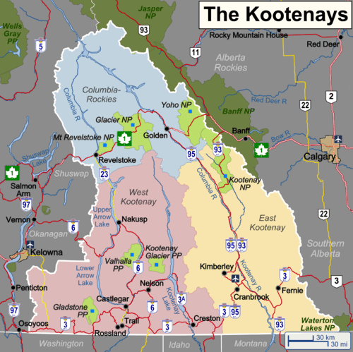
The Kootenay (/ˈkuːtni/ KOOT-nee) region (in common parlance "The Kootenays") comprises the southeastern portion of British Columbia. It takes its name from the Kootenay River, which in turn was named for the Ktunaxa (or Kootenai or Kutenai) First Nation first encountered by explorer David Thompson.
Contents
- Explore british columbia a road trip in bc s west kootenays
- Arts culture road trip british columbia s west kootenays
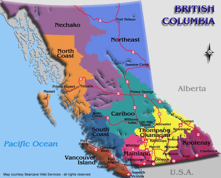
- Boundaries
- Naming and subdivision
- Economy
- References
Arts culture road trip british columbia s west kootenays
Boundaries
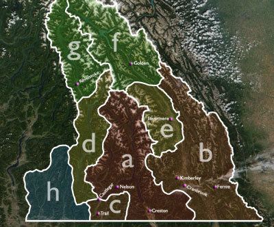
The Kootenays are more or less defined by the Kootenay Land District, though some variation exists in terms of what areas are or are not a part. The strictest definition of the region is the drainage basin of the lower Kootenay River from its re-entry into Canada near Creston, through to its confluence with the Columbia at Castlegar (illustrated by a, right). In most interpretations, however, the region also includes:
Some or all of the following areas to the north, which drain into the Columbia River, are also commonly included in the Kootenays:
When the above regions are added, sometimes the region's name is morphed into Columbia-Kootenay or Kootenay-Columbia, although that terminology also includes the Big Bend Country and Kinbasket Lake, to the north of Golden and Revelstoke, which is not generally considered part of the Kootenays, though part of the Kootenay Land District.
Finally, the Boundary Country, a southern east-west corridor between the Okanagan and the Bonanza Pass and drained by the basins of the Kettle and Granby Rivers, is sometimes mentioned as being in the West Kootenay, and in other reckonings as being part of the Okanagan. In actuality, the settlement of the Boundary Country predates development in either of the regions it is now attached to, as is also the case with the Similkameen Country to the west of the Okanagan. In some descriptions, the Boundary Country includes Osoyoos and Oliver in the South Okanagan (rather than the other way around). The Boundary Country is (illustrated by h) In the event of its inclusion, the Kootenays could be described as the complete Canadian portion of the Columbia Basin minus lands drained by the Okanagan River.
Naming and subdivision
Contingent on the above boundaries, the Kootenays are commonly split either into East and West, or East, Central and West.
It remains unclear why both Kootenay and Kootenays are used somewhat interchangeably to describe the area. The plural form is in reference to The Kootenays, both East and West; the singular is in reference to the Kootenay Region. In practice the two terms are used interchangeably, although one indicates a geographical region and the other a legal boundary, the Kootenay Land District, which was identical with the original federal and provincial Kootenay ridings.
Economy
Originally settled by miners and smelter workers, the district now includes an important fruit-growing section (Creston Valley) and numerous commercial centres, including Grand Forks, Robson, Ymir, Warfield, Montrose, Fruitvale, Salmo, Trail, Nelson, Slocan, Playmor, Winlaw, Cranbrook, Kimberley, Fernie, Castlegar, Rossland, Erickson,and Creston.
A number of Community Radio stations have developed in the region, most notably CJLY-FM in Nelson and CIDO-FM in Creston. These stations usually operate either as Cooperatives or as a non-profit Societies.