
Designated 1971 Road Trans-Canada Highway Range Selkirk Mountains | Elevation 1,330 m Province British Columbia | |
 | ||
Traversed by BC 1Trans-Canada Highway and Canadian Pacific Railway Location Glacier National Park, British Columbia, Canada Official name Rogers Pass National Historic Site of Canada Similar Rocky Mountains, Selkirk Mountains, Kicking Horse Pass, Illecillewaet Glacier, Canadian Rockies | ||
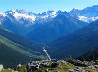
Rogers Pass (elevation 1,330 m or 4,360 ft) is a high mountain pass through the Selkirk Mountains of British Columbia used by the Canadian Pacific Railway and the Trans-Canada Highway. The pass is a shortcut across the "Big Bend" of the Columbia River from Revelstoke on the west to Donald, near Golden, on the east. The pass was discovered on May 29, 1881, by Major Albert Bowman Rogers, a surveyor working for the Canadian Pacific Railway. A second pass was named for Rogers in 1887 in Montana, c.373 miles to the south-east.
Contents
- Map of Rogers Pass Columbia Shuswap A BC Canada
- Geography
- Discovery
- Canadian Pacific Railway
- Trans Canada Highway
- Climate
- References
Map of Rogers Pass, Columbia-Shuswap A, BC, Canada
Rogers Pass is in the heart of Glacier National Park, in the midst of mountains popular for ski mountaineering, camping, hiking and mountain climbing ever since the region became accessible in 1886. The location has tourist services including the Rogers Pass Discovery Centre and National Park services. Rogers Pass is commemorated as a National Historic Site of Canada.
Geography
Rogers Pass is a narrow valley surrounded by a number of mountains. It is formed by the headwaters of the Illecillewaet River to the west and by the Beaver River to the east. Both of these rivers are tributaries of the Columbia River, which loops about 240 km around to the north of the pass.
Rogers Pass is known for its winter snowfall, which amounts to about 10 metres per year. Because of steep mountains, avalanches are very common in winter. When the railway first went over the pass, 31 snow sheds with a total length of about 6.5 km were built to protect the railway from the avalanches. Snow sheds for the Trans-Canada Highway were built later, including large ones in 1962. To keep the highway and railway open during the winter, the Royal Canadian Artillery uses 105 mm howitzers to knock down the avalanches under controlled circumstances so traffic is not caught in unexpected avalanches.
Discovery
During the 1870s when the Canadian Pacific Railway was being planned, the preferred route through the Rocky Mountains was the northerly Yellowhead Pass. When the railway construction project was turned over to a private company in 1881, the route was changed to the Kicking Horse Pass. While the railway was being built across the prairies, the railway company had to find a pass over the unexplored Selkirk Mountains, or else it would have to detour around them via the Big Bend.
Major A. B. Rogers was hired in April 1881 by the railway company to find the pass with the promise of having the pass named after him and a $5000 bonus. Walter Moberly had discovered Eagle Pass just to the west, and based on suggestions in Moberly's reports, Rogers started out from what is now Revelstoke, up the Illecillewaet River. Running out of food, Rogers and his party almost reached the summit but turned back feeling reasonably confident that a pass existed. Rogers returned the following year, 1882, from the east and reached a point where he could see where he had stopped the previous season, confirming that the pass existed and was good enough for the railway rapidly approaching across the prairies. Rogers was reluctant to cash the $5000 cheque, and instead framed it for his wall until CPR General Manager William Cornelius Van Horne offered him a gold watch as an incentive to cash it.
Canadian Pacific Railway
When the railway was built through the pass in 1884, the eastern approach up the Beaver River required some of the largest bridges on the line, including the often-photographed Stoney Creek Bridge. A series of loops were used on the west side of the pass to deal with the steep hill and avoid the avalanche routes. After the Canadian Pacific Railway was completed in the fall of 1885, the railway was shutdown for the winter to observe the avalanches. In response, 31 snow sheds were built, with a total length of about 6.5 km.
Some major avalanches that came without warning caused the railway serious loss of life and property. In 1899, 8 people were killed when an avalanche destroyed the train station at the pass. On March 4, 1910, the CPR suffered its worst loss. A crew and rotary snowplow were working to clear a snow slide when a second slide from the opposite side of the valley came down, killing 62 men.
To avoid the avalanches the 8 km (5.0 mi) Connaught Tunnel was completed under Rogers Pass in 1916. At the time, this was the longest railway tunnel in North America. Some sections of the abandoned railway eventually became walking rail trails in Glacier National Park.
Even with the tunnel, some of the CPR's largest locomotives and long helper districts (pushers) were used to get trains up and over the pass. The Selkirk steam locomotive, one of the biggest, was named after the mountain range penetrated by this pass. In 1988, the Canadian Pacific Railway opened the 14.7 km (9.1 mi) Mount Macdonald Tunnel under the Pass to increase capacity (operating one tunnel in each direction) and to decrease the grades on the approach from the east.
Trans-Canada Highway
The original highway between Revelstoke and Golden followed the Columbia River around the Big Bend to avoid crossing Rogers Pass. Between 1956 and 1962 a new highway was built over the pass to shorten the route, which now formed part of the Trans-Canada Highway. This also allowed the construction of Mica Dam, which flooded part of the Big Bend as Kinbasket Lake.
A number of snow sheds and earth dams are used to protect the Rogers Pass highway from avalanches. Rogers Pass is home to the largest mobile avalanche control program in the world. Parks Canada and the Department of National Defence work together to keep the pass safe for traffic on the Trans-Canada Highway and the Canadian Pacific Railway mainline.
Climate
Rogers Pass has a subarctic climate (Köppen Dfc) with an average high in January of about −7 °C (19 °F) and in July of about 20 °C (68 °F). With an average of about 930 cm (370 in) of snowfall per year, Rogers Pass is among the snowiest places in Canada.