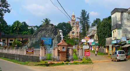
Country India Telephone code 04828 Area code 04828 Local time Friday 4:25 AM | Time zone IST (UTC+5:30) Population 27,127 (2012) Nearest city Palai | |
 | ||
PIN 686507 (Kanjirappally Head Post Office) Weather 24°C, Wind NE at 0 km/h, 86% Humidity University Amal Jyothi College of Engineering, Kottayam | ||
Puthenangady kanjirappally kottayam district kerala india
Kanjirappally is a taluk and a town in Kottayam district situated about 38 km (24 mi) away from the district capital, in the state of Kerala, India. National Highway (old NH 220 Kollam - Theni now NH 183) connects Kanjirapally to major nearest cities. Kanjirappally, also known as the Door of Highrange since it is the geographic entrance to the 'Malanad' or the Hill country of Kerala, which extends to Idukki district and then to Tamil Nadu.
Contents
- Puthenangady kanjirappally kottayam district kerala india
- Map of Kanjirappally Kerala
- Rosemary ente kanjirappally special interview
- Economy
- Film shooting
- Syrian Catholic settlements
- Climate
- Religion
- Transportation
- Administration
- Celebrities
- Education
- Engineering colleges
- Arts and science colleges
- References
Map of Kanjirappally, Kerala
Rosemary ente kanjirappally special interview
Economy
Rubber plantations are a major source of income for the local population. The place has a large population of Syrian Catholic Christians. The Christians of Kanjirapally are known to be the earliest agrarian group in Kerala to have switched to plantation agriculture by the beginning of the 20th century. The place is therefore home to many legendary Syrian Christian families of Kerala, who owe their affluence to plantation agriculture, particularly Rubber.
Film shooting
Since the early 1980s, Kanjirapally has won a special place in the hearts of Keralites, through scores of Malayalam movies that depict the region as a pocket of Christian affluence. The term 'Achayan', which is colloquially used among the Nasranis of Central Travancore, has always been synonymous with Kanjirapally.
Syrian Catholic settlements
The Syrian Christian colonization of Kanjirappally had a profound impact on the history of commerce and agriculture in these parts. The Christians claim their roots from early settlements at Nilackal or Chayal on the banks of Pamba River, in the Sabarimala Hills of eastern Kerala. There is also a strong belief that the flourishing Christian community here was founded by Saint Thomas the Apostle himself. The place was in the forest recesses far away from seats of power. Nilackal became an important depot for spices like pepper, cardamom etc. and the Christians were engaged in this lucrative trade as procures and sorters. Following a catastrophic event in the mid 14th century, the Christian inhabitants of Nilackal fled the region, a large section of whom migrated to the present day Kanjirapally, which is 30 miles Northwest of the ancient town. The direct descendants of these settlers constructed the Pazhayapally (meaning the 'Old Church') in the middle of the town. Following the agrarian expansion of the 19th century, the Syrian Christians spread to places around Kanjirapally, such as Manimala, Ponkunnam, Erumely, Mundakayam and their surrounding regions, clearing forests and setting up farms.
Climate
Kanjirapally boasts the highest number of rainy days per year in India, that is 163. The place receives the highest amount of Summer rains, Winter rains and Northeast Monsoons (Thulaam Mazha) in Kerala, making it one of the very few places in India enjoying equatorial rainforest type climate, with no distinct dry season. The well distributed rainfall pattern of Kanjirapally is the primary reason for the phenomenon of high yield of latex from Rubber plantations in and around the town. The average annual rainfall is 4156 mm.
Religion
Kanjirappally is an old town that boasts of its religious harmony. The population in the town area is a mixture of Syrian Christians, Muslims, and Hindus. However, the Syrian Christians constitute the vast majority in the interior regions of Kanjirapally, where agriculture thrives. They also make up the dominant socio-economic community of the region.
Transportation
The K. K. Road (NH 183: Kollam-Theni) (Kottayam-Kumily Road) connects Kanjirapally to major nearest cities like Mundakkayam (16 km), Kottayam (38 km), Kuttikkanam (34 km), Kumily (72 km) and Ponkunnam (5 km).
The nearest international airport is Cochin International Airport in Nedumbassery, the nearest railway station is in Kottayam and Changanassery and the nearest KSRTC bus station is in Ponkunnam. The nearest Medical College is at Kottayam. A railway station is expected to be built at Kanjirappally as a part of Angamaly-Sabarimala rail route in future.
Administration
Kanjirappally assembly constituency is part of Pathanamthitta (Lok Sabha constituency). Previously it was part of Muvattupuzha (Lok Sabha constituency). Most of the local administration offices like PWD, Railway Reservation Counter, Employment Exchange, Taluk offices etc. are now located in the recently constructed Mini Civil Station.
