
Length 590.6 km | ||
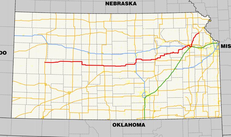 | ||
K-4 is the longest designated state highway in Kansas traversing from north of Scott City at US-83 to US-59 near Nortonville in northeast Kansas. A segment of the highway in Saline County overlaps Interstate 135, and a section in Topeka runs concurrent with Interstate 70.
Contents
Western Kansas
K-4 roughly parallels K-96 between its western terminus and the K-14 junction in Rice County. The route begins in rural Scott County at an intersection with U.S. Route 83. Sixteen miles (26 km) east of here, it passes through the town of Healy. Six miles (10 km) further east, it has a 2 mi (3 km) concurrency with K-23. K-4 next serves the towns of Shields, Utica, Arnold, and Ransom, before intersecting US-283. After passing through Brownell, K-4 serves as the southern terminus of K-147. K-4 then turns southward to bisect McCracken before turning to the east to cross US-183 in La Crosse, the county seat of Rush County.
From La Crosse, K-4 heads due east, running through Otis as it approaches the Barton County line. It then meets US-281 in a T-intersection and begins an overlap with it. This overlap carries the two routes through to Hoisington, where they split up. K-4 then runs through Redwing and Claflin. East of Claflin, K-4 has a full folded diamond interchange with K-156. K-4 bypasses Bushton (which can be accessed via K-171) and cuts through Frederick before having a junction with K-14. It then runs just north of Geneseo and along the Rice/Ellsworth County line. The highway then moves fully into Ellsworth County, where it meets the south end of K-141.
Central Kansas
K-4 then enters McPherson County. It runs just north of Marquette, which lies at the opposite end of the former K-175, before heading towards downtown Lindsborg. In Lindsborg, K-4 encounters former US-81 Business, before heading north out of town and into Saline County. It then heads north in a concurrency with Interstate 135/US-81. K-4 merges onto the northbound Interstate at Exit 78, then splits off again at Exit 82. It then bypasses Assaria to the west before heading north to spawn a child route, K-104, after which it turns due east once again. K-4 next serves Gypsum and Carlton before intersecting K-15. It then continues east to Hope, serving as the southern terminus for K-43 in the latter.
K-4 then runs north of the town of Herington. Near Herington, K-4 junctions with two north–south highways that connect through town: K-218 and US-77. Also near Herington, K-4 gets within two miles (3 km) of US-56, but never actually intersects it. It then zig-zags northeast through Latimer before turning north at the northern end of K-149. K-4 then runs through White City and Dwight, where K-4 serves as a terminus yet again, this time for K-57. K-4 then has a brief concurrency with K-177, and 14 miles (23 km) after that concurrency ends, it forms another one with K-99. The two routes split apart in Eskridge. K-4 then serves Dover before merging onto eastbound Interstate 70 at Exit 353.
I-70 and K-4 (which are also concurrent with US-40 at this point) then enter the state capital, Topeka. The next interchange, Exit 355, is for Interstate 470 and is also where US-75 joins, forming a four-way overlap. US-75 then splits off on its own freeway at Exit 358A. The freeway then snakes around downtown Topeka. At the East Topeka interchange, the Kansas Turnpike joins the mainline, and I-70 merges onto it. US-40 and K-4 split off to the north to their own freeway.
East of Topeka
US-40 splits off K-4 at the first interchange north of I-70. K-4 then downgrades to a Super-2 freeway. The next interchange (with Seward Avenue) serves Philip Billard Municipal Airport. K-4 then crosses the Kansas River and merges onto the US-24 expressway before splitting off again at the next interchange. K-4 then returns to its normal rural highway configuration.
K-4 then curves southeast of Meriden (K-245 exists to connect the town to K-4). It then passes the west end of K-92 near Rock Creek. It then has a brief overlap with K-16 in the Valley Falls area. K-4 then angles northeast to pass just south of Nortonville. Finally, K-4 comes to an end at US-59 just southeast of Nortonville.
Bannered highways
Alternate K-4 serves Nortonville. It goes north from K-4, passes through Nortonville, then turns east at an intersection with US-159. The two highways turn east together and both end at an intersection east of Nortonville at US-59.
Original alignment
Originally, K-4 began at then-K-1 (now U.S. Route 183) in La Crosse. From La Crosse, K-4 followed its current alignment east to Herington. Past Herington, K-4 continued east on modern U.S. Route 56 to Council Grove, where it then followed a series of now unnumbered roadways to rejoin its present alignment at Eskridge. From Eskridge to west of Topeka, K-4 was identical to its current routing; however, at the intersection of SW Auburn Road and SW 21st Street, where K-4 currently continues north to access Interstate 70, K-4 turned east, following SW 21st Street into Topeka. At Topeka Boulevard, K-4 turned north, following the street out of the city.
K-4 remained on Topeka Boulevard north to an intersection with NE 82nd Street south of the Shawnee–Jackson county line. K-4 headed east on 82nd to Meriden, where it rejoined its modern routing near the modern intersection of K-4 and Butler Road east of Meriden. From Meriden to Valley Falls, K-4 did not follow its current alignment. Instead of bypassing Rock Creek, K-4 continued into Rock Creek on (what is now) Rock Creek Rd. K-4 continued North and curved to the east on 114th. From there K-4 continued east until Decatur Rd. where it curved back to the North. From there it continued north until curving back to the east on 134th, continuing on to Edwards Rd. where it curved to the North. From there K-4 went north to 142nd before curving back to the east. From here it continued onto Valley Falls.
Past Valley Falls, K-4 followed 162nd Street and modern K-16 east to Osage Road, where the route intersected K-16. At the time, K-4 and K-16 overlapped northward along Osage Road to Nortonville, then followed the modern alignments of U.S. Route 159 and K-116 to Cummings. Between Cummings and Atchison, K-4 and K-16 zig-zagged across several roadways surrounding the current alignment of U.S. Route 59 before joining the modern routing of US-59 just west of Atchison. In Atchison, K-16 split from K-4 and headed northward on modern K-7 while K-4 continued to the Missouri state line on current US-59.
From Scott City to La Crosse, modern K-4 was designated K-52. From Herington to Eskridge, as well as between Topeka and Meriden, the modern routing of K-4 was unnumbered. Past Meriden, most of K-4's current roadway was unbuilt.
Between 1968 and 1997, K-4 was aligned along US-75 between I-70/US-40 and US-24 and then US-24 in Topeka. In 1997, the Oakland Expressway, serving eastern Topeka, was opened and K-4 gained its current route through Topeka.