
Length 50.2 km | ||
 | ||
Counties | ||
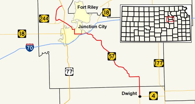
K-57 is a 31.2-mile-long (50.2 km) state highway in the U.S. state of Kansas. It is a north-south highway that connects Junction City to Milford Lake, as well as serving as a southeasterly connection to Council Grove. The highway's mileposts are signed the wrong way; generally the mileage starts at the southern or western terminus. However, the mileposts begin at the northern terminus.
Contents
Route description
K-57 begins at US-77 east of Milford Lake, where it heads southwest towards the reservoir. It enters Milford State Park and traverses the dam at the lake. The highway meets a spur of K-244, and turns southeast before meeting K-244. K-57 intersects US-77 once again, and enters Junction City as Jackson Street. It turns east at 18th Street near Junction City Municipal Airport. After traveling east 4 blocks, the highway turns onto Washington Street, where it travels south for a mile (1.6 km) before turning east onto 6th Street and exiting the city. The portion between US-77 and 6th street is also signed as Alternate US-77. K-57 approaches Grandview Plaza, where it crosses the Smoky Hill River at the western city limit. The highway passes through the southern edge of town while paralleling I-70. East of the town, it turns southeast, and passes under I-70 with a diamond interchange. K-57 travels southeast through rural Geary County, winding through the Flint Hills. The highway enters Morris County 2 miles (3.2 km) north of Dwight, and meets its southern terminus in the town at K-4.
History
K-57 first appeared on the map in 1932. The highway was once much longer, and spanned a large portion of eastern Kansas. The southern terminus was at the Missouri border southeast of Pittsburg on what is current-day K-171. Much of the old alignment is now county-owned roads, and after being moved to other, overlapping highways over the years, last appeared on the 2003-2004 map.