
Norse name Herrey Area rank 7 Population 5,058 (2003) | OS grid reference NR950359 Area 432 km² | |
 | ||
Gaelic name Eilean Arainn (help·info) Meaning of name Possibly Brythonic for "high place" Island groups British Isles, Islands of the Clyde Points of interest Brodick Castle, Goat Fell, Holy Isle, Beinn Tarsuinn, Eas a’ Chrannaig | ||
Old photographs lamlash isle of arran scotland
Arran or the Isle of Arran (/ˈærən/; Scottish Gaelic: Eilean Arainn [elan ˈarɪɲ]), at 432 square kilometres (167 sq mi), is the largest island in the Firth of Clyde and the seventh largest Scottish island. It is in the unitary council area of North Ayrshire. In the 2011 census it had a resident population of 4,629. Though culturally and physically similar to the Hebrides, it is separated from them by the Kintyre peninsula. It is divided into highland and lowland areas by the Highland Boundary Fault and has been described as a "geologist's paradise".
Contents
- Old photographs lamlash isle of arran scotland
- Map of Isle of Arran UK
- Lastmarvin cottage isle of arran scotland
- Etymology
- Geography and geology
- Villages
- Surrounding islands
- Climate
- Prehistory
- Gaels Vikings and the medieval era
- Modern era
- Gaelic
- Local government
- Health services
- Transport
- Economy
- Culture
- Natural history
- Notable residents
- References
Map of Isle of Arran, UK
Arran has been continuously inhabited since the early Neolithic period, and numerous prehistoric remains have been found. From the 6th century onwards, Goidelic-speaking peoples from Ireland colonised it and it became a centre of religious activity. During the troubled Viking Age, Arran became the property of the Norwegian crown, until formally absorbed by the kingdom of Scotland in the 13th century. The 19th century "clearances" led to significant depopulation and the end of the Gaelic language and way of life. The economy and population have recovered in recent years, the main industry being tourism. There is a diversity of wildlife, including three species of tree endemic to the area.
Lastmarvin cottage isle of arran scotland
Etymology
Most of the islands of Scotland have been occupied by the speakers of at least four languages since the Iron Age, and many of the names of these islands have more than one possible meaning as a result. Arran is therefore not unusual in that the derivation of the name is far from clear. Mac an Tàilleir (2003) states that "it is said to be unrelated to the name Aran in Ireland" (which means "kidney shaped", cf Irish ára "kidney"). Unusually for a Scottish island, Haswell-Smith (2004) offers a Brythonic derivation and a meaning of "high place" which at least corresponds with the geography—Arran is significantly loftier than all the land that immediately surrounds it along the shores of the Firth of Clyde.
Any other Brythonic place names that may have existed were later replaced on Arran as the Goidelic-speaking Gaels spread from Ireland via their adjacent kingdom of Dál Riata. During the Viking Age the island, along with the vast majority of the Scottish islands, became the property of the Norwegian crown, at which time it may have been known as "Herrey" or "Hersey". As a result of this Norse influence, many current place names on Arran are of Viking origin.
Geography and geology
The island lies in the Firth of Clyde between Ayr and Ardrossan, and Kintyre. The profile of the north Arran hills as seen from the Ayrshire coast is a well-known sight referred to as the "Sleeping Warrior" due to its resemblance to a resting human figure. The highest of these hills is Goat Fell at 873.5 metres (2,866 ft). There are three other Corbetts, all in the north east: Caisteal Abhail, Cìr Mhòr and Beinn Tarsuinn. Beinn Bharrain is the highest peak in the north west at 721 metres (2,365 ft).
The largest valley on the island is Glen Iorsa to the west, whilst narrow Glen Sannox (Gaelic: Gleann Shannaig) and Glen Rosa (Gaelic: Gleann Ròsa) to the east surround Goat Fell. The terrain to the south is less mountainous, although a considerable portion of the interior lies above 350 metres (1,150 ft), and A' Chruach reaches 512 metres (1,680 ft) at its summit. There are two other Marilyns in the south, Tighvein and Beinn Bhreac.
Arran is sometimes referred to as "Scotland in miniature", as it is divided into "Highland" and "Lowland" areas by the Highland Boundary Fault which runs northeast to southwest across Scotland. Arran is a popular destination for geologists, who come to see intrusive igneous landforms such as sills and dykes as well as sedimentary and metasedimentary rocks ranging in age from Precambrian to Mesozoic.
Most of the interior of the northern half of the island is taken up by a large granite batholith that was created by substantial magmatic activity around 58 million years ago in the Paleogene period. This comprises an outer ring of coarse granite and an inner core of finer grained granite, which was intruded later. This granite was intruded into the Late Proterozoic to Cambrian metasediments of the Dalradian Supergroup. Other Paleogene igneous rocks on Arran include extensive felsic and composite sills in the south of the island, and the central ring complex, an eroded caldera system surrounded by a near-continuous ring of granitic rocks.
Sedimentary rocks dominate the southern half of the island, especially Old and New Red Sandstone. Some of these sandstones contain fulgurites - pitted marks that may have been created by Permian lightning strikes. Large aeolian sand dunes are preserved in Permian sandstones near Brodick, showing the presence of an ancient desert. Within the central complex are subsided blocks of Triassic sandstone and marl, Jurassic shale, and even a rare example of Cretaceous chalk. During the 19th century barytes was mined near Sannox. First discovered in 1840, nearly 5,000 tons were produced between 1853 and 1862. The mine was closed by the 11th Duke of Hamilton on the grounds that it "spoiled the solemn grandeur of the scene" but was reopened after the First World War and operated until 1938 when the vein ran out.
Visiting in 1787, the geologist James Hutton found his first example of an unconformity to the north of Newton Point near Lochranza, which provided evidence for his Plutonist theories of uniformitarianism and about the age of the Earth. This spot is one of the most famous places in the study of geology.
The Pleistocene glaciations almost entirely covered Scotland in ice, and Arran's highest peaks may have been nunataks at this time. After the last retreat of the ice at the close of the Pleistocene epoch sea levels were up to 70 metres (230 ft) lower than at present and it is likely that circa 14,000 BP the island was connected to mainland Scotland. Sea level changes and the isostatic rise of land makes charting post-glacial coastlines a complex task, but it is evident that the island is ringed by post glacial raised beaches. King's Cave on the south west coast is an example of an emergent landform on such a raised beach. This cave, which is over 30.5 metres (100 ft) long and up to 15.3 metres (50 ft) high, lies well above the present day sea level. There are tall sea cliffs to the north east including large rock slides under the heights of Torr Reamhar, Torr Meadhonach and at Scriden (An Scriodan) at the far north end of the island.
Villages
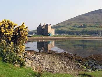
Arran has several villages, mainly around the shoreline. Brodick (Old Norse: "broad bay") is the site of the ferry terminal, several hotels, and the majority of shops. Brodick Castle is a seat of the Dukes of Hamilton. Lamlash, however, is the largest village on the island and in 2001 had a population of 1,010 compared to 621 for Brodick. Other villages include Lochranza, in which the Blackwood-Davidson family had their principal seat, Lochranza Castle and Catacol in the north, Corrie in the north east, Blackwaterfoot in the south west, Kildonan in the south and Whiting Bay in the south east.
Surrounding islands
Arran has three smaller satellite islands: Holy Isle lies to the east opposite Lamlash, Pladda is located off Arran's south coast and tiny Hamilton Isle lies just off Clauchlands Point 1.2 kilometres (0.75 mi) north of Holy Isle. Eilean na h-Àirde Bàine off the south west of Arran at Corriecravie is a skerry connected to Arran at low tide.
Other islands in the Firth of Clyde include Bute, Great Cumbrae and Inchmarnock.
Climate
The influence of the Atlantic Ocean and the Gulf Stream create a mild oceanic climate. Temperatures are generally cool, averaging about 6 °C (43 °F) in January and 14 °C (57 °F) in July at sea level. The southern half of the island, being less mountainous, has a more favourable climate than the north, and the east coast is more sheltered from the prevailing winds than the west and south.
Snow seldom lies at sea level and frosts are less frequent than on the mainland. As in most islands of the west coast of Scotland, annual rainfall is generally high at between 1,500 mm (59 in) in the south and west and 1,900 mm (75 in) in the north and east. The mountains are wetter still with the summits receiving over 2,550 mm (100 in) annually. May and June are the sunniest months, with upwards of 200 hours of bright sunshine being recorded on average.
Prehistory
Arran has a particular concentration of early Neolithic Clyde Cairns, a form of Gallery grave. The typical style of these structures is a rectangular or trapezoidal stone and earth mound that encloses a chamber lined with larger stone slabs. Pottery and bone fragments found inside the chambers suggest they were used for interment and some have forecourts, which may have been an area for public display or ritual. There are two good examples in Monamore Glen west of the village of Lamlash, and similar structures called the Giants' Graves above Whiting Bay. There are numerous standing stones dating from prehistoric times, including six stone circles on Machrie Moor (Gaelic: Am Machaire).
Pitchstone deposits on the island were used locally for making various items in the Mesolithic era. In the Neolithic and the Early Bronze Age pitchstone from the Isle of Arran or items made from it were transported around Britain.
Several Bronze Age sites have been excavated, including "Ossian's Mound" near Clachaig and a cairn near Blackwaterfoot that produced a bronze dagger and a gold fillet. Torr a' Chaisteal Dun in the south west near Sliddery is the ruin of an Iron Age fortified structure dating from about AD 200. The original walls would have been 3 metres (9.8 ft) or more thick and enclosed a circular area about 14 metres (46 ft) in diameter.
Gaels, Vikings and the medieval era
An ancient Irish poem called Agalllamh na Senorach, first recorded in the 13th century, describes the attractions of the island.
Merry hinds are on her hills,Juicy berries are there for food,Refreshing water in her streams,Nuts in plenty in the wood.The monastery of Aileach founded by St. Brendan in the 6th century may have been on Arran and St. Molaise was also active, with Holy Isle being a centre of his activities. The caves below Keil Point (Gaelic: Rubha na Cille) contain a slab which may have been an ancient altar. This stone has two petrosomatoglyphs on it, the prints of two right feet, said to be of Saint Columba.
In the 11th century Arran became part of the Sodor (Old Norse: 'Suðr-eyjar'), or South Isles of the Kingdom of Mann and the Isles, but on the death of Godred Crovan in 1095 all the isles came under the direct rule of Magnus III of Norway. Lagman (1103–1104) restored local rule. After the death of Somerled in 1164 Arran and Bute were ruled by his son Angus. In 1237, the Scottish isles broke away completely from the Isle of Man and became an independent kingdom. After the indecisive Battle of Largs between the kingdoms of Norway and Scotland in 1263, Haakon Haakonsson, King of Norway reclaimed Norwegian lordship over the "provinces" of the west. Arriving at Mull, he rewarded a number of his Norse-Gaelic vassals with grants of lands. Bute was given to Ruadhri and Arran to Murchad MacSween. Following Haakon's death later that year Norway ceded the islands of western Scotland to the Scottish crown in 1266 by the Treaty of Perth. A substantial Viking grave has been discovered near King's Cross south of Lamlash, containing whalebone, iron rivets and nails, fragments of bronze and a 9th-century bronze coin, and another grave of similar date nearby yielded a sword and shield. Arran was also part of the medieval Bishopric of Sodor and Man.
On the opposite side of the island near Blackwaterfoot is the King's Cave (see above) where Robert the Bruce is said to have taken shelter in the 14th century. Bruce returned to the island in 1326, having earlier granted lands to Fergus MacLouis for assistance rendered during his time of concealment there. Brodick Castle played a prominent part in the island's medieval history. Probably dating from the 13th century, it was captured by English forces during the Wars of Independence before being taken back by Scottish troops in 1307. It was badly damaged by action from English ships in 1406 and sustained an attack by John of Islay, the Lord of the Isles in 1455. Originally a seat of the Clan Stewart of Menteith it passed to the Boyd family in the 15th century. For a short time during the reign of King James V in the 16th century the Isle of Arran was under the regency of Robert Maxwell, 5th Lord Maxwell.
Modern era
At the commencement of the Early modern period James, 2nd Lord Hamilton became a privy counsellor to his first cousin, James IV of Scotland and helped to arrange his marriage to Princess Margaret Tudor of England. As a reward he was created Earl of Arran in 1503. The local economy for much of this period was based on the run rig system, the basic crops being oats, barley and potatoes. The population slowly grew to about 6,500. In the early 19th century Alexander, 10th Duke of Hamilton (1767–1852) embarked on a programme of clearances that had a devastating effect on the island's population. These "improvements" typically led to land that had been rented out to as many as 27 families being converted into a single farm. In some cases, land was promised in Canada for each adult emigrant male. In April 1829, for example, 86 islanders boarded the brig Caledonia for the two-month journey, half their fares being paid for by the Duke. However, on arrival in Quebec only 41 hectares (100 acres) was made available to the heads of extended families. Whole villages were removed and the Gaelic culture of the island devastated. The writer James Hogg wrote: "Ah! Wae's me. I hear the Duke of Hamilton's crofters are a' gaun away, man and mother's son, frae the Isle o' Arran. Pity on us!". A memorial to this has been constructed on the shore at Lamlash, paid for by a Canadian descendant of the emigrants.
On 10 August 1941 a RAF Consolidated B-24 Liberator LB-30A AM261 was flying from RAF Heathfield in Ayrshire to Gander International Airport in Canada. However, the B-24 crashed into the hillside of Mullach Buidhe north of Goat Fell where all 22 passengers and crew died.
Arran's resident population was 4,629 in 2011, a decline of just over 8% from the figure of 5,045 recorded in 2001 against a background of Scottish island populations as a whole growing by 4% to 103,702 for the same period.
Gaelic
Gaelic was still spoken widely on Arran at the beginning of the 20th century. The 1901 Census reported 25-49% Gaelic speakers on the eastern side of the island and 50-74% on the western side of the island. By 1921 the percentage for the whole island had dropped to less than 25%. From then onwards, the number of speakers fell into the vague 0-24.9% bracket. However, Nils Holmer quotes the Féillire (a Gaelic almanack) reporting 4,532 inhabitants on the island in 1931 with 605 Gaelic speakers, showing that Gaelic had declined to about 13% of the population. It continued to decline until the last native speakers of Arran Gaelic died in the 1990s. Current-day Gaelic speakers on Arran originate from other areas in Scotland. In 2011, 2.0% of Arran residents age 3 and over could speak Gaelic.
Arran Gaelic is reasonably well documented. Holmer carried out fieldwork on the island in 1938, reporting Gaelic being spoken by "a fair number of old inhabitants". He interviewed 53 informants from various locations and his description of the dialect, The Gaelic of Arran, was published in 1957 and runs to 211 pages of phonological, grammatical and lexical information. The Survey of the Gaelic Dialects of Scotland, which collected Gaelic dialect data in Scotland between 1950 and 1963 also interviewed 5 native speakers of Arran Gaelic.
The Arran dialect falls firmly into the southern group of Gaelic dialects (referred to as the "peripheral" dialects in Celtic studies) and thus shows:
The most unusual feature of Arran Gaelic is the /w/ glide after labials before a front vowel, e.g. maith 'good' /mwɛh/ (normally /mah/).
Mac an Tàilleir (2003) notes that the island has a poetic name Arainn nan Aighean Iomadh - "Arran of the many stags" and that a native of the island or Arainneach is also nicknamed coinean mòr in Gaelic, meaning "big rabbit". Locally, Arainn was pronounced /ɛɾɪɲ/.
Local government
From the seventeenth century to the late twentieth century Arran was part of the County of Bute. After the 1975 reorganisation of local government Arran became part of the district of Cunninghame in Strathclyde Region.
This two-tier system of local government lasted until 1996 when the Local Government etc. (Scotland) Act 1994 came into effect, abolishing the regions and districts and replacing them with 32 unitary authorities. Arran is now in the North Ayrshire council area, along with some of the constituent islands of the old County of Bute.
For some statistical purposes Arran is within the registration county of Ayrshire and for ceremonial purposes within the lieutenancy area of Ayrshire and Arran.
In the House of Commons, since 2005 Arran has been part of the Ayrshire North and Arran constituency, represented since 2015 by Patricia Gibson of the SNP. It was previously part of the constituency of Cunninghame North from 1983 to 2005, and of Ayrshire North and Bute from 1918 to 1983.
In the Scottish Parliament, Arran is part of the constituency of Cunninghame North, currently represented by Kenneth Gibson of the Scottish National Party (SNP). Labour held the seat until 2007, when the SNP gained it with a majority of just 48, making it the most marginal seat in Holyrood until 2011 when the SNP significantly increased their majority to 6117 over the Labour Party.
Health services
NHS Ayrshire and Arran is responsible for the provision of health services for the island. Arran War Memorial Hospital is a 17-bed acute hospital at Lamlash. The Arran Medical Group provides primary care services and supports the hospital. The practice is based at Brodick Health Centre and has three base surgeries and four branch surgeries.
Transport
The Isle of Arran is connected to the Scottish mainland by two Caledonian MacBrayne ferries, MV Caledonian Isles from Brodick to Ardrossan and MV Catriona (in summertime only) from Lochranza to Claonaig. The MV Isle of Arran provides additional sailings from Brodick to Ardrossan during the summer season. Summer day trips are also available on board the paddle steamer PS Waverley and a summertime service operated by a local resident connects Lamlash to the neighbouring Holy Isle.
There are three roads on the island. The 90 kilometres (56 mi) long coast road circumnavigates the island. In 2007, a 48 kilometres (30 mi) stretch of this road, previously designated as the A841, was de-classified to a 'C' road. Travelling south from Whiting Bay, the C147 goes round the south coast continuing north up the west coast of the island to Lochranza. At this point the road becomes the A841 down the east coast back to Whiting Bay.
At one point the coast road ventures inland, this is to climb the 200 metres (660 ft) pass at the Boguillie between Creag Ghlas Laggan and Caisteal Abhail, located between Sannox and Lochranza.
The other two roads run across from the east to the west side of the island. The main cross-island road is the 19 kilometres (12 mi) long B880 from Brodick to Blackwaterfoot called "The String", which climbs over Gleann an t-Suidhe. About 10 kilometres (6 mi) along the B880 from Brodick, a minor road branches off to the right to Machrie. The single track road "The Ross" runs 15 kilometres (9 mi) from Lamlash to Lagg and Sliddery via Glen Scorodale (Gaelic: Gleann Sgoradail).
The island can be explored using public transport using a bus service operated by Stagecoach.
Economy
The main industry of the island is tourism, one of the main attractions being the imposing Brodick Castle, owned by the National Trust for Scotland. The Auchrannie Resort, which contains 2 hotels, 3 restaurants and 2 leisure complexes, is one of biggest employers on the island. Local businesses include the Arran Distillery, which was opened in 1995 in Lochranza, and Arran Aromatics, which produces a range of toiletries. The island has a number of golf courses including the 12 hole Shiskine links course which was founded in 1896.
Farming and forestry are other important industries. 2008 plans for a large salmon farm holding 800,000 or more fish in Lamlash Bay have been criticised by the Community of Arran Seabed Trust. They feared the facility could jeopardise Scotland's first marine No Take Zone, which was announced in September 2008.
The Arran Brewery is a microbrewery founded in March 2000 in Cladach, near Brodick. The brewery produces 8 regular cask and bottled beers. The wheat beer, Arran Blonde (5.0% abv) is the most popular brand and others include Arran Dark and Arran Sunset, with a seasonal ale called Fireside only brewed in winter. The brewery is open for tours, with tastings in the shop. The business went into liquidation in May 2008 and was subsequently sold to Marketing Management Services International Ltd. in June 2008. The brewery is now back in production and the beers widely available in Scotland.
Culture
The Scottish Gaelic dialect of Arran died out when the last speaker Donald Craig died in the 1970s. However, there is now a Gaelic House in Brodick, set up at the end of the 1990s. Brodick Castle features on the Royal Bank of Scotland £20 note and Lochranza Castle was used as the model for the castle in The Adventures of Tintin adventure The Black Island.
Arran has one newspaper, The Arran Banner. It was listed in the Guinness Book of Records in November 1984 under the title of "local newspaper which achieves the closest to a saturation circulation in its area". The entry reads "The Arran Banner, founded in 1974, has a readership of more than 97 per cent in Britain’s seventh largest off-shore island". There is also an online monthly publication called Voice for Arran that relies mainly on articles contributed by community members.
In 2010 an "Isle of Arran" version of the game Monopoly was launched.
The knitting style used to create Aran sweaters is often mistakenly associated with the Isle of Arran rather than the Irish Aran Islands.
Natural history
The island has three endemic species of tree, the Arran whitebeams. These trees are the Scottish or Arran whitebeam (Sorbus arranensis), the bastard mountain ash or cut-leaved whitebeam (Sorbus pseudofennica) and the Catacol whitebeam (Sorbus pseudomeinichii). If rarity is measured by numbers alone they are amongst the most endangered tree species in the world. They are protected in Glen Diomhan off Glen Catacol, at the north end of the island by a partly fenced off national nature reserve, and are monitored by staff from Scottish Natural Heritage. Only 236 Sorbus pseudofennica and 283 Sorbus arranensis were recorded as mature trees in 1980. They are typically trees of the mountain slopes, close to the tree line. However, they will grow at lower altitudes, and are being preserved within Brodick Country Park.
Over 200 species of bird have been recorded on Arran including black guillemot, eider, peregrine falcon and the golden eagle. In 1981 there were 28 ptarmigan on Arran, but in 2009 it was reported that extensive surveys had been unable to record any. Similarly, the red-billed chough no longer breeds on the island.
Red deer are numerous on the northern hills, and there are populations of red squirrel, badger, otter, adder and common lizard. Offshore there are harbour porpoises, basking sharks and various species of dolphin.
The northern part of Lamlash Bay became a Marine Protected Area and a "no take zone" under the terms of the Marine (Scotland) Act 2010 which means that no fish or shellfish may be taken in the designated area. In 2014 the Scottish Government created Scotland's first Marine Conservation Order in order to protect delicate maerl beds off south Arran after fishermen breached a voluntary agreement not to trawl in the vicinity.