
 | ||
This is a list of islands of Scotland, the mainland of which is part of the island of Great Britain. Also included are various other related tables and lists. The definition of an offshore island used in this list is "land that is surrounded by seawater on a daily basis, but not necessarily at all stages of the tide, excluding human devices such as bridges and causeways".
Contents
- Demographics
- Larger islands
- Freshwater islands
- Smaller offshore islands
- Small archipelagos
- Former islands
- Bridged islands
- Tidal islands and tombolos
- Complex islands
- Castle islands
- Holy islands
- Islands named after people
- Places called island etc that are not islands
- Other elements
- Islands named after mainland areas
- Cranngs
- References
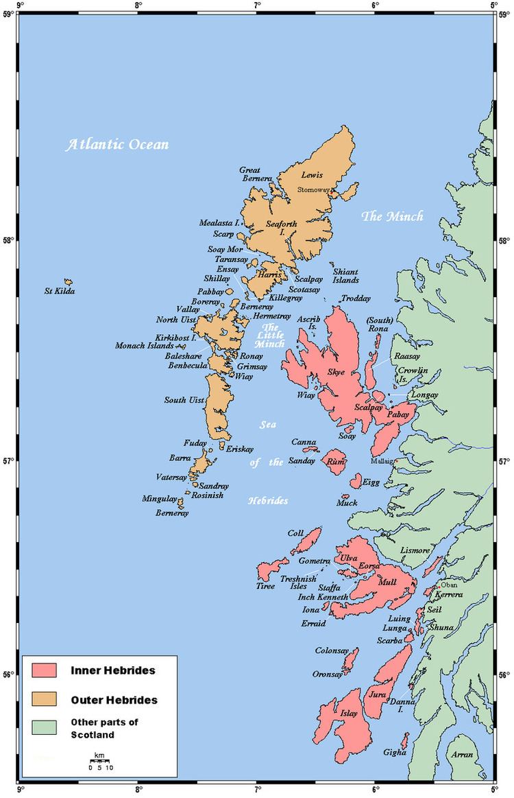
Scotland has over 790 offshore islands, most of which are to be found in four main groups: Shetland, Orkney, and the Hebrides, sub-divided into the Inner Hebrides and Outer Hebrides. There are also clusters of islands in the Firth of Clyde, Firth of Forth, and Solway Firth, and numerous small islands within the many bodies of fresh water in Scotland including Loch Lomond and Loch Maree.
Many of these islands are swept by strong tides, and the Corryvreckan tide race between Scarba and Jura is one of the largest whirlpools in the world. Other strong tides are to be found in the Pentland Firth between mainland Scotland and Orkney, and another example is the "Grey Dog" between Scarba and Lunga. The geology and geomorphology of the islands is varied. Some, such as Skye and Mull are mountainous, while others like Tiree and Sanday are relatively low lying. Many have bedrock made from ancient Archaean Lewisian Gneiss which was formed 3 billion years ago; Shapinsay and other Orkney islands are formed from Old Red Sandstone, which is 400 million years old; and others such as Rùm from more recent Tertiary volcanoes.
The largest island is Lewis and Harris which extends to 2,179 square kilometres, and there are a further 200 islands which are greater than 40 hectares in area. Of the remainder, several such as Staffa and the Flannan Isles are well known despite their small size. Some 94 Scottish islands are permanently inhabited, of which 89 are offshore islands and between 2001 and 2011 Scottish island populations as a whole grew by 4% to 103,702.
The culture of the islands has been affected by the successive influences of Celtic, Norse and English speaking peoples and this is reflected in names given to the islands. Most of the Hebrides have names with Scots Gaelic derivations, whilst those of the Northern Isles tend to be derived from the Viking names. A few have Brythonic, Scots and even perhaps pre-Celtic roots. A feature of modern island life is the low crime rate and they are considered to be amongst the safest places to live in Britain. Orkney was rated as the best place to live in Scotland in both 2013 and 2014 according to the Halifax Quality of Life survey.
Rockall is a small rocky islet in the North Atlantic which was declared part of Scotland by the Island of Rockall Act 1972. However, the legality of the claim is disputed by the Republic of Ireland, Denmark and Iceland and it is probably unenforceable in international law.
Demographics
The 2011 census records 94 Scottish islands as having a usually resident population of which 89 are offshore islands. There are however various complications with both the definitions of an "island" and occasional habitation and the National Records of Scotland also list a further 17 islands that were inhabited in 2001 but not 2011, or are "included in the NRS statistical geography for inhabited islands but had no usual residents at the time of either the 2001 or 2011 censuses". There are a small number of other islands that are evidently inhabited but which are not recorded in this list.
The local government council areas with the most inhabited islands are Argyll and Bute with 23, Orkney with 20, Shetland with 16 and Highland and Comhairle nan Eilean Siar with 14 each. There are also three in North Ayrshire and one each in Fife, Perth and Kinross, Stirling and West Dunbartonshire. The last three named plus two islands in Argyll and Bute are freshwater rather than offshore.
In the past many smaller islands that are uninhabited today had permanent populations. Losses were severe in many areas during the 19th century when islands such as Pabbay and Fuaigh Mòr were subject to forcible evictions during the Highland Clearances. Mass emigration from the Hebridean islands was at its height in the mid-19th century but it commenced as early as the 1770s in some areas. The crofting counties held 20% of Scotland's population in 1755 but by 1961 this figure had declined to 5%. Other examples include Mingulay, Noss and the St Kilda archipelago, which were abandoned during the course of the 20th century. Declines have been particularly significant in the more remote outlying islands, some of which remain vulnerable to ongoing losses.
The following table shows population trends for the ten most populous islands as of the last census. The overall trends are typically growth in populations in the early part of the modern period, followed by declines from the mid 19th century onwards. In every case except Orkney the highest population was recorded prior to 1932 and the lowest post-industrial revolution figure after 1960. Subsequently, there has been modest growth overall, although some islands are continuing to show a decline. Between 1991 and 2001, the population of the islands as a whole fell by 3% to 99,739, although there were 35 islands whose population increased. By contrast, between 2001 and 2011 Scottish island populations as a whole grew by 4% to 103,702. The Scottish Community Alliance noted that "the largest rate of increase has been in the Western Isles (6%) where local people now own approximately 60% of the landmass. Where populations have fallen (Bute, Arran and Islay) community ownership is virtually non-existent."
The following table compares the populations of the main Scottish archipelagos with that of the Faroe Islands for a similar time frame to the above.
Larger islands
This is a list of Scottish islands that either have an area greater than 40 hectares (approximately 100 acres) and/or are inhabited. The main groups, from Haswell-Smith (2004), in many cases provide a more useful guide to location than local authority areas. These groups are: Firth of Clyde, Islay, Firth of Lorn, Mull, Small Isles, Skye, Lewis and Harris, Uists and Barra, St Kilda, Orkney, Shetland and Firth of Forth. In a few cases where the island is part of either a recognisable smaller group or an archipelago, or is located away from the main groups, an archipelago, local authority or other descriptive name is used instead. "F" designates a freshwater island.
Scotland's islands include thirteen Munros (mountains with a height over 3,000 feet or 914.4 metres), twelve of them found on Skye, and a total of 227 Marilyns (hills with a relative height of at least 150 metres, regardless of absolute height).
Four islands were recorded as inhabited in 2011 that were not mentioned in the 2001 census: Eilean dà Mhèinn, Eilean Tioram, Holm of Grimbister and Inner Holm.
These following are listed by the National Records of Scotland as "included in the NRS statistical geography for inhabited islands but had no usual residents at the time of either the 2001 or 2011 censuses." None except Lamb Holm are greater than 40 ha in area.
Freshwater islands
There are numerous other freshwater islands, of which the more notable include Lochindorb Castle Island, Loch Leven Castle Island, St Serf's Inch, and Inchmahome, each of which have played an important part in Scottish history.
Inchmurrin is the largest freshwater island in the British Isles. It is in Loch Lomond, which contains over sixty other islands. Loch Maree also contains several islands, the largest of which are Eilean Sùbhainn, Garbh Eilean and Eilean Ruairidh Mòr.
Smaller offshore islands
This is a continuing list of uninhabited Scottish islands smaller than 40 hectares in size.
Small archipelagos
There are various small archipelagos which may be better known than the larger islands they contain. These include:
Former islands
The following is a list of places which were formerly islands, but which are no longer so due to silting up, harbour building etc.
Bridged islands
Many of Scotland's islands are connected to the mainland and/or other islands by bridge or causeway. Although some people consider them no longer to be islands, they are generally treated as such.
Outer Hebrides
Many of the islands of the southern Outer Hebrides have been joined to other islands by causeways and bridges. These include:
To the north, Scalpay and Great Bernera are connected to Lewis and Harris.
Inner Hebrides
Orkney Islands
Similarly, four Orkney islands are joined to the Orkney Mainland by a series of causeways known as the Churchill Barriers. They are:
Hunda is in turn connected to Burray via a causeway.
South Walls and Hoy are connected by a causeway called the Ayre. The islands are treated as one entity (Hoy) by the UK census.
An undersea tunnel between the archipelago and Caithness, at a length of about 9–10 miles (14–16 km) and a tunnel connecting Orkney Mainland to Shapinsay have been discussed, although little has come of it.
Shetland Islands
Several Shetland islands are joined to the Shetland Mainland:
There is also a bridge from Housay to Bruray.
Others
Various other islands are also connected by bridges or causeways, to the mainland or other islands, including:
Tidal islands and tombolos
There are a large number of small tidal islands in Scotland. The more notable ones include:
Oronsay means "ebb island" and there are several tidal islands of this name.
The three main islands of the Monach Islands (Heisgeir), Ceann Iar, Ceann Ear and Shivinish are connected at low tides. It is said that at one time it was also possible to walk all the way to Baleshare, and on to North Uist, five miles away at low tide. In the 16th century, a large tidal wave was said to have washed the route away.
St Ninian's Isle is connected to Mainland Shetland by a tombolo. Although greater than 40 hectares in size it fails to meet the definition of an island used in this list as it is only surrounded by water during occasional spring tides and storms.
Dùn in St Kilda is separated from Hirta by a shallow strait about 50 metres wide. This is normally impassable but is reputed to dry out on rare occasions.
Complex islands
There are a number of offshore islands that defy easy classification.
Castle islands
There are several small Scottish islands that are dominated by a castle or other fortification. The castle is often better known than the island, and the islands themselves are often tidal or bridged. Due to their picturesque nature some of them are well-known from postcards and films. Examples include:
Many of the Islands of the Forth and southern Orkneys have fortifications from the two world wars. Rosyth Castle stands on a former island.
Holy islands
A huge number of the islands of Scotland have some kind of culdee/church connection, and/or are dominated by a church. The more notable include:
Brother Isle's name is not ecclesiastical in origin as is sometimes stated.
Islands named after people
This is a list of islands, which are known to be named after someone. In some cases such as North Ronaldsay this status may not be obvious (it isn't named after a "Ronald", unlike South Ronaldsay). This list omits names such as Hildasay, where the person in question is mythological, or Ailsa Craig, where the individual in question is not known, and also Colonsay & Egilsay where the derivation is disputed.
Iqbal Singh, the owner of Vacsay, has also expressed wishes to rename it after Robert Burns.
Places called "island" etc. that are not islands
Some places in Scotland with names including "isle" or "island" are not islands. They include:
Lewis and Harris are separated by a range of hills but form one island, and are sometimes referred to as "Lewis and Harris". Isle of Whithorn and the Black Isle are peninsulas, and Isleornsay is a village which looks out onto the island of Ornsay. There is no commonly accepted derivation for "Burntisland" which had numerous other forms in the past, such as "Brintilun" and "Ye Brint Eland".
Gluss Isle at the western entrance to Sullom Voe is one of the many promontories in Orkney and Shetland connected to a larger body of land by an ayre.
Other elements
The name "Inch" (Innis) can mean island (e.g. Inchkenneth, Inchcolm), but is also used for terra firma surrounded by marsh e.g. Markinch, Insch.
Eilean is Gaelic for "island". However, Inistrynich, Eilean na Maodail, Eilean Dubh and Liever Island are all promontories on Loch Awe as opposed to islands, despite their names. Likewise Eilean Aoidhe on Loch Fyne. The Black Isle is also An t-Eilean Dubh in Gaelic, while Eilean Glas is part of Scalpay.
"-holm" is also common as a suffix in various landlocked placenames, especially in the far south of mainland Scotland e.g. Langholm, Kirk Yetholm, Holmhead (by Cumnock), Holmhill (next to Thornhill, Nithsdale). Some of these were river islands in their time, or dry land surrounded by marsh. "Holm" can be found in an element in Holmsgarth, now a suburb of Lerwick and the Parish of Holm on Mainland Shetland and Mainland Orkney respectively. Neither of these is an island in its own right.
Islands named after mainland areas
Likewise, occasionally an island may be named after a location on the nearby mainland, or a major neighbouring island - or vice versa. Examples of this include: Vementry, which was originally the name of an island, but whose name has been transferred to a nearby farm on Mainland Shetland; Oldany Island, whose name has been transferred to Oldany; Cramond Island which is named after neighbouring Cramond (a district of Edinburgh); and Eilean Mhealasta in the Outer Hebrides, which is named after Mealista on Lewis.
Crannógs
Crannógs are prehistoric artificial islands created in lochs. There are several hundred sites in Scotland. Today, crannógs typically appear as small, circular islands, between 10–30 metres (30–90 feet) in diameter. Scottish examples include: