
Existed: 1960 – present GA SR 406 SR 407 → Constructed 1960 | North end: I‑24 in Wildwood, GA Length 716.5 km | |
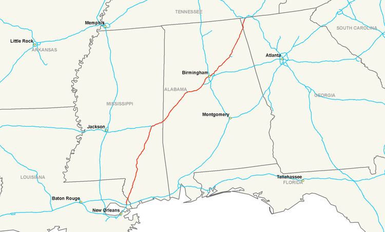 | ||
Interstate 59 (I-59) is a north–south Interstate Highway in the southern United States. Its southern terminus is near Slidell, Louisiana, a northeastern suburb of New Orleans, at its interchange with I-10 and I-12, and its northern terminus is at Wildwood, Georgia, at its interchange with I-24. The highway's major purpose is to connect Chattanooga, Tennessee, and points north, with New Orleans via Birmingham, Alabama. Along its entire route, I-59 is parallel to U.S. Route 11 (US 11). I-59 is a four-lane freeway along its entire route except for some portions north of Tuscaloosa, Alabama and in the Birmingham, Alabama, metropolitan area, where it is several lanes wider.
Contents
Map of I-59, United States
About a third of the entire route overlaps with Interstate 20 between Birmingham, Alabama and Meridian, Mississippi.
Louisiana
In the U.S. state of Louisiana, I-59 is shorter than it is in any other state: Alabama, Mississippi, and Georgia. From south-to-north, I-59 begins at its junction with I-10 and I-12 near Slidell. Then it bypasses Pearl River before crossing the West Pearl River and then the East Pearl River. At the East Pearl River, I-59 leaves St. Tammany Parish and it enters Pearl River County, Mississippi.
Mississippi
In Mississippi, I-59 continues to run parallel with US 11, traversing mainly rural areas, but going through or bypassing the towns of Picayune, Poplarville, Hattiesburg, Ellisville, Moselle, Laurel, and Meridian.
For its length in Mississippi, I-59 either travels concurrent with, or runs close to, US 11. Between the towns of Pearl River and Picayune, US 11 travels concurrent with I-59. The highway also has concurrencies with US 98 in Hattiesburg; US 84 and Mississippi Highway 15 (MS 15) in Laurel, and US 80, US 11, and MS 19 in the Meridian area.
A notoriously sharp S-curve, at milepost 96 in Laurel, was the subject of a large reconstruction project. Those sharp curves were the legacy of an overpass over the Southern Railway on a town bypass with design dating from before the Interstate Highways, and they featured a 40 mph (64 km/h) speed limit, one of the lowest anywhere on the Interstate Highway System. This work was completed in 2009.
Just west of Meridian, I-20 joins I-59 and these two highways continue together for 145 miles (233 km), across the border with Alabama to and through Birmingham. The exit numbers are given as those of I-59.
At 4:00 p.m. on August 27, 2005, for the first time in its history, the southbound lanes of I-59 were temporarily redirected northward to accommodate evacuation for Hurricane Katrina. This was a previously agreed to joint plan by the states of Mississippi and Louisiana called contraflow lane reversal. The program began at the Louisiana–Mississippi state line and continued 21 miles (34 km) north to Poplarville.
Alabama
I-59 and I-20 travel together for about 40 percent of their route through Alabama, passing northeast through Tuscaloosa before finally parting ways in eastern Birmingham.
In Birmingham, many wrecks and accidents occur near the cross-over interchange of I-20/I-59 and I-65(commonly called "Malfunction Junction"). On two occasions, 18-wheelers crashed and burned fiercely enough to melt the support beams of overpasses. Beginning in eastern Birmingham, I-59 continues on its own northeast, passing by Gadsden and Fort Payne in the foothills of the Appalachian Mountains, before entering Georgia.
I-59 from Gadsden at mile marker 182 to Stephen's Gap at mile marker 193 had degraded over the decades since it was opened into a rough concrete highway. Between 2010 and 2014, a construction project called "Project 59" took place between Gadsden and Fort Payne. This project consisted of reconstructing the Interstate Highway with unbonded concrete (without any space cracks) as well as modifications to the width and vertical clearance of the bridges and overpasses in the segment.
Georgia
I-59 has a short trek through Georgia, with only three exits before ending at I-24 several miles west of Chattanooga, Tennessee, in Wildwood, Georgia. Within Georgia it carries unsigned designated as State Route 406 (SR 406) for internal Georgia Department of Transportation (GDOT) purposes.