
Length 589 km | ||
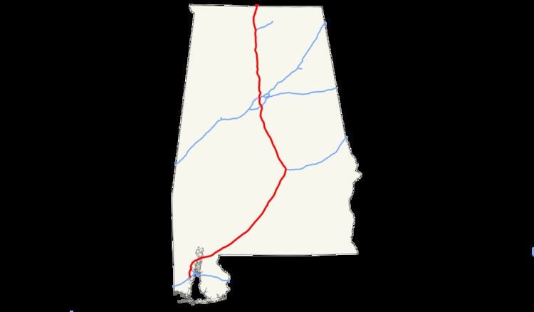 | ||
Interstate 65 (I-65) meanders across 366 miles (589 km) of the Alabama countryside linking six of the state's ten largest cities. The highway links together many important roadways that make commerce inside and outside of the state's boundaries possible. It starts at Interstate 10 near Mobile. The route passes through the major cities of Montgomery, Birmingham, and Decatur before entering Tennessee in the north near the town of Ardmore.
Contents
Map of I-65, United States
The entire Alabama portion of I-65 is dedicated as Heroes Highway, in honor of the CIA officer Johnny "Mike" Spann and all of the people who died during the September 11 attacks.
Route description
I-65 starts in Mobile at an interchange with Interstate 10, not far from the Gulf of Mexico. From there it runs northeast, intersecting with I-165 in Prichard, Alabama and crossing the Mobile River delta at the General W.K. Wilson Jr. Bridge. En route to Montgomery, it passes county seats Evergreen (Conecuh County) and Greenville (Butler County). In the case of an hurricane evacuation on Alabama's coast, I-65 can be converted to an evacuation route where all lanes flow in the northbound direction from Mobile to Montgomery. This process is known as contra-flow.
At Montgomery, it intersects the southern terminus of I-85 and crosses the Alabama River north of the city. The Hyundai Corporation's automotive plant in Montgomery is located just off I-65. It can be accessed using the Pintlala-Hope Hull exit (number 164).
At Chilton County, I-65 enters the Birmingham, Alabama, metropolitan area. Approximately halfway between Montgomery and Birmingham, it passes Clanton (Chilton County seat), where the water tower, visible from the road, is shaped and painted to resemble a huge peach. Between mile markers 212 and 219, I-65 was designated "War on Terror Memorial Highway" in 2014.
From mile marker 242 to 290 I-65 carries at least 6 lanes of traffic. I-65 intersects I-459 in Hoover, then passes through the cities of Vestavia Hills and Homewood, which often generate heavy traffic. As the interstate passes by downtown Birmingham, south-bound travelers have a view of the Vulcan statue atop Red Mountain. At the north edge of downtown, I-65 intersects I-20/I-59 with a cross-over interchange, often called "Malfunction Junction".
North of Birmingham at mile 266, interchange ramps provide access to parallel US-31. It is here that I-65 meets the eastern terminus of I-22, which heads northwest to Memphis, Tennessee, filling in a gap in the Interstate system. The interstate then continues 98 miles (158 km) in the general direction of Huntsville, passing the city of Cullman on the way. After entering the Decatur Metropolitan Area, in southern Morgan County, the interstate passes Decatur. The highway connects the Decatur and Huntsville Metropolitan Areas as it crosses Wheeler Lake (Tennessee River) on a 2.6-mile (4.2 km) bridge. The interstate emerges again into the fringes of Decatur, in an open area of seemingly "endless" cotton fields where it intersects, inside Decatur, with Alabama 20, US-72 Alternate, and the spur-route, I-565 to Huntsville.
Between Walkers Chapel Road in Fultondale and the Tennessee River in Decatur (Limestone County), I-65 has been designated the "Ronald Reagan Memorial Highway". The sign designating the north end of this portion of road cites Reagan's speech in Decatur on July 4, 1984. The interstate then continues, passing Athens, and merges with US-31. The 2 routes travel concurrently approximately 12 miles to the Tennessee state line.
In the Birmingham/Hoover vicinity, a plan to widen the interstate from North Birmingham to Alabaster has been proposed. The project is to widen the interstate by adding a HOV lane and keeping the original 3 lanes making it four lanes in each direction. This is planned to stretch to the Pelham area. From there on the interstate will widen from 2 lanes each way to 3 lanes each way into the Helena/Alabaster area.
Near the northern border of Alabama with Tennessee on southbound I-65 is located the Alabama Welcome Center and rest area. The unique feature of this rest area compared to others is the existence of a large Saturn IB rocket erected on the site as a memorial to Alabama's—and in particular, Huntsville's—contribution to NASA's space exploration.
History
In 1997, at Georgiana (Exit 114), honoring legendary country musician and Alabama native Hank Williams, the interstate was designated as Hank Williams' Memorial "Lost Highway", after one of his songs. This designation continues northward until mile 179 north of Montgomery. From the state's capital, I-65 doglegs northwards, bypassing Prattville and Clanton before going through Metropolitan Birmingham, Alabama. From exit 242 to 290, this highway carries at least six lanes of traffic. A portion of the interstate running through Birmingham, has been nicknamed "Malfunction Junction" for its numerous wrecks. These accidents include two separate occasions of the support beams melting after crashes by 18-wheelers, and the numerous collisions that happen every year, result from the junction with I-20 and I-59.
In 2004, following the death of President Ronald Reagan, a lengthy segment of I-65 from Jefferson County to Limestone County was designated the Ronald Reagan Memorial Highway. The sign designating the north end of the segment includes a statement from Reagan's speech at Point Mallard Aquatic Center in nearby Decatur on July 4, 1984.
Future
Just a few miles north of I-22 will be the new interchange (exit 274), which will be the Corridor X-1 and has been designated as I-422. This loop route will connect I-65 with I-59 northeast of Birmingham and I-20/I-59 southwest of Birmingham, and this will serve as an Interstate Highway bypass of Birmingham, augmenting the existing I-459, which already provides the southern loop of Birmingham. Construction of this interchange is still several years away, but right-of-way is in the process of being acquired to build I-422.