
Length 509.1 km | ||
 | ||
States: IllinoisKentuckyTennesseeGeorgia | ||
Interstate 24 east as we roll towards chattanooga tennessee and lookout mountain
Interstate 24 (I-24) is an Interstate Highway in the Midwestern and Southeastern United States. It runs diagonally from I-57, 10 miles (16 km) south of Marion, Illinois, to Chattanooga, Tennessee, at I-75. As an even-numbered Interstate, it is signed as an east–west route, though the route follows a more southeast–northwest routing. Because the routing of I-24 is diagonal, the numbering is a bit unusual as it does not completely follow the Interstate Highway System numbering conventions.
Contents
- Interstate 24 east as we roll towards chattanooga tennessee and lookout mountain
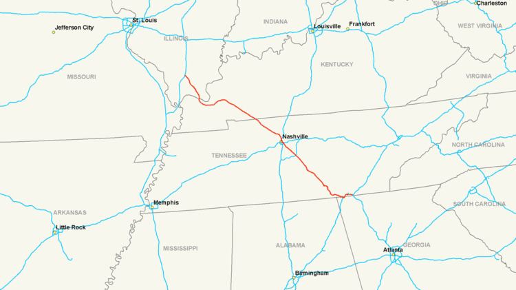
- Map of I 24 United States
- Illinois
- Kentucky
- Tennessee
- Georgia
- History
- Auxiliary route
- Paducah business loop
- References
Map of I-24, United States
I-24 makes up the majority of a high-traffic corridor between St. Louis, Missouri, and Atlanta. This corridor utilizes I-64 and I-57 northwest of I-24, and I-75 southeast of I-24.
Illinois
I-24 begins at exit 44A on I-57 in southern Williamson County, near the community of Pulleys Mill. The highway heads southeast into rural Johnson County, bypassing Goreville to the east. It reaches an exit at Tunnel Hill Road, which serves Goreville and Tunnel Hill. The highway continues south to its next exit at U.S. Route 45 (US 45) north of Vienna. It reaches its next exit at Illinois Route 146 (IL 146) in eastern Vienna. I-24 heads southeast from Vienna into Massac County. Its first exit in Massac County is at Big Bay Road, which serves the communities of Big Bay and New Columbia. I-24 continues southward, bypassing the community of Round Knob before entering Metropolis. The highway meets US 45 again in Metropolis and passes west of Fort Massac State Park. It leaves Metropolis to the south by crossing the Interstate 24 Bridge over the Ohio River, continuing into Kentucky.
Kentucky
I-24 crosses into Kentucky on a bridge over the Ohio River, passing to the west of the city of Paducah and intersecting US 60, US 45, and US 62. The freeway then passes near the communities of Woodlawn-Oakdale and Reidland, and connects with US 68. East of this point, I-24 runs concurrently with I-69, intersecting US 62 and crossing the Tennessee River and the Cumberland River. The roadway travels along the north shore of the Cumberland River as I-69 splits off to the east just north of Mineral Mound State Park. I-24 continues east, away from the river, through farmland for several miles, passing well south of Hopkinsville. Near the Tennessee border, I-24 passes north of Fort Campbell before crossing into Tennessee.
I-69 runs concurrently with I-24 for 17 miles (27 km) from the Purchase Parkway in Calvert City to the Western Kentucky Parkway near Eddyville.
Tennessee
One of the more hazardous stretches of Interstate highway in the United States is located approximately 40 miles (64 km) west of Chattanooga on I-24 in Monteagle, where the highway crosses the Cumberland Plateau. Compared to grades elsewhere, Monteagle's 4–6% grade does not come close to the steepest (I-40 between Nashville and Knoxville features 5% grades in each direction as well as a 5% grade north of Nashville on I-24, near Joelton), but the slope is protracted over a distance of several miles. While all motorists need to exercise caution, truckers are particularly vexed by Monteagle, and many have died going through this area. As runaway trucks had been a regular and deadly occurrence, in part of the failure or inability of truckers to slow down to the 35 miles per hour (55 km/h) truck speed limit once on the slope, the eastbound lanes were rebuilt in the late 1980s. This work reduced the grade, widened the road, added a required stopping area with traffic lights for trucks prior to descending the mountain, and added two runaway truck ramps where a truck whose brakes have failed due to overheating can exit into a long pit full of loose gravel to safely stop. Owing to geography, these two ramps are on the left side of the grade. This stretch of highway inspired Johnny Cash to write a song about Monteagle Mountain. It is also mentioned in "The Legend", the introductory song for Smokey and the Bandit, which touts the protagonist's driving skill in having reportedly navigated his truck down the Monteagle Grade during a heavy rainstorm, despite an airbrake failure.
The Monteagle grade also has one of the three widest medians of any Interstate highway, with the others being I-8 through the In-Ko-Pah grade in California and I-84 through the Cabbage Hill grade east of Pendleton, Oregon. There is more than a mile between the eastbound and westbound lanes at one point. The eastbound lanes descend the mountain on one side of a ridge, while the westbound lanes ascend the other. Also of interest on Monteagle Mountain is the steep grade on I-24 north of Monteagle. This steep grade occurs for westbound traffic and features a sharp 45 mph (70 km/h) curve to the right while descending steeply at the same time. This downhill curve also features off-ramp approach style lane dividers, in order to slow both motorists and truckers. Also in Chattanooga is the "Ridge Cut", a one-quarter-mile (400 m) section of Missionary Ridge, between the 4th Avenue exit and the Germantown/Belvoir exit. Accidents and severe congestion are common here. I-124 is an occasional (currently unsigned) designation of a portion of the US 27 freeway, which runs as a spur into downtown Chattanooga and beyond.
Georgia
In the state of Georgia, I-24 runs for four miles (6.4 km), running along the southern flank of Raccoon Mountain and intersecting with I-59 before turning back north to the Tennessee River and around the northern flank of Lookout Mountain. The exits remain numbered according to Tennessee's mileposts. However, the mileposts are Georgia's mileposts. This segment is also officially State Route 409.
History
I-24 was part of the original Interstate Highway System plan enacted in 1956. The section of I-24 in Illinois was authorized for engineering by 1966 and authorized for construction by 1968. The highway opened to traffic by 1977.
On May 18, 2010, it was announced that a sinkhole was found in the eastbound lanes of I-24 in Grundy County, Tennessee, near the exit of Tennessee State Route 50. Tennessee Department of Transportation officials stated that hole was growing with traffic diverted onto the westbound lanes. However, emergency repairs commenced and was reopened several days later.
Auxiliary route
Paducah business loop
Interstate 24 Business (BL 24) is a 11-mile (18 km) business loop of I-24 that runs through downtown Paducah, Kentucky that begins at I-24 and US 60 at exit 4 and ends at I-24 and Kentucky Route 1954 (KY 1954) at exit 11. The route follows US 60, US 60 Bus., and KY 1954.
The entire route is in McCracken County.