
Length 1900 mi (3058 km) Lowest point Cap Gaspé Phone +1 418-560-4642 | Province Québec | |
 | ||
Address 968 Avenue du Phare Ouest c.p. 132, Matane, QC G4W 1V7, Canada Hours Closed now Monday9AM–4PMTuesday9AM–4PMWednesday9AM–4PMThursday9AM–4PMFriday9AM–12PMSaturdayClosedSundayClosed Similar Mount Katahdin, Mont Jacques‑Cartier, Jardins de Doris (Les), Parc des îles, Musee La Maison Horace B | ||
Is this a trail international appalachian trail 2015
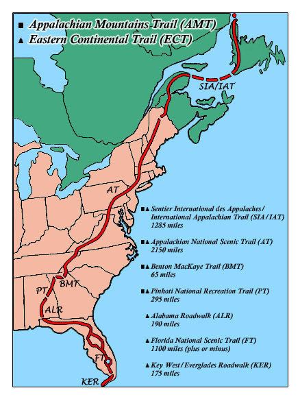
The International Appalachian Trail (IAT; French: Sentier international des Appalaches, SIA) is a hiking trail which runs from the northern terminus of the Appalachian Trail at Mount Katahdin, Maine, through New Brunswick, to the Gaspé Peninsula of Quebec, after which it takes a ferry ride to Newfoundland, and then continues to the northern-easternmost point of the Appalachian Mountains at Belle Isle, Newfoundland and Labrador.
Contents
- Is this a trail international appalachian trail 2015
- The international appalachian trail of newfoundland labrador
- History
- Route
- Extension to Europe and North Africa
- Scenery
- References
Further sections have been designated within Great Britain and Ireland, and there are proposals to extend it further within Europe and North Africa.
The international appalachian trail of newfoundland labrador
History
The IAT was proposed in 1994 by Richard Anderson, a Maine fisheries biologist, with plans to traverse the portions of the Appalachian Mountains in Maine, New Brunswick, and Quebec that the Appalachian Trail did not cover. Following route selection, construction of the trail took place through the late 1990s.
The first person to thruhike the IAT, as it then existed, was John Brinda from Washington State, in 1997. He did this as part of his thruhike of the Eastern Continental Trail starting in Key West, Florida. He was the first person to thruhike the entire Eastern Continental Trail.
The Newfoundland and Labrador extension to the IAT was proposed in 2003 and is still under construction. When completed, it will add an additional 1,200 km of trail. The official opening of the first trail section of the IAT Newfoundland was September 23, 2006.
Route
The IAT extends northeast from the northern terminus of the Appalachian Trail at Katahdin, Maine to Mars Hill, Maine, before following the U.S.-Canada border north to Fort Fairfield, Maine, where it crosses the border into Perth-Andover, New Brunswick. It continues up the Tobique River valley to Mount Carleton before crossing the Miramichi Highlands to the Restigouche River valley in Quebec and along the Chic-Choc Mountains of the Gaspé Peninsula, ending at the peninsula's easternmost point, Cap Gaspé in Forillon National Park.
From Cap Gaspé, the IAT skips to Prince Edward Island, Nova Scotia, and over the Gulf of St. Lawrence to Newfoundland, where the trail picks up again at Channel-Port aux Basques and follows the west coast of the island up the Great Northern Peninsula before terminating at the island's northernmost tip, Cape Bauld. From there the IAT skips over the Strait of Belle Isle to the northern terminus of the Appalachian Mountain chain at Belle Isle.
Extension to Europe and North Africa
Geological evidence shows that the Appalachian Mountains, certain mountains of Western Europe, and the Anti-Atlas range in North Africa are parts of the ancient Central Pangean Mountains, made when minor supercontinents collided to form the supercontinent Pangaea more than 250 million years ago. With the break-up of Pangaea, sections of the former range remained with the continents as they drifted to their present locations. Inspired by this evidence, efforts are being made to extend the IAT into Western Europe and North Africa.
In April 2010 Greenland became the seventh chapter of the International Appalachian Trail. The route is on the Nuussuaq Peninsula near Uummannaq Fjord.
Greenland was followed by Scotland in June, when the West Highland Way became the first IAT trail in Europe.
In October 2010 the IAT expanded further into Europe when nine new chapters joined the IAT at a meeting in Aviemore, Scotland. The meeting was attended by the IAT President and representatives from Coast Alive, the British Geological Survey, Visit Scotland, and Fáilte Ireland. The new chapters include Norway, Sweden, Denmark, the Netherlands, England, Ireland, Wales, the Faroe Islands, and Iceland.
Spain also joined the IAT in 2010.
Scenery
Scenic highlights along the route include:
Canada
Europe
Parks include:
Canada
Europe