
Elevation 1,606 m First ascent 1804 Mountain range Appalachian Mountains | Designated 1967 Prominence 1,307 m Easiest route Hiking First ascender Charles Turner, Jr. | |
 | ||
Listing North America isolated peaks 78thU.S. state high point 22ndNew England Fifty Finest 2ndNew England 4000-footers Similar Springer Mountain, Mount Washington, Cadillac Mountain, Clingmans Dome, Hamlin Peak | ||
Mount katahdin knife edge gopro
Mount Katahdin (pronounced /kəˈtɑːdən/, "kə-TAH-dən") is the highest mountain in the U.S. state of Maine at 5,267 feet (1,605 m). Named Katahdin by the Penobscot Indians, which means "The Greatest Mountain", Katahdin is the centerpiece of Baxter State Park. It is a steep, tall mountain formed from a granite intrusion weathered to the surface. The flora and fauna on the mountain are typical of those found in northern New England.
Contents
- Mount katahdin knife edge gopro
- Map of Mt Katahdin Northeast Piscataquis ME 04462 USA
- Appalachian trail mount katahdin 129
- GeographyEdit
- Natural historyEdit
- Human historyEdit
- Recreation opportunitiesEdit
- Knife EdgeEdit
- Mt Katahdin TrailsEdit
- AbolEdit
- HuntEdit
- Helon TaylorEdit
- DudleyEdit
- CathedralEdit
- SaddleEdit
- Hamlin RidgeEdit
- Chimney PondEdit
- In popular cultureEdit
- References
Map of Mt Katahdin, Northeast Piscataquis, ME 04462, USA
Katahdin was known to the Native Americans in the region, and was known to Europeans at least since 1689. It has inspired hikes, climbs, journal narratives, paintings, and a piano sonata. The area around the peak was protected by Governor Percival Baxter starting in the 1930s. Katahdin is the northern terminus of the Appalachian Trail, and is located near a stretch known as the Hundred-Mile Wilderness.
The mountain is commonly called just "Katahdin", including by Baxter State Park in official publications. The official name is "Mount Katahdin" as decided by the US Board on Geographic Names in 1893.
Appalachian trail mount katahdin 129
GeographyEdit
Katahdin is in Baxter State Park, which is in east central Piscataquis County, about 25 mi (40 km) northwest of Millinocket. It is on the drainage divide between the East and West branches of the Penobscot River and is the northern terminus of the Appalachian Trail.
The third highest mountain in Maine, Sugarloaf Mountain at 1,295 m (4,250 ft), is over one hundred miles to the southwest. There is low lake country to the south and west of Katahdin, and lowlands extending east to the Atlantic and north to the Saint Lawrence River in Canada.
It is commonly thought that Katahdin is the first place in the United States mainland to receive sunlight in the morning, but this is incorrect. Other mountains, lower in elevation but farther to the east or southeast, depending on the season, see the first sunrise of the day.
Natural historyEdit
Katahdin is part of a laccolith that formed in the Acadian orogeny, when an island arc collided with eastern North America approximately 400 million years ago. On the sides of Katahdin are four glacial cirques carved into the granite by alpine glaciers and in these cirques behind moraines and eskers are several ponds.
In Baxter State Park, many outcrops of sedimentary rocks have striations, whereas Katahdin Granite and Traveler Rhyolite lava have weathered surfaces on which striations are commonly not preserved. Bedrock surfaces of igneous rocks which have been buried by glacial sediments and only recently exposed have well preserved striations, as in the vicinity of Ripogenus Dam. Several outcrops of sedimentary rocks along the Patten Road show striations, especially on the north side of the road at Hurricane Deck. A few outcrops near the Pattern Road just north of Horse Mountain are striated, as are several outcrops of sedimentary rocks along the road from Trout Brook Farm northward to Second Lake Matagamon.
Fauna include black bear, deer and moose as well as black flies and mosquitos in the spring. A subspecies of arctic butterfly, known as the Katahdin arctic (Oeneis polixenes katahdin) is specific to the area, and is currently listed as endangered. Among the birds are Bicknell's thrush and various songbirds and raptors. A study of the animal communities was published by Irving H. Blake in 1926. The flora includes pine, spruce, fir, hemlock, beech, maple, birch, aspen, and Diapensia lapponica.
Human historyEdit
Katahdin is referred to 60 years after Field’s climb of Agiokochuk (Mount Washington) in the writings of John Gyles, a teenage colonist who was captured near Portland, Maine in 1689 by the Abenaki. While in the company of Abenaki hunting parties, he traveled up and down several Maine rivers including both branches of the Penobscot, passing close to “Teddon”. He remarked that it was higher than the White Hills above the Saco River.
Among some Native Americans, Katahdin was believed to be the home of the storm god Pamola, and thus an area to be avoided.
The first recorded climb of "Catahrdin" was by Massachusetts surveyors Zackery Adley and Charles Turner, Jr. in August 1804. In the 1840s Henry David Thoreau climbed Katahdin, which he spelled "Ktaadn"; his ascent is recorded in a well-known chapter of The Maine Woods. A few years later Theodore Winthrop wrote about his visit in Life in the Open Air. Painters Frederic Edwin Church and Marsden Hartley are well-known artists who created landscapes of Katahdin. On 30 November 2011, Christie's auctioned Church's 1860 painting Twilight (Katahdin) for $3.1 million.
In the 1930s Governor Percival Baxter began to acquire land and finally deeded more than 200,000 acres (809 km2) to the State of Maine for a park, named Baxter State Park after him. The summit was officially recognized by the US Board on Geographic Names as "Baxter Peak" in 1931.
Recreation opportunitiesEdit
As the northern terminus of the Appalachian Trail and southern terminus of the International Appalachian Trail, Katahdin is a popular hiking and backpacking destination and the centerpiece of Baxter State Park. Baxter State Park is open year round, though strictly regulated in winter. The overnight camping season is from May 15 to October 15 each year. Capacity limits have been placed on day use parking at the trailheads to minimize the overuse of trails.
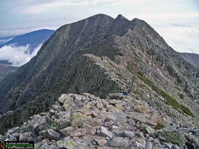
Knife EdgeEdit
The most famous hike to the summit goes along Knife Edge, which traverses the ridge between Pamola Peak and Baxter Peak. The mountain has claimed 23 lives since 1963, mostly from exposure in bad weather and falls from the Knife Edge. For about 3/10 of a mile the trail is 3 feet wide, with a drop off on either side. The Knife Edge is closed during periods of high wind.
Mt. Katahdin TrailsEdit
Mt. Katahdin has several trails leading up to either Pamola or Baxter Peak. There are two trails, Hunt and Abol, accessible from the south side of the mountain each having its own separate parking lot. These trails start right up the mountain, but each trail on the mountain ends up taking eight to ten hours round-trip depending on ability. The rest of the trails go up the north side or west side of the mountain. These are accessed from the Chimney Pond Trail. For these trails, hikers must park at the Roaring Brook Campground and hike in. All trails are maintained by the Baxter State Park Authority, which runs the State Park. All of the trails on the mountain are classified as very strenuous, the highest classification the Park Authority gives, except for Saddle (strenuous), Hamlin Ridge trail (moderate), and Chimney Pond (moderate).
AbolEdit
Abol is one of the trails on the south side of the mountain. At 3.8-miles, it is the fastest way to Baxter Peak. Steep and composed of small loose rocks, it is a secondary choice for hikers taking the Appalachian Trail. At the top is the half mile long Abol Slide, which many hikers compare to hiking up a steep beach, taking two steps forward and three steps back. The old Abol Trail was closed to hiking for an extended period due to loose rock that shifted during the winter of 2013–14. A re-route was opened on Friday, July 1st, 2016.
HuntEdit
The Hunt trail is the northernmost section of the Appalachian Trail, and the trail most accessed from the backside of the mountain. Ending at the summit of Baxter Peak, the 5.2-mile long trail is the longest up the mountain In both length and time. The beginning mile and a half is not that steep. Hikers pass over mountain streams and numerous waterfalls. It takes a while for the trail to become steep. Once the tree line is reached, however, Hunt is known for its boulders. These giant rocks are very difficult to traverse. Hikers must use metal handlebars secured in to rock to progress through the latter part of the trail up to the Gateway. This section of the trail is considered a very difficult climb. From here, the trail traverses along relatively flat tablelands for roughly 1.5 miles to the summit.
Helon TaylorEdit
Helon Taylor is a trail on the east side of the mountain. This trail is 3.2 miles in length. Hikers still must park at Roaring Brook, but the trail splits off from the Chimney Pond Trail. The trail is named after a longtime overseer of the park. The trail climbs up to Pamola Peak where hikers must climb Knife’s Edge to get to Baxter Peak.
DudleyEdit
Dudley is a trail on the north side of the mountain. This trail is 1.3 miles, and goes to Pamola Peak. It is known for its boulders that hikers must climb between instead of over. The top section of the trail is all loose rock. It is the location of a notable landmark called Index Rock. Many hikers stop here to get stunning photos. The rock is a few hundred feet in length and juts out the side of the mountain. From the other side of the mountain, this rock is the only one distinguishable.
CathedralEdit
Cathedral trail is a trail on the front of the mountain that goes to Baxter Peak. It is 1.7 miles in length. It is one of the more steep trails. It is known for its three giant granite structures named Cathedrals 1–3. It is a style of hiking similar to rock climbing called scrambling because one must traverse huge rocks the entirety of the trail. It is not recommended that hikers climb down this trail because of its steep nature.
SaddleEdit
Saddle trail is on the front of the mountain and goes to Baxter Peak. It is 2.2 miles in length. It is one of the easier trails on the mountain. It is accessed from the Chimney Pond Trail and Roaring Brook Campground. It has loose rocks, but does not have the big rocks to traverse. It is recommended for beginners, and it is often the safety net for hikers who encounter bad weather.
Knife EdgeEdit
The Knife Edge is the trail that connects Pamola and Baxter Peak. It is 1.1 miles in length. It is the most notable feature of Katahdin. The path stretches roughly a mile and is all sharp granite rocks, surrounded on both sides by steep cliffs. In sections it is only three feet wide. It is a dangerous part of the mountain and accounts for the most deaths. The Baxter State Park Authority closes the trail in any wind or rain and only recommend the trail be hiked in the best of conditions.
Hamlin RidgeEdit
The Hamlin Ridge Trail is accessed from the plateau on the top of the mountain accessed by Cathedral and Saddle trails. It is 1.5 miles long. The trail goes to Hamlin Peak, a smaller and less popular peak. It is gradual and short.
Chimney PondEdit
The Chimney Pond trail is the trail used to access the front of the mountain. It is 3.3 miles in length. It begins at Roaring Brook Campground and ends at Chimney Pond in the base of Katahdin. It is a three-mile trail that is not as difficult as the mountain trails. It passes by a large number of lakes and streams. Hikers get occasional views of the mountain along the way.