
Established 1952 | Area 629 km² Phone +44 1646 624800 | |
 | ||
Similar Coastal Cottages of Pembrok, Pembrok County Council, Coast and Country Cottages, Bluestone National Park Res, Quality Cottages Profiles | ||
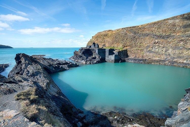
Visit pembrokeshire summer from the coastal path
Pembrokeshire Coast National Park (Welsh: Parc Cenedlaethol Arfordir Penfro) is a national park along the Pembrokeshire coast in west Wales.
Contents
- Visit pembrokeshire summer from the coastal path
- Wales pembrokeshire coast national park
- Landscape
- Pembrokeshire Coast Path
- Administration
- Beaches
- Electric vehicles
- References
It was established as a National Park in 1952, and is the only one in the United Kingdom to have been designated primarily because of its spectacular coastline. It is one of three National Parks in Wales, the others being the Brecon Beacons (Bannau Brycheiniog) and Snowdonia (Eryri).
Wales pembrokeshire coast national park
Landscape
The National Park has a varied landscape of rugged cliffs, sandy beaches, wooded estuaries and wild inland hills, covering a total area of 629 km2 (243 sq mi). It falls into four distinct sections. Running clockwise around the coast, these are the south Pembrokeshire coast, including Caldey Island; the Daugleddau estuary; the St Bride's Bay coast, including the coastal islands; and the Preseli Hills. However, not all of the park is coastal, and there are even forests and marshes on the edges of the park.
The geology of the area is of particular interest with many good exposures both inland and along the coast, exhibiting a variety of rock types and structural features such as natural arches, stacks, rock folding and sea caves. A stack of note is Stack Rocks (Elegug Stacks), two large detached pillars of limestone. In the north, the rocks of Carn Llidi, Pen Beri and Garn Fawr, together with the extensive moorland on Mynydd Carningli and Mynydd Preseli, give an exposed and mountainous feel to the landscape, cut through by the wooded valleys of the Gwaun and Nevern. In the west, the National Park is dominated by the broad sweep of St Bride's Bay, bounded at its northern end by Ramsey Island, near St David's peninsula, and at its southern end by Skomer. The southern coast is another contrast, with the limestone plateau and cliffs of the Castlemartin peninsula, the steep-sided wooded valleys inland from Amroth; the Bosherston lakes - now, like much of the coastal strip, in the care of the National Trust - and the tourist resorts of Tenby and Saundersfoot. Between the western and southern areas of the National Park lies the Milford Haven waterway, where the tranquil Daugleddau estuary feeds into one of the finest natural deep water harbours in the world.
The National Park includes many sites (such as Pentre Ifan) and areas which are of national or international conservation significance in their own right, including 7 Special Areas of Conservation, a Marine Nature Reserve, 6 national nature reserves and 75 Sites of Special Scientific Interest.
In 2011 National Geographic magazine voted Pembrokeshire the second best coastal destination in the world.
In January 2016 the Authority launched the "Changing Coasts" project to document the way the coastline has changed as a result of recent winter storms; the project invites visitors to submit photographs taken (at any time of day) from fixed points; a pilot study will be carried out at Abereiddy.
Pembrokeshire Coast Path
The Pembrokeshire Coast Path is a designated National Trail. It was established in 1970, and is 186 miles (299 km) long, mostly at cliff-top level, with a total of 35,000 feet (11,000 m) of ascent and descent.
The southern end of the path is at Amroth. The northern end is often regarded as being at Poppit Sands, near St. Dogmaels, where the official plaque was originally sited but the path now continues to St. Dogmaels, where a new marker was unveiled in July 2009. Here the path links with the Ceredigion Coast Path, which continues northwards.
The Pembrokeshire Coast Path forms part of the Wales Coast Path, an 870-mile (1,400 km) long-distance walking route around the whole coast of Wales from Chepstow to Queensferry, which was officially opened in 2012.
Administration
The Park is managed by Pembrokeshire Coast National Park Authority, which has around 130 staff and a committee of 18 members. The Authority's purposes are to conserve the National Park, encourage the public to enjoy and understand it, and to foster the social and economic well-being of the communities within its boundaries. Its offices are in Pembroke Dock.
The Authority also manages the entire length of the Pembrokeshire Coast Path, a 186-mile (299 km) national trail which lies almost entirely within the Pembrokeshire Coast National Park.
Beaches
Over the years Pembrokeshire's beaches, all of which lie in the National Park, have been awarded many International Blue Flag Awards (10 in 2014), 47 Green Coast Awards (15 in 2011) and 106 Seaside Awards (31 in 2011). In 2011 it also had 39 beaches recommended by the Marine Conservation Society.
Beaches in the park include:
Electric vehicles
Electric bicycles were introduced in 2005 by the National park authority for use by its employees.