
Length: 90.4 mi (145.5 km) Route: Route X | Formed: 2004 | |
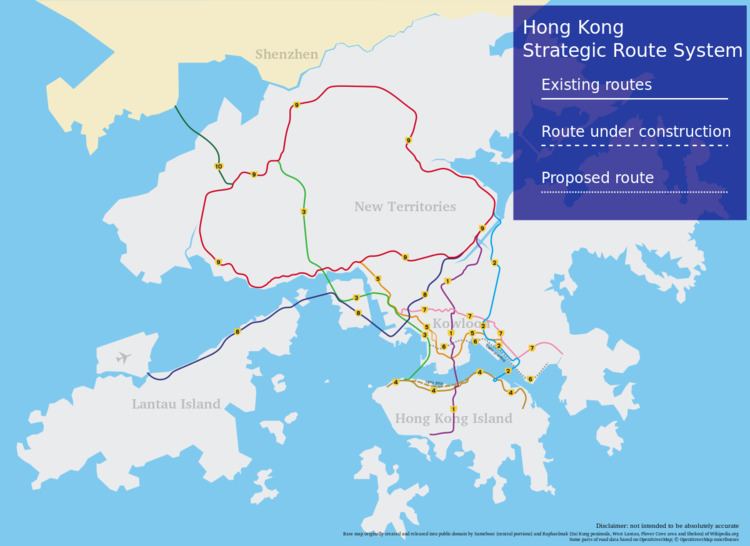 | ||
The Hong Kong Strategic Route and Exit Number System (Chinese: 香港主要幹線及出口編號系統) is a system adopted by the Transport Department of the Hong Kong Government to organise the major roads in the territory into Routes 1 to 10 for the convenience of drivers. When the system was first implemented in 2004, the government launched a major campaign to promote it to the public. One of the slogans was "Remember the Numbers; Make Driving Easier" (Chinese: 認路記號碼,唔使路路查).
Contents
- Features
- Route number system
- Exit number system
- First generation
- Second generation
- Third generation
- References
The system comprises nine major series of roads in Hong Kong, numbered Routes 1 to 5 and 7 to 10, which can be classified into three categories: the three north-south routes, the five east-west routes and the New Territories Circular Road. The route numbers are represented as black on yellow "road-shields" on overhead roadsigns.
The system also implemented exit numbering on the aforementioned routes. The exits of each route are numbered sequentially; some exit numbers are suffixed with a letter. Exit numbers are indicated by white in black rectangular boxes on overhead and roadside signs.
Features
There are no traffic lights on the expressways. Traffic interchange with other roads is entirely via slip roads, maximising vehicular flow and land space usage. There are some stack interchanges.
The Strategic Route System has traffic lights on only a few roads, such as Waterloo Road (Route 1) and Kwun Tong Road (Route 7).
The road surface is asphalt. The lanes are separated by white dashed lines, while unbroken white lines are used to mark the edges of the median and shoulder. The shoulder is reserved for stops due to breakdowns and emergencies, and motorists are prohibited by law from travelling on it. Lanes are numbered from right to left, with lane 1 being the closest to the median. Crash barriers, cat's eyes and rumble strips are also used to ensure road safety. Signs mark the start and end of an expressway at its entry and exit points respectively. These expressways do not have rest areas.
The speed limits for most vehicles on the Hong Kong highways are 110 km/h for North Lantau Expressway, 100 km/h for the New Territories roads and West Kowloon Highway, 80 km/h for the most expressways and 70 km/h, due to the older ones such as Island Eastern Corridor, East Kowloon Corridor, West Kowloon Corridor and Tsuen Wan Road. A speeding offence under 10 km/h over the speed limit is not usually enforced - many drivers in Hong Kong travel within this range. Cameras will shoot when it is above 15 km/h, with their fines imposed.
As stipulated by the Laws of Hong Kong Cap 374 s 40 (5) and (5A), medium goods vehicles, heavy goods vehicles and buses shall travel no faster than the speed limit of the road or 70 km/h, whichever is slower; while minibuses shall travel no faster than the speed limit of the road or 80 km/h, whichever is slower. Many vehicles of these types actually ignore this and simply follow the speed limit of the road on the Hong Kong highways, thereby commit speeding offence. However, this law is not usually enforced - cameras are not tuned to be triggered differently by these types of vehicle.
List of Asian Highway Networks:
Route number system
The three north-south routes include Route 1, Route 2, and Route 3. They connect Hong Kong Island, metro Kowloon and the New Territories via a series of flyovers and tunnels. They pass through the three tunnels crossing Victoria Harbour, and their sequence of numbering follows the order of opening dates of the three tunnels:
The five east-west routes — Route 4, Route 5, Route 7, Route 8 and Route 10 — are numbered from south to north. The pattern indicates that Route 6 will most likely be built between Routes 5 and 7. Route 4 runs along the north shore of Hong Kong Island, connecting the eastern and western ends of the island, whereas Routes 5 and 7 link southern New Territories with different parts of Kowloon. Route 8 provides direct access to Chek Lap Kok Airport, and was extended to Sha Tin in 2008. Route 10 provides access to the border crossing at Shekou, Shenzhen.
The circular route, Route 9, circumscribes the New Territories, with the exit at the Shing Mun Tunnels in Sha Tin as the starting point of exit-numbering. It links up the network of expressways and trunk roads in the New Territories into a large ring.
Exit number system
In parallel with route numbering, the junctions between routes and exits from routes are also labelled with exit numbers. On every route, exits are numbered from one end to the other with ascending consecutive integers with a mixture of alphabet-suffixed labels (1, 2, 2A, 2B, 3, 4... etc.).
First generation
The first generation of the route number system in Hong Kong was envisaged in the 1968 Hong Kong Long Term Road Study by Freeman, Fox, Wilbur Smith & Associates, in which trunk routes were given single-digit numbers, and distributors with double-digit ones. Also included in the road study was an unnumbered Western Harbour Crossing (WHC), which in the plan involved a bridge crossing the Victoria Harbour between Cherry Street in Mong Kok and Kennedy Town, by way of Stonecutters Island and Green Island.
Numbered routes included in the study were:
Second generation
The second generation of route numbers came into use in 1974. All distributors lost their numbers, retaining only trunk routes in the system. It was replaced in 2004 by the present-day third generation. At the new system's conception, some numbers were reserved for future road plans at that time. There were 11 routes in the system, of which nine (routes 1 to 9) were used as of 2004.
Third generation
The third generation of route numbers came into use in 2004, and is the system used at present.