
Local time Sunday 2:52 PM | ||
 | ||
Weather 21°C, Wind E at 3 km/h, 84% Humidity Restaurants Chaozhou Riri Fresh Beef Hot Pot Noodle | ||
Lok ma chau huang gang hong kong to china border at shenzhen november 2012
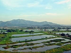
Lok Ma Chau or Lokmachau (Chinese: 落馬洲) is a village in Hong Kong's New Territories and also a major pedestrian (which is linked directly to the Hong Kong rapid transit network) and road border crossing point between Hong Kong and mainland China. It lies just south of the Sham Chun River (or Shenzhen River in Mandarin), which forms the border between Hong Kong and mainland China. Lok Ma Chau lies opposite Huanggang in Shenzhen, China.
Contents
- Lok ma chau huang gang hong kong to china border at shenzhen november 2012
- Map of Lok Ma Chau Hong Kong
- Facilities
- References
Map of Lok Ma Chau, Hong Kong
Lok Ma Chau lies within Hong Kong's Frontier Closed Area, a buffer zone established by the Hong Kong government to prevent illegal immigrants from mainland China, and access to the area is restricted to those holding Closed Area Permits. Those who are crossing the border to or from China do not need permits but must leave the area immediately after completing immigration procedures.
The proposed Lok Ma Chau Loop Innovation and Technology Park is located just east of the border post and will be expected to generate up to 1.2 million square metres of additional office space when completed.
To the southwest of Lok Ma Chau is the Mai Po Wetlands. The village belongs to the Cheung clan with ancestral roots that can be traced back to Shenzhen in China.