
Traditional Chinese 西營盤 Hanyu Pinyin Jyutping sai1 jing4 pun4 | Simplified Chinese 西营盘 IPA [sɐ́i jɪ̏ŋ pʰȕːn] Local time Tuesday 12:17 PM | |
 | ||
Weather 22°C, Wind E at 26 km/h, 65% Humidity Restaurants Metropolit, Fish School, Locofama, Flying Pig Bistro, High Street Grill Hotels BEST WESTERN PLUS Hot, Grand City Hotel, Island Pacific Hotel Ho, Courtyard by Marriott Hong Kong, Eco Tree Hotel | ||
Sai Ying Pun is an area in Western District, in the northwestern part of Hong Kong Island, in Hong Kong. It is administratively part of Central and Western District.
Contents
- Map of Sai Ying Pun Hong Kong
- hong kong walk tour central mid level sai ying pun sun yat sen memorial park
- Location
- Geology
- History
- Main streets
- Minor lanes
- Public facilities
- Education
- Historical Buildings
- Transportation
- References
Map of Sai Ying Pun, Hong Kong
In Chinese language (Cantonese dialect regarding the spoken version), Sai (西) means "west" and Ying Pun (營盤) means "camp", especially military camp. It was where the early British military stayed.
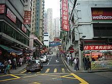
hong kong walk tour central mid level sai ying pun sun yat sen memorial park
Location
Sai Ying Pun is built on the steeply sloping lower slopes of Victoria Peak and also on the western reclamation. The areas of Shek Tong Tsui and Kennedy Town are located to the west, Sheung Wan and Tai Ping Shan are to the east, and the Mid-Levels is higher up the hill to the south. Victoria Harbour is to the north.
While the boundaries are not de jure drawn, they are nevertheless de facto defined by Whitty Street in the west and Tung Wah Hospital in the east. HKU Station exit B1 straddles the boundary between Shek Tong Tsui and Sai Ying Pun. Good Luck Mansion and The Kadoorie Biological Sciences Building are in Shek Tong Tsui, while Saint Anthony's Church, Pao Siu Loong Building, and the Main Building are in Sai Ying Pun. The eastern boundary is blurry. Lok Sin Tong Leung Kau Kui College is in Sai Ying Pun while Tung Wah Hospital is in Sheung Wan. The section of Queens Road West from Medal Court to Hollywood Road marks part of the boundary. Elsewhere, the location of the border is unknown. In a map, Sai Ying Pun can be distinguished from Sheung Wan because it is left of the street grid of the Tai Ping Shan neighborhood.
Geology
Sai Ying Pun is built on top of Hong Kong granite. The granite was formed in the Upper Jurassic Period and is from the last phase of intrusions in the Hong Kong area. The granite is found over most of the north and centre of Hong Kong Island, and also Kowloon. The flat parts of Sai Ying Pun near the harbour are reclaimed land, built from landfill.
History
Queen's Road was the first road built in the area. It meandered around the camp structures and extended along the north coast of Hong Kong Island.
Sai Ying Pun was settled as Chinese immigrants moved into Hong Kong and built to the west of Tai Ping Shan. Europeans were assigned areas above High Street where Chinese were excluded from living.
In the early 1880s sewerage was installed into the area, with the main flow coming down Centre Street. Streets were macadamised or concreted at this time also.
Around 1882 Battery Road was renamed Bonham Road.
From 1884 to 1887 many brothels were declared by the Government to be unlicensed and closed down. These were mainly in First, Second and Third Street, but also in Sheung Fung Lane, Ui on Lane and Centre Street.
In 1894 an epidemic of bubonic plague struck and afflicted Sai Ying Pun residents. It was not as bad initially as in neighbouring Tai Ping Shan, which was resumed, abandoned and demolished to improve hygiene. However Sheung Fung Lane residents were almost wiped out. Government Reports called this area the number IX health district and went into great detail about the buildings where the disease occurred. In 1896 there were 115 cases, in 1898, 153 cases, in 1899, 263 cases, in 1900 98 cases, in 1904 there were 149 cases with 144 dying, and 55 cases in 1905. The great majority of infections in this district resulted in death.
In 1902, number 10 and 12 Second Street partially collapsed killing four people and injuring six. An additional storey had been added to number 10 at the beginning of 1901. It fell on number 12 and caused it to collapse as well. The extension had been designed by architects Denison and Ram. Also in 1902 a cookhouse at 56 First Street collapsed, one person was killed.
In 1899, there were 1017 houses and a population estimate of 24800. Most houses in Des Voeux Road and First Street were three stories, and in Second and Third Street they were two stories. In 1904 population was 24900 and average occupancy per floor of each house was 8.9. In 1905 the population was 25083.
In 1903, most houses were made from soft blue bricks, they had basements, and retaining walls at the front and back due to the steep slope.
In the early 1900s there was a Berlin Foundling House in High Street, a Sailors Home, and a Lunatic Asylum.
Main streets
Minor lanes
There are many small lanes in Sai Ying Pun, mostly open only to pedestrians. They had more importance in historical times when they were used to access many houses. Now they are mainly cross connects and back alleys. Some lanes are private, and some may have disappeared. The interest nowadays is in their names, as very few places now have addresses in them.
Public facilities
Education
Historical Buildings
Grade 1
Grade 2
Grade 3
Transportation
Sai Ying Pun is the MTR station that serves the area. Trams run along Des Voeux Road West, taking passengers to the east or west of Hong Kong Island.
Many bus routes run along Des Voeux Road and Queens Road West, with some routes routed through the lower parts of Water Street and Pok Fu Lam Road. Most streets are too steep or narrow for buses, however green minibuses and some red minibus routes travel through the upper streets.
Taxis frequent First, Second and Third Streets.
A series of escalators can take pedestrians up Centre Street, from First Street to Bonham Road via the Sai Ying Pun Market.
The Western Harbour Tunnel goes from Sai Ying Pun under Victoria Harbour to West Kowloon and is a popular route for cars, trucks and buses.