
Chinese 沙田 Hanyu Pinyin IPA [sáː tʰȉːn] | Literal meaning "sandy field" Yale Romanization sā tìhn Jyutping saa1 tin4 | |
 | ||
Restaurants Royal Park Hotel, Chan Kun Kee, MoMo Café, 2+2 Café, Star Seafood Restaurant Hotels Royal Park Hotel, Regal Riverside Hotel 麗, Courtyard by Marriott Hong Ko, LEVELthi | ||
Hyatt regency hong kong sha tin nearby attractions in sha tin hong kong
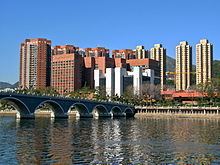
Sha Tin, also spelt Shatin, is an area around the Shing Mun River in the New Territories of Hong Kong. Administratively, it is part of the Sha Tin District.
Contents
- Hyatt regency hong kong sha tin nearby attractions in sha tin hong kong
- Map of Sha Tin Hong Kong
- Geography
- History
- Cross border activities
- Private housing estates
- Villages
- Shopping centres
- Notable places of worship
- Health
- Other facilities
- Education
- Culture sports and recreational facilities
- Local delicacies
- Transportation
- Roads
- Railway
- References
Map of Sha Tin, Hong Kong
Geography
Sha Tin is located in a valley, on both sides of the Shing Mun River, running from the southwest to the northeast. It is bordered by Tai Wai in the southwest and by Fo Tan (left bank) and Shek Mun (right bank) in the northeast.
History
Tai Wai Village, located in Tai Wai, next to Sha Tin, and the oldest and largest walled village in Sha Tin District, was built in 1574, during the Ming Dynasty.
Before British rule in Hong Kong, the area of Sha Tin and its vicinity was referred to as Lek Yuen (lit. "source of trickling" or "source of clear water"). Colonial officials allegedly mistook the name of the Sha Tin Wai village as the name of the area and it has been used ever since. Nowadays, the original name is used to refer to Lek Yuen Estate.
Sha Tin was formerly a market town at the present location of Sha Tin Centre Street and New Town Plaza shopping centre, near the Sha Tin Station of the MTR East Rail Line.
Sha Tin was the location of the first flight of a powered aircraft in Hong Kong in 1911. The aeroplane was named as the Spirit of Sha Tin (Chinese: 沙田精神號). A full size replica of this plane now hangs in Hong Kong International Airport.
The area was formerly agricultural farmland. Before Sha Tin's development into a new town, Hung Mui Kuk (紅梅谷), southwest of Sha Tin, was perennially the main site for school picnics. The valley remains a popular barbecue site.
Starting in the 1970s, the area became part of the Sha Tin New Town development. Since then, the economy in the area has greatly improved and living standards have also increased. Sha Tin Town Centre was developed during the mid-1980s to help "link the town's currently dispersed residents into one cohesive community." The 18-hectare site, adjacent to the railway station, was built up in stages to house an array of uses including the New Town Plaza, numerous smaller shopping centres, Sha Tin Park, magistracy, library, town hall, marriage registry, hotel, New Town Tower, a town square, and residential towers.
Cross-border activities
Due to their proximity to the Shenzhen border, towns in the northern parts of Hong Kong, notably Sheung Shui and Yuen Long, have become hubs for parallel traders who have been buying up large quantities of goods, forcing up local prices and disrupting the daily lives of local citizens. Since 2012, there has been a vertiginous increase in mainland parallel traders arriving in the North District of Hong Kong to re-export infant formula and household products – goods popular with mainlanders – across the border to Shenzhen. The volume of smuggling activity spilled over into Tuen Mun and Shatin in 2014.
The first anti-parallel trading protest was started at Sheung Shui in September 2012. As government efforts to limit the adverse impact of mainland trafficking were widely seen as inadequate, so there have been further subsequent protests in towns in the North District including Shatin.
Private housing estates
Private housing estates in Sha Tin include:
Villages
Right bank of Shing Mun River. From west to east:
Left bank of Shing Mun River. From west to east:
Shopping centres
Notable places of worship
Health
The Prince of Wales Hospital was officially opened in 1982. It provides about 1,400 hospital beds and 24 hours Accident & Emergency service to the eastern New Territories. Other institutions which provide hospital services include the Sha Tin Hospital, the Cheshire Home and the Union Hospital.
Other facilities
Education
At present, there are 46 primary and 44 secondary schools in Sha Tin and Ma On Shan. Tertiary institutions include Hong Kong Baptist University (Shek Mun Campus), the Chinese University of Hong Kong, the Heng Seng School of Commerce, The Institute Of Vocational Education - Sha Tin (IVE-ST) and the Hong Kong Sports Institute.
Culture, sports and recreational facilities
There are numerous cultural, recreational and sport facilities in Sha Tin including the Town Hall, swimming pools, football pitches, indoor recreation centres and various track and field facilities for the use of Sha Tin residents.
The 8-hectare Sha Tin Park was opened to public in 1988. Apart from its horticultural gardens and impressive water features, it also includes a large open plaza and a bandstand. The Ma On Shan Park, which is adjacent to Ma On Shan Swimming Pool, occupies 5.5 hectare of land.
The Sha Tin Racecourse, occupying approximately 70 hectares, rests on reclaimed flatland. At the centre of the racecourse is the Penfold Garden which opens to the public on non-racing days.
Located in Tai Wai, the Hong Kong Heritage Museum was opened at the end of 2000. Apart from introducing the art, culture and history of the New Territories, the museum also exhibits a variety of cultural artifacts for public appreciation. The museum, which can accommodate 6,000 visitors, is the largest in the territory.
Cycling has been a distinctive feature in Sha Tin and is very popular among both local people and visitors. The first cycle track in Sha Tin was opened to public in 1981, running along Tolo Highway to Tai Po, and this remains the territory's most popular cycling venue, drawing many occasional riders at the weekends, as well as dedicated cyclists. To tie in with the development of Ma On Shan, the cycle track was extended to Ma On Shan.
Hiking is also a wonderful activity you could do in your leisure time living in Sha Tin. There are several starting points including Hin Tin Village, Sha Tin Tau Village and hung mui kuk barbecue area leading to the track of Lion Rock Mountain hiking route. It would take you 1 hour to 4 hours to complete the track depends on the starting point and ending point you choose.
Local delicacies
Sha Tin is famous for certain southern Chinese food such as shanshui doufu (Chinese: 山水豆腐; lit. mountain-water beancurd), barbecued pigeon and chicken congee. The cooked food stalls in Wo Che Estate and Fo Tan are hotspots for food.
Transportation
There are numerous transportation links both within the Sha Tin District and connecting it to other places in Hong Kong.
Roads
The road network in Sha Tin is well developed to provide efficient cross-town and local access traffic. Connection between Sha Tin and Kowloon mainly relies on the Lion Rock Tunnel, Tate's Cairn Tunnel, Shing Mun Tunnel and Tai Po Road which makes it easy to reach from many areas of Kowloon as well as from Tsuen Wan.
At present, there are over 110 routes of public bus serving Sha Tin.