
Population 6,266 (2011) Civil parish Handforth Local time Wednesday 8:12 PM | OS grid reference SJ8583 Unitary authority Dialling code 01625 | |
 | ||
Weather 11°C, Wind SW at 5 km/h, 73% Humidity | ||
Handforth is a suburban town between Wilmslow, Heald Green and Styal in Cheshire, England. The population of the civil parish at the 2011 Census was 6,266. In the 1960s and 1970s, two overspill housing estates were built to re-house people from inner city Manchester, Spath Lane in Handforth and Colshaw Farm nearby in Wilmslow.
Contents
- Map of Handforth UK
- History
- Administrative history
- Geography
- Climate
- Physical geography
- Governance
- Population
- Ethnicity
- Religion
- Places of Worship
- Transport
- Economy
- Health
- Schools
- Police
- Fire
- Parks
- References
Map of Handforth, UK
History
Handforth, township and hamlet with ry. sta., Cheadle par., E. Cheshire, 5 miles SW. of Stockport, 1311 ac., pop. 736; P.O., T.O.
Handforth's original name was Handforth cum-Bosden, and for many years it was in the parish of Cheadle. The name "Handforth" is believed to originate from the Saxon Hanna's Ford, when there was a crossing on the River Dean. The first mention of Handforth is in a charter dated between 1233 and 1236.
During the Crusades, Handforth acquired its own Coat of Arms, which displays the Honford Star. The Honford Star originated from Henry de Honford who, while fighting in the Crusades, painted a silver star on his black shield after seeing a star fall from the sky during a night attack on the Saracens. The town was referred to as Honford in John Speede's map of the area in 1611, after the local feudal family known as the de Honford's.
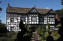
The oldest building in Handforth is Handforth Hall, a typically Tudor-styled black and white timber building built by Sir Urian Brereton in 1562. It was originally named Honford Hall after the de Honford's. Sir Urian was escheator of Cheshire, one of the privy grooms to King Henry and knighted in 1544 at Leith during an attack on Edinburgh. Sir Urian Brereton died at Handforth Hall on 19 March 1577 and is thought to be buried in a chapel at St Mary's Church, Cheadle. In the south chapel are three recumbent effigies. Two are in alabaster and are thought to represent members of the Hondford (or Handford) family, Sir John, who died in 1461 and his son, also named John. The third is in sandstone and represents Sir Thomas Brereton who died in 1673. The most famous resident of Handforth is Sir Urian's great grandson, the Parliamentary General, Sir William Bereton, who fought in the Civil War.
During the Second World War Handforth, along with Cheadle Hulme, was home to large parts of RAF Handforth. This was a maintenance unit, classed as a universal stores depot, and had the official Royal Air Force name RAF Handforth No 61 M.U. (Maintenance unit). The depot opened in 1939, closed in 1959 and covered large areas of land in both Handforth and neighbouring Cheadle Hulme.
The depot stored and dispatched every item that the RAF used in wartime, from knives and forks to aircraft engines. The site was served by a large, internal railway system which left the Manchester to Crewe mainline near Handforth railway station. The site of the exchange sidings and junction is at the rear of the Pets At Home offices on Epsom Avenue. The depot had its own shunting locomotives, which were stored in an engine shed that stood at the Wilmslow bound exit slip road for the Handforth Dean shopping centre.
The only surviving buildings of RAF Handforth are the government pay offices adjacent to the Total Fitness gym on Dairyhouse Lane. These buildings were the Headquarters of the depot and have survived in MoD use to this day.
In January 2017, government plans were announced to build a garden village on the eastern margin of Handforth village, to include 2,000 houses with facilities including a nursery and care home.
Administrative history
Handforth-cum-Bosden was part of the Stockport Registration District between 1837 and 1877, until it was divided onto the separate parishes of Handforth and Bosden. Handforth continued to be part of the Stockport Registration District from 1877 to 1936 when it was then incorporated into the parishes of Wilmslow and Cheadle and Gatley. The parish of Bosden was abolished in 1900 and incorporated into the parish of Hazel Grove and Bramhall.
Handforth along with other towns, such as Whitworth, Poynton and Alderley Edge, successfully objected to being part of the metropolitan county of Greater Manchester when it was formed in 1974, as a result of plans laid out in the Local Government Act 1972, although the area does form part of the Greater Manchester Urban Area. From 1974 until the changes in local government which occurred in 2009, Handforth was administered by both the Macclesfield Borough Council and also the Cheshire County Council. On 1 April 2009, it became part of the Cheshire East unitary authority.
Geography
Handforth borders Heald Green to the north and Wilmslow to the south, between the Cheshire Plain and the Pennines. The area lies near the River Dean, a tributary of the River Bollin that flows north–west and eventually joins the River Mersey near Lymm. The local geology is mostly glacial clay, as well as glacial sands and gravel.
The majority of buildings in the area are houses which date from the 20th or 21st centuries. However, there are a few buildings in the area that are earlier than that and date back to before the 20th century and as far as the 16th century (such as Handforth Hall).
Climate
Handforth experiences a temperate maritime climate, like much of the British Isles, with relatively cool summers and mild winters.
Physical geography
The eastern half of Cheshire, in which Handforth is located, is Upper Triassic Mercia Mudstone laid down with large salt deposits which were mined for hundreds of years around Northwich. Separating this area from Lower Triassic Sherwood Sandstone to the west is a prominent sandstone ridge known as the Mid Cheshire Ridge. A 55-kilometre (34 mi) footpath, the Sandstone Trail, follows this ridge from Frodsham to Whitchurch passing Delamere Forest, Beeston Castle and earlier Iron Age forts.
The highest point in Cheshire is Shining Tor on the Derbyshire/Cheshire border between Macclesfield and Buxton, at 559 metres (1,834 ft) above sea level. Before county boundary alterations in 1974, the county top was Black Hill (582 m (1,909 ft)) near Crowden in the far east of the historic county on the border with the West Riding of Yorkshire. Black Hill is now the highest point in West Yorkshire.
Governance
Handforth is situated in Cheshire East, a unitary authority area with borough status in the county of Cheshire. Handforth falls within the constituency of Tatton, a strongly Conservative constituency represented by George Osborne, the former Chancellor of the Exchequer. It is the third most affluent constituency in the UK outside of Kensington and Cities of London and Westminster. The area is also represented in the European Parliament by being part of the North West England constituency.
Population
The historic population of Handforth was 650 in 1851, and 911 in 1901. According to the United Kingdom Census 2011, the Handforth Ward has a population of 9,139 people. This is an increase from the data in the 2001 Census, when the Handforth Ward had a population of 8,014 people. The gender composition of Handforth is made up of 4,640 females (50.8%) and 4,499 males (49.2%).
Ethnicity
According to the 2011 Census, ethnic white groups (British, Irish, other) account for 8,375 (91.6%) of the population, against 96.8% in the previous 2001 census, with 8.4% (764 people) being in ethnic groups other than white.
Of the 8.4% (764 people) in non-white ethnic groups:
Religion
A breakdown of religious groups and denominations (2011 vs 2001):
Places of Worship
There are three churches in Handforth:
Methodist: St. Mary's Methodist Church was built in 1872, however Methodism was present in the Handforth and Wilmslow area long before this. It is recorded that John Wesley preached at nearby Finney Green on 1 September 1748.
Roman Catholic: St. Benedict's Roman Catholic Church, part of the Diocese of Shrewsbury.
Anglican: St. Chad's Church of England, which is part of the Diocese of Chester, is the Anglican Church based in Handforth. During the 19th century a Chapel of ease was built in Handforth, which was part of the Parish of Cheadle. It was consecrated in 1837 as a chapel to St Mary's Church, Cheadle, becoming the parish church for Handforth and part of Cheadle in 1877. Due to growth of the Handforth population in the late 19th century, the Church went through extensive redevelopment and expansion and the new St Chad's Church was consecrated by Francis Jayne, Bishop of Chester on St Chad's Day, 2 March 1899.
Transport
Handforth railway station is on a double-track electrified line that runs from Manchester Piccadilly to Crewe via Levenshulme, Cheadle Hulme, Stockport and Wilmslow. The A34 bypass is situated to the east and the main thoroughfare is Wilmslow Road (B5358). Manchester Airport lies just 3.5miles (6 km) to the north west, but Handforth lies away from the approach and departure routes and therefore suffers only slightly from aircraft noise.
Economy
Handforth Dean is a retail park that houses shops such as Tesco, Marks & Spencer and BHS, and is situated by the A34 bypass. Pets at Home has its headquarters based in Handforth.
Health
Handforth Health Centre, purpose built in 1975, was purchased from the Health Authority by the GPs in 1992 and completely refurbished.
Schools
Handforth is served by three primary schools: Wilmslow Grange, Dean Oaks Primary and St. Benedict's RC Primary.
Police
Handforth is served by Cheshire Constabulary, with the closest branch being based in Wilmslow.
Fire
Cheshire Fire and Rescue Service is the fire service that caters for Handforth, with the nearest fire station being located in Wilmslow.
Parks
Meriton Road Park, opened in 1935, covers an area of 3.4 hectares (9 acres) and is situated to the rear of the Paddock Shopping Centre. Until the mid-1980s the park was the site for the Handforth Gala. Current attractions in the park include a multi-sport court, tennis courts and a miniature railway which is operated by Handforth Model Engineering Society.
Stanley Hall Park is situated between the Spath Lane Estate and the railway line from Handforth to Cheadle Hulme. The park was donated by Manchester City Council in the early 1960's. The park is owned and maintained by Cheshire East Councils environmental partner Ansa and has an active friends of the park group. Facilities include the Swingtime play areas and muga both donated by Spath Lane Residents Association and a 52 seat all inclusive picnic area with space for 15 wheelchairs or buggies and a concrete skatepark installed by the Friends of Stanley Hall Park in 2015/16.