
Length 267 km | ||
 | ||
Sources Stonecoal Creek, Devils Fork, Winding Gulf | ||
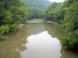
The Guyandotte River is a tributary of the Ohio River, approximately 166 mi (267 km) long, in southwestern West Virginia in the United States. It was named after the French term for the Wendat Native Americans. It drains an area of the unglaciated Allegheny Plateau south of the Ohio between the watersheds of the Kanawha River to the northeast and Twelvepole Creek and the Big Sandy River to the southwest. Via the Ohio River, it is part of the Mississippi River watershed.
Contents
- Map of Guyandotte River West Virginia USA
- CourseEdit
- DamsEdit
- TributariesEdit
- Upper Guyandotte Watershed AssociationEdit
- Cities and towns along the Guyandotte RiverEdit
- Variant namesEdit
- References
Map of Guyandotte River, West Virginia, USA
CourseEdit
The Guyandotte River is formed in southwestern Raleigh County by the confluence of three streams, Winding Gulf, Stonecoal Creek, and the Devils Fork. and flows initially west-northwestwardly into Wyoming and Mingo counties. It turns briefly northward in Mingo County and enters Logan County, where it turns north-northwestwardly for the remainder of its highly meandering course through Logan, Lincoln and Cabell counties. It enters the Ohio River from the south at Huntington, about 5 mi (8 km) east of the city's downtown.
DamsEdit
A U.S. Army Corps of Engineers dam in Mingo County causes the river to widen as R.D. Bailey Lake in Mingo and western Wyoming Counties.
TributariesEdit
The Mud River joins the Guyandotte at Barboursville in Cabell County. The Slab Fork joins the Guyandotte in downtown Mullens in Wyoming County. Big Ugly Creek joins the Guyandotte in Lincoln County.
Upper Guyandotte Watershed AssociationEdit
In Mullens, an active watershed organization is working to reduce pollution in the headwaters of the Guyandotte River. The Upper Guyandotte Watershed Association (UGWA) is a grassroots, community-based organization working to reduce sources of pollution in order to clean up streams and make the watershed a better place to live. UGWA has garnered much public support and produced results in partnering with numerous local, state, and federal agencies.
Cities and towns along the Guyandotte RiverEdit
Variant namesEdit
According to the Geographic Names Information System (GNIS), the Guyandotte River has also been known as: