
Area 2.35 million km² | ||
 | ||
Surface area 2,350,000 km (910,000 sq mi) | ||
The Gulf of Guinea is the northeasternmost part of the tropical Atlantic Ocean between Cape Lopez in Gabon, north and west to Cape Three Points in Western region Ghana. The intersection of the Equator and Prime Meridian (zero degrees latitude and longitude) is in the gulf.
Contents
- Map of Gulf of Guinea
- Name
- Geography
- Islands in the Gulf of Guinea
- Annobn
- Bobowasi Island
- Bioko
- Corisco
- The Elobeys
- So Tom and Prncipe
- References
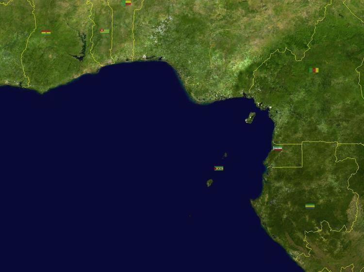
Map of Gulf of Guinea
Among the many rivers that drain into the Gulf of Guinea are the Niger and the Volta. The coastline on the gulf includes the Bight of Benin and the Bight of Bonny.
The Niger River in particular deposited organic sediments out to sea over millions of years which became crude oil. The Gulf of Guinea region, along with the Congo River delta and Angola further south, are expected to provide around a quarter of the United States' oil imports by 2015. This region is now regarded as one of the world's top oil and gas exploration hotspots.
Name
The origin of the name Guinea is thought to be an area in the region, although the specifics are disputed. Bovill (1995) gives a thorough description:
The name Guinea is usually said to have been a corrupt form of the name Ghana, picked up by the Portuguese in the Maghrib. The present writer finds this unacceptable. The name Guinea has been in use both in the Maghrib and in Europe long before Prince Henry's time. For example, on a map dated about 1320 by the Genoese cartographer Giovanni di Carignano, who got his information about Africa from a fellow-countryman in Sijilmas [ancient trading city in North Africa], we find Gunuia, and in the Catalan atlas of 1375 as Ginyia. A passage in Leo [Africanus] (vol. III, 822) points to Guinea having been a corrupt form of Jenne [2,000-year-old city in central Mali on Niger river], less famous than Ghana but nevertheless for many centuries famed in the Maghrib as a great market and a seat of learning. The relevant passage reads: "The Kingdom of Ghinea . . . called by the merchants of our nation Gheneoa, by the natural inhabitants thereof Genni and by the Portugals and other people of Europe Ghinea." But it seems more probable that Guinea derives from aguinaou, the Berber for Negro. Marrakech [city in southeastern Morocco] has a gate, built in the twelfth century, called the Bab Aguinaou, the Gate of the Negro (Delafosse, Haut-Sénégal-Niger, II, 277-278). The modern application of the name Guinea to the coast dates only from 1481. In that year the Portuguese built a fort, São Jorge da Mina (modern day Elmina), on the Gold Coast region, and their king, John II, was permitted by the Pope [Sixtus II or Innocent VIII] to style himself Lord of Guinea, a title that survived until the recent extinction of the monarchy.
The name "Guinea" was also applied to south coast of West Africa, north of the Gulf of Guinea, which became known as "Upper Guinea", and the west coast of Southern Africa, to the east, which became known as "Lower Guinea." The name "Guinea" is still attached to the names of three countries in Africa: Guinea, Guinea-Bissau, and Equatorial Guinea, as well as New Guinea in Melanesia.
Geography
The main river shedding its waters in the gulf is the Niger River.
There are different definitions of the geographic limits of the gulf of Guinea; the International Hydrographic Organization defines the southwest extent of the Gulf of Guinea as "A line running Southeastward from Cape Three Points in Western region Ghana (4.744°N 2.089°W / 4.744; -2.089) to Cape Lopez in Gabon (0°38′S 8°42′E)".
Islands in the Gulf of Guinea
The Gulf of Guinea contains a number of islands, the largest of which are in a southwest-northeast chain, forming part of the Cameroon line of volcanoes.
Annobón
Annobón, also known as Pagalu or Pigalu, is an island that is part of Equatorial Guinea.
Bobowasi Island
Bobowasi Island is an island off the west coast of Africa in the Gulf of Guinea that is part of Western region Ghana.
Bioko
Bioko is an island off the west coast of Africa in the Gulf of Guinea that is part of Equatorial Guinea.
Corisco
Corisco is an island belonging to Equatorial Guinea.
The Elobeys
Elobey Grande and Elobey Chico are two small islands belonging to Equatorial Guinea.
São Tomé and Príncipe
São Tomé and Príncipe (officially the Democratic Republic of São Tomé and Príncipe) is a Portuguese-speaking island nation in the Gulf of Guinea that became independent from Portugal in 1975. It is located off the western equatorial coast of Africa and consists of two islands, São Tomé and Príncipe. They are located about 140 kilometres (87 mi) apart and about 250 and 225 kilometres (155 and 140 mi), respectively, off the northwestern coast of Gabon. Both islands are part of an extinct volcanic mountain range. São Tomé, the sizeable southern island, is situated just north of the Equator.