
Basin area 407,093 km² Bridges Adomi Bridge | Length 1,600 km Discharge 1,210 m³/s | |
 | ||
- average 1,210 m/s (42,731 cu ft/s) Basin 407,093 km2 (157,179 sq mi) Mouths | ||
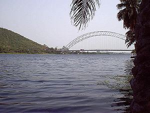
Volta river estuary ada ghana
The Volta River is a river, primarily flowing in Volta Region and Dagbon in the Northern Region of Ghana, that drains into the Atlantic Ocean at the Gulf of Guinea in Ada. It has three main tributaries—the Black Volta, White Volta and Red Volta.
Contents
- Volta river estuary ada ghana
- Map of Volta River Ghana
- Weeds on volta river nature or spirits
- Reservoir
- History
- References
Map of Volta River, Ghana
Weeds on volta river nature or spirits
Reservoir
Lake Volta is a reservoir impounded by the Akosombo Dam on the lower Volta River in southern Ghana. It is one of the largest reservoirs in the world. It extends from the Akosombo Dam in southeastern Ghana to the town of Yapei in Dagbon, some 400 kilometres (250 mi) to the north.
The reservoir's dam generates electricity for the Volta River Authority, and the reservoir provides inland water transport routes. It may be a resource for irrigation and fish farming.
The depth of the river is 45 feet (14 m) below Lake Volta. The Volta River is crossed by the Adome Bridge below the Akosombo Dam and the reservoir.
History
The Volta River was named by Portuguese gold traders in Ghana. It was their farthest extent of exploration before returning (volta is Portuguese for "twist" or "turn"). "River of return" (perhaps because it was where ships turned around and headed for home) or “river of bend,” in reference to its course.