
 | ||
The Great Wagon Road was an improved trail through the Great Appalachian Valley from Pennsylvania to North Carolina, and from there to Georgia in colonial America.
Contents
- Map of Great Wagon Rd Fort Mill SC 29715 USA
- Introduction
- Great Wagon Road Philadelphia to Roanoke Virginia circa 1754 approximately 395 miles 636km
- Great Wagon Road Roanoke Virginia to Wachovia North Carolina Circa 1754 Approximately 128 miles 206km
- Great Wagon Road Wachovia via the Trading Ford to Salisbury North Carolina Circa 1765 Approximately 46 miles 74km
- Great Wagon Road Wachovia via the Shallow Ford to Salisbury North Carolina Circa 1765 Approximately 55 miles 89km
- Great Wagon Road Salisbury North Carolina to Charlotte North Carolina Circa 1775 Approximately 38 miles 61km
- Great Wagon Road Charlotte North Carolina to Augusta Georgia via Camden and Columbia South Carolina Circa 1775 Approximately 190 miles 310km
- Great Wagon Road Charlotte North Carolina to the Broad River South Carolina Circa 1775 Approximately 76 miles 122km
- Great Wagon Road The Broad River South Carolina to Augusta Georgia via Columbia South Carolina circa 1775 Approximately 134 miles 216km
- Great Wagon Road The Broad River South Carolina to Augusta Georgia via Ware Shoals South Carolina Circa 1775 Approximately 145 miles 233km
- References
Map of Great Wagon Rd, Fort Mill, SC 29715, USA
Introduction
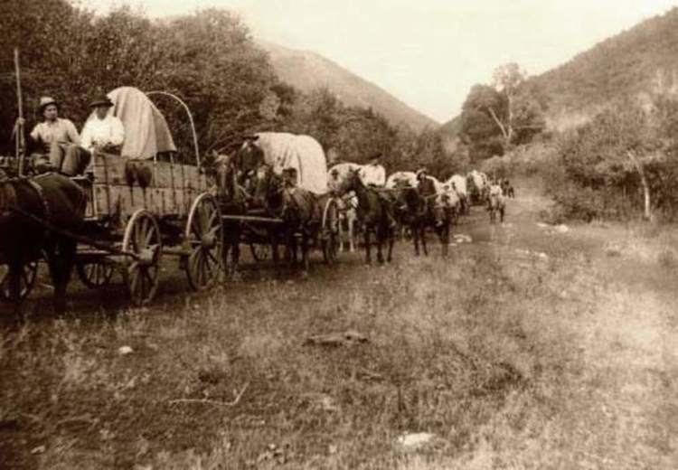
The heavily traveled Great Wagon Road was the primary route for the early settlement of the Southern United States, particularly the "backcountry". Although a wide variety of settlers traveled southward on the road, two dominant cultures emerged. The German Palatines and Scotch-Irish American immigrants arrived in huge numbers because of unendurable conditions in Europe. The Germans (also known as Pennsylvania Dutch) tended to find rich farmland and work it zealously to become stable and prosperous. The other group (known also as Presbyterian or Ulster Scots) tended to be restless, clannish, and fiercely independent; they formed what became known as the Appalachian Culture. Partly because of the language difference, the two groups tended to keep to themselves.
Beginning at the port of Philadelphia, where many immigrants entered the colonies, the Great Wagon Road passed through the towns of Lancaster and York in southeastern Pennsylvania.
Turning southwest, the road crossed the Potomac River and entered the Shenandoah Valley near present-day Martinsburg, West Virginia. It continued south in the valley via the Great Warriors' Trail (also called the Indian Road, as on this map), which was established by centuries of Indian travel over ancient trails created by migrating buffalo herds. The Shenandoah portion of the road is also known as the Valley Pike. The Treaty of Lancaster in 1744 had established colonists' rights to settle along the Indian Road. Although traffic on the road increased dramatically after 1744, it was reduced to a trickle during the French and Indian War (Seven Years' War) from 1756 to 1763. But after the war ended, it became the most heavily traveled road in America.
South of the Shenandoah Valley, the road reached the Roanoke River at the town of Big Lick (today, Roanoke). South of Roanoke, the Great Wagon Road was also called the Carolina Road. At Roanoke, a road forked southwest, leading into the upper New River Valley and on to the Holston River in the upper Tennessee Valley. From there, the Wilderness Road led into Kentucky, ending at the Ohio River where flatboats were available for further travel into the Midwest and even to New Orleans.
From Big Lick/Roanoke, after 1748, the Great Wagon Road passed through the Maggoty Gap (also called Maggodee) to the east side of the Blue Ridge Mountains. Continuing south through the Piedmont region, it passed through the present-day North Carolina towns of Winston-Salem, Salisbury, and Charlotte and sites of earlier Indian settlements on the historic Indian Trading Path. The Great Wagon Road ultimately reached Augusta, Georgia, on the Savannah River, a distance of more than 800 miles (1,300 km) from Philadelphia.
Despite its current name, the southern part of this road was by no means passable by wagons until later colonial times. The 1751 Fry-Jefferson map on this page notes the term "Waggon" only north of Winchester, Virginia. In 1753, a group of wagon travelers reported that "the good road ended at Augusta" (now Staunton, Virginia), although they did keep going all the way to Winston-Salem. By all accounts, it was never a comfortable route. The lines of settlers' covered wagons moving south were matched by a line of wagons full of agricultural produce heading north to urban markets; these were interspersed with enormous herds of cattle, hogs, and other livestock being driven north to market. Although there surely would have been pleasant areas for travel, road conditions also could vary from deep mud to thick dust, mixed with animal waste. Inns generally provided only the most basic food and a space to sleep.
Today, it is possible to experience many segments of the old road by car, by bike, or even on foot. Although most of the road has seen profound changes, some areas retain scenery much as the pioneers encountered it.
Great Wagon Road: Philadelphia to Roanoke, Virginia (circa 1754) – approximately 395 miles (636 km)
(Click here for a map from Google: "Philadelphia/Roanoke Map". Then zoom in and drag for details; also click on the small inset in the map to get a satellite view.)
Note: The segments and distances are approximations; actual paths varied constantly with fallen trees, floods, etc.
Beginning at Philadelphia, Pennsylvania:
Great Wagon Road: Roanoke, Virginia to Wachovia, North Carolina (Circa 1754) -- Approximately 128 miles (206 km)
(Click here for a map from Google: "Roanoke / Wachovia Map". Then zoom in and drag for details; also click on the small inset in the map to get a satellite view.)
Note: The segments and distances are approximations; actual paths varied constantly with fallen trees, floods, etc.Continue south at Roanoke, Virginia:
Great Wagon Road: Wachovia via the Trading Ford to Salisbury, North Carolina (Circa 1765) -- Approximately 46 miles (74 km)
(Click here for a map from Google: "Wachovia / Salisbury Map". Then zoom in and drag for details; also click on the small inset in the map to get a satellite view.)
Note: The segments and distances are approximations; actual paths varied constantly with fallen trees, floods, etc.Continue south at Wachovia, North Carolina:
Great Wagon Road: Wachovia via the Shallow Ford to Salisbury, North Carolina (Circa 1765) -- Approximately 55 miles (89 km)
(Click here for a map from Google: "Wachovia / Salisbury Map". Then zoom in and drag for details; also click on the small inset in the map to get a satellite view.)
Note: The segments and distances are approximations; actual paths varied constantly with fallen trees, floods, etc.Continue south at Wachovia, North Carolina:
Great Wagon Road: Salisbury, North Carolina to Charlotte, North Carolina (Circa 1775) -- Approximately 38 miles (61 km)
(Click here for a map from Google: "Salisbury/Charlotte Map". Then zoom in and drag for details; also click on the small inset in the map to get a satellite view.)
Note: The segments and distances are approximations; actual paths varied constantly with fallen trees, floods, etc.Continue south at Salisbury, North Carolina:
Great Wagon Road: Charlotte, North Carolina to Augusta, Georgia via Camden and Columbia, South Carolina (Circa 1775) -- Approximately 190 miles (310 km)
(Click here for a map from Google: "Charlotte/Camden/Augusta Map". Then zoom in and drag for details; also click on the small inset in the map to get a satellite view.)
Note: The segments and distances are approximations; actual paths varied constantly with fallen trees, floods, etc.Continue south at Charlotte, North Carolina:
Great Wagon Road: Charlotte, North Carolina to the Broad River, South Carolina (Circa 1775) -- Approximately 76 miles (122 km)
(Click here for a map from Google: "Charlotte / Broad River (Carlisle) Map". Then zoom in and drag for details; also click on the small inset in the map to get a satellite view.)
Note: The segments and distances are approximations; actual paths varied constantly with fallen trees, floods, etc.Continue south at Charlotte, North Carolina:
Great Wagon Road: The Broad River, South Carolina to Augusta, Georgia, via Columbia, South Carolina (circa 1775) -- Approximately 134 miles (216 km)
(Click here for a map from Google: "Broad River (Carlisle) / Columbia / Augusta Map". Then zoom in and drag for details; also click on the small inset in the map to get a satellite view.)
Note: The segments and distances are approximations; actual paths varied constantly with fallen trees, floods, etc.Continue south at the Broad River ford, North Carolina:
Great Wagon Road: The Broad River, South Carolina to Augusta, Georgia, via Ware Shoals, South Carolina (Circa 1775) -- Approximately 145 miles (233 km)
(Click here for a map from Google: "Broad River (Whitmire) / Ware Shoals / Augusta Map". Then zoom in and drag for details; also click on the small inset in the map to get a satellite view.)
Note: The segments and distances are approximations; actual paths varied constantly with fallen trees, floods, etc.Continue south at the Broad River ford, North Carolina: