
Historical era Colonial Era Preceded by Succeeded by Currency Pound sterling | Established December 7, 1710 Founded 7 December 1710 Date dissolved 1776 | |
 | ||
The Province of North Carolina was originally part of the Province of Carolina, which was chartered by eight Lords Proprietor. The province later became the U.S. states of North Carolina and Tennessee, and parts of the province combined with other territory to form the states of Georgia, Alabama, and Mississippi.
Contents
History
For history prior to 1729, see Province of Carolina.
King Charles II of England granted the Carolina charter in 1663 for land south of Virginia Colony and north of Spanish Florida. Charles II granted the land to eight Lords Proprietors in return for their financial and political assistance in restoring him to the throne in 1660. Because the northern half of the colony differed significantly from the southern half, and because transportation and communication between the two settled regions was difficult, a separate deputy governor was named to administer the northern half of the colony starting in 1691.
The division of the colony into North and South was completed at a meeting of the Lords Proprietors held at Craven House in London on December 7, 1710, although the same proprietors continued to control both colonies. The first Governor of the separate North Carolina Province was Edward Hyde.
Unrest against the proprietors in South Carolina in 1719 led to the appointment of a royal governor in that colony by King George I, whereas the Lords Proprietor continued to appoint the governor of North Carolina.
In 1729, after nearly a decade-long attempt by the British government to locate and buy out seven of the eight Lords Proprietors, both Carolinas became royal colonies. The remaining one-eighth share of the Province (part of North Carolina known as the Granville District) was retained by members of the Carteret family until 1776.
Expansion westward from the province's seats of power on the coast began early in the 18th Century, particularly after the conclusion of the Tuscarora and Yamasee wars, in which the largest barrier to colonial settlement further inland was removed. The French and Indian War, and the accompanying Anglo-Cherokee War in which the two remaining major tribes in the province—the Cherokee and Catawba—were effectively neutralized made settlement in large numbers over the Appalachian Mountains more feasible. In order to stifle potential conflict with natives in that region, including the Cherokee, King George III issued the Proclamation of 1763, barring settlers in any of the provinces of North America from settling near the headwaters of any rivers or streams that flowed westward towards the Mississippi River. This included several North Carolina rivers, including the French Broad and Watauga. While this proclamation was not strictly obeyed, and was widely detested in North Carolina, the edict likely served to delay immigration into what is now Tennessee by large masses of people until after the American Revolutionary War.
Settlers continued to flow westwards in smaller numbers, despite the prohibition against doing so, and as a result several trans-Appalachian settlements were formed. Most prominently, the Watauga Association formed in 1772 as an ostensibly-independent territory within the bounds of North Carolina (now modern-day Tennessee), which adopted its own written constitution. Prominent frontiersmen like Daniel Boone traveled back and forth across the invisible proclamation line as market hunters, seeking valuable pelts to sell in eastern settlements, but eventually served as leaders and guides for small groups of immigrants who settled in the areas that are now Tennessee and Kentucky.
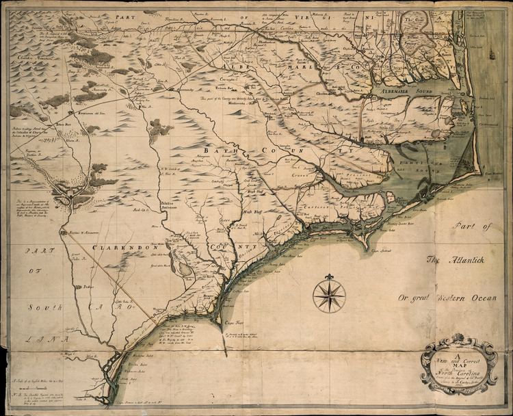
Maps
Two important maps of the province were reproduced: one by Edward Moseley in 1733, and another by John Collet in 1770. Other maps exist dating to the early period of the Age of Discovery that depict portions of the province, or, more specifically, the coastline of the province along with that of South Carolina.
Judiciary
The Court Act of 1746 established a supreme court, initially known as the General Court, which sat twice a year at New Bern, consisting of a Chief Justice and three Associate Justices.