
Continent Americas Area Ranked 132nd | Coordinates 19°00' N 70°40' W Coastline 1,288 km (800 mi) | |
 | ||
Region CaribbeanGreater Antilles Borders Total land borders:275 km | ||
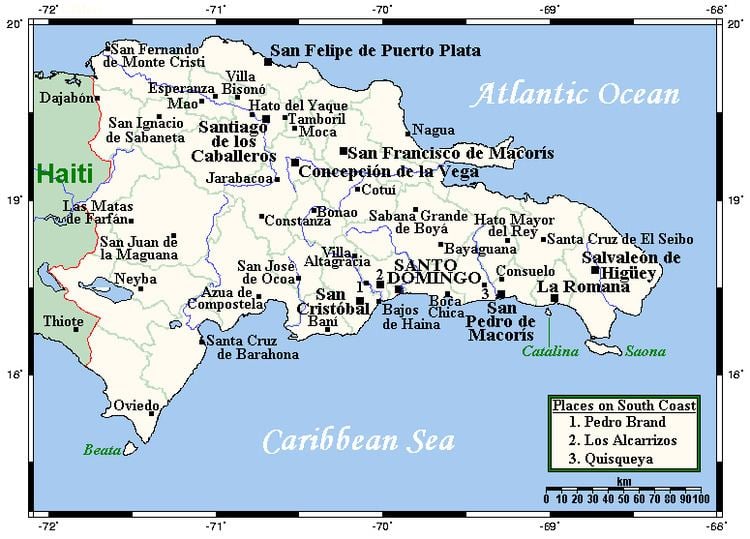
The Dominican Republic (Spanish: República Dominicana) is a country in the West Indies that occupies the eastern five-eighths of Hispaniola. It has an area of 48,670 km², including offshore islands. The land border shared with Haiti, which occupies the western three-eighths of the island, is 376 km long. The maximum length, east to west, is 390 km from Punta de Agua to Las Lajas, on the border with Haiti. The maximum width, north to south, is 265 km from Cape Isabela to Cape Beata. The capital, Santo Domingo, is located on the south coast.
Contents
The Dominican Republic's shores are washed by the Atlantic Ocean to the north and the Caribbean Sea to the south. The Mona Passage, a channel about 130 km wide, separates the country (and Hispaniola) from Puerto Rico.
Statistics
Climate
The country is a tropical, maritime nation. Conditions are ameliorated in many areas by elevation and by the northeast trade winds, which blow steadily from the Atlantic all year long. The annual mean temperature is 25 °C (77 °F); regional mean temperatures range from 18 °C (64.4 °F) in the heart of the Cordillera Central (Constanza) to as high as 27 °C (80.6 °F) in arid regions. Temperatures rarely rise above 32 °C (89.6 °F), and freezing temperatures only occur in winter in the highest mountains. The average temperature in Santo Domingo in January is 24 °C (75.2 °F), and 27 °C (80.6 °F) in July.
The rain season for the northern coast is from November to January. For the rest of the country, the rain season is from May to November. The average annual rainfall is 1,346 mm (53.0 in), with extremes of 2,500 mm (98.4 in) or more in the mountainous northeast (the windward side of the island) and 500 mm (19.7 in) in the southwestern valleys. The western valleys, along the Haitian border, remain relatively dry, with less than 760 mm (29.9 in) of annual precipitation, due to the rain shadow effect caused by the central and northern mountain ranges. The northwestern and southeastern extremes of the country are also arid.
The Dominican Republic is occasionally damaged by tropical storms and hurricanes, which originate in the mid-Atlantic and southeastern Caribbean from June until November (mainly from August to October) each year.
Islands
There are several smaller islands and cays that are part of the Dominican territory. The largest islands are:
- Saona, close to the southeastern coast of the Hispaniola, in the Caribbean Sea. It has an area of 117 km². Its Taíno name was Iai or Adamanay. Columbus named this island as Savona after the Italian city of the same name but the use during years has eliminated the letter v.
- Beata, in the southern coast of the Hispaniola, in the Caribbean Sea. It has an area of 27 km². Its Taíno name is unknown. Columbus named this island as Madama Beata.
- Catalina, very close to the southeastern coast of the Hispaniola, in the Caribbean Sea. It has an area of 9.6 km². Its Taíno name was Iabanea but some writers, including poets, say that it was called Toeya or Toella. It was discovered by Columbus who named it Santa Catalina.
Relief
The Dominican Republic is a country with many mountains, and the highest peaks of the West Indies are found here. The chains of mountains show a direction northwest-southeast, except in the Southern peninsula (in Haiti) where they have a direction west-east. The mountains are separated by valleys with the same general direction.
From north to south, the mountain ranges and valleys are:
Rivers and lakes
The 8 longest rivers of the Dominican Republic are:
- Yaque del Norte. With 296 km, it is the longest river of the Dominican Republic. Its sources are in the Cordillera Central and flows to the Atlantic Ocean. Its watershed has an area of 7,044 km².
- Yuna. It is 209 km long. Its sources are in the Cordillera Central and flows to the east into Samaná Bay. Its watershed has an area of 5,498 km².
- Yaque del Sur. It is 183 km long and its sources are in the Cordillera Central. It flows to the south into the Caribbean Sea. Its watershed has an area of 4,972 km².
- Ozama. It is 148 km long. Its sources are in Sierra de Yamasá (a branch of the Cordillera Central). It flows into the Caribbean Sea. Its watershed has an area of 2,685 km².
- Camú. It is 137 km long. Its sources are in the Cordillera Central and flows into the Yuna River. Its watershed has 2,655 km².
- Nizao. It is 133 km long. Its sources are in the Cordillera Central and flows to the south into the Caribbean Sea. Its watershed has an area of 974 km².
- San Juan. It is 121 km long. Its sources are in the Cordillera Central and flows to the south into the Yaque del Sur River. Its watershed has an area of 2,005 km².
- Mao. It is 105 km long. Its sources are in the Cordillera Central and flows to the north into the Yaque del Norte River. Its watershed has an area of 864 km².
The Artibonite River is the longest river of the island but only 68 km are in the Dominican Republic.
The largest lake of the Hispaniola, and of the West Indies, is the Lake Enriquillo. It is located in the Hoya de Enriquillo with an area of 265 km². There are three small islands within the lake. It is around 40 meters below sea level and is a saline lake with a higher concentration of salt than the sea water.
Others lakes are Rincón (fresh water, area of 28.2 km²), Oviedo (brackish water, area of 28 km²), Redonda, Limón.