
Continent Africa Area Ranked 150th | Region Horn of Africa Coastline 314 km (195 mi) | |
 | ||
Highest point Mousa Ali Volcano2,028 m | ||
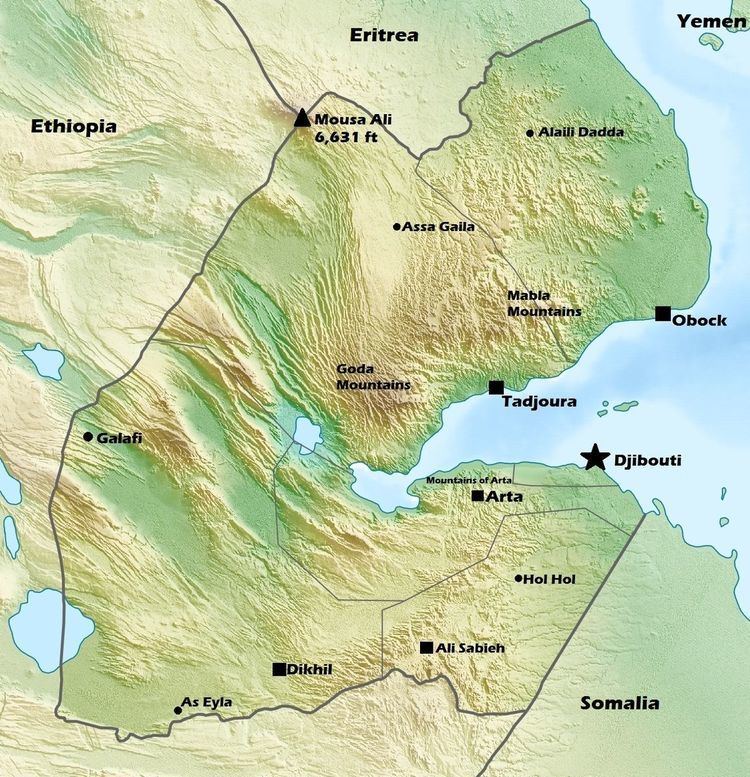
Djibouti is a country in the Horn of Africa. It is bordered by Eritrea in the north, Ethiopia in the west and south, and Somalia in the southeast. To the east is its coastline on the Red Sea and the Gulf of Aden. Rainfall is sparse, and most of the territory has a semi-arid or arid environment. Lake Assal is a saline lake which lies 155 m (509 ft) below sea level, making it the lowest point on land in Africa and the third-lowest point on Earth after the Sea of Galilee and the Dead Sea. Djibouti's major settlements include the capital Djibouti City, the port towns of Tadjoura and Obock, and the southern cities of Ali Sabieh and Dikhil. It is the 151st largest country in the world by land area, covering a total of 23,200 km2, of which 23,180 km2 is land and 20 km2 is water.
Contents
Location
Djibouti shares 127 kilometres (79 mi) of border with Eritrea, 344 kilometres (214 mi) with Ethiopia, and 63 kilometres (39 mi) with Somalia (total 530 km or 330 mi). It has a strategic location on the Horn of Africa and the Bab el Mandeb, along a route through the Red Sea and Suez Canal. Djibouti's coastline serves as a commercial gateway between the Arabian Peninsula and the Horn region's interior. The country is also the terminus of rail traffic into Ethiopia.
Physiographic regions
Djibouti can be divided into four physiographic regions
- The Northern Mountains
- Danakil Depression
- Grand Bara
- The Southern Mountains
Mountains
A great arc of mountains, consisting of the Mousa Ali, Goda Mountains, and Arrei Mountains surrounds Djibouti.
Djibouti has eight mountain ranges with peaks of over 1,000 m (3,281 ft).
Grand Bara
The Grand Bara Desert covers parts of South Djibouti in Arta Region, Ali Sabieh Region and Dikhil Region. The majority of the Grand Bara Desert lies at a relatively low elevation, below 1,700 feet (560 m). Home of the popular Grand Bara footrace.
Coasts
Most of Djibouti has been described as part of the Ethiopian xeric grasslands and shrublands ecoregion. The exception is a strip along the Red Sea coast, which is part of the Eritrean coastal desert; it is noted as an important migration route for birds of prey.
Djibouti Regions
The area of the regions of Djibouti is set out in the table below.
Climate
There is not much seasonal variation in Djibouti's climate. Hot conditions prevail year-round along with winter rainfall. Mean daily maximum temperatures range from 32 to 41 °C (90 to 106 °F), except at high elevations. In Djibouti city, for instance, afternoon highs in April typically range from 28 °C (82 °F) to 34 °C (93 °F) in April. Nationally, mean daily minima generally vary between sites from about 15 to 30 °C (59 to 86 °F). The greatest range in climate occurs in eastern Djibouti, where temperatures sometimes surpass 41 °C (106 °F) in July on the littoral plains and fall below freezing point during December in the highlands. In this region, relative humidity ranges from about 40% in the mid-afternoon to 85% at night, changing somewhat according to the season.
Djibouti has either a hot semi-arid climate (BSh) or a hot desert climate (BWh), although temperatures are much moderated at the high elevations. On the eastern seaboard, annual rainfall is less than 5 inches (131 mm); in the central highlands, it is about 8 to 11 inches (200 to 300 mm). Although the coastal regions are hot and humid throughout the year, the hinterland is typically hot and dry. The climate conditions are highly variable within the country and vary locally by altitude. Summers are very humid along the coast but dry in the highlands. Heat waves are frequent. Annual precipitation amounts vary greatly from one year to another. In general, rain falls more frequently and extensively in the mountains. Sudden and brutal storms are also known to occur. Wadis turn for a few hours into raging torrents tearing everything in their path, and their course is regularized. Rainwater serves as an additional water supply for livestock and plants alongside seasonal watercourses. The highlands have temperate climate throughout out the year. The climate of most lowland zones is arid and semiarid.
The climate of the interior shows notable differences from the coastline. Especially when one rises, the temperature is pleasant: it is so in Arta, Randa and Day (where temperatures of 10 ° have been recorded).
Selected elevations of notable locations
Lake Assal is the lowest point in Africa (the second lowest is the Qattara Depression in Northern Egypt).
Environment
Natural hazards include earthquakes, drought, and occasional cyclonic disturbances from the Indian Ocean, which bring heavy rains, and flash floods. Natural resources include geothermal energy. Inadequate supplies of potable water, limited arable land and desertification are current issues.
Djibouti is a party to international agreements on biodiversity, climate change, desertification, endangered species, Law of the Sea, ozone layer protection, ship pollution, and wetlands.
Maritime claims
Human geography
As of 2015, the population of Djibouti is 846 thousand.
For statistical purposes, the country has three areas; Djibouti City (population 529,000), Ali Sabieh (population 55,000), and Dikhil (population 54,000). Djibouti's population is diverse demographically; 60% Somali, 35% Afar, and 3% Arabs. In terms of religion, 94% Muslim, 6% Christian.
Extreme points
This is a list of the extreme points of Djibouti, the points that are farther north, south, east or west than any other location.