
Elevation 1,301 m | ||
 | ||
Similar Goda Mountains, Mabla Mountains, Mousa Ali | ||
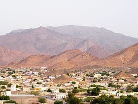
The Arrei Mountains also known as the "Roof of Ali Sabieh", are a mountain range in the southern Ali Sabieh Region in Djibouti. With an average elevation of 1,301 metres (4,268 ft) above sea level, is the four highest point in Djibouti, they are situated near the border with Ethiopia. The mountains constitute the highest point in Ali Sabieh region. The Issa Somali have a long history in the Arrei Mountains.
Contents
Map of Arrei Mountains, Ethiopia
History
In 1915, the Ethio-Djibouti Railways traversed the local Ali Sabieh.
It is the main town in the region, and is located 7 km northwest. The area is predominantly inhabited by the Issa Somali.
Fauna
A number of birds are found in the mountains including Egyptian vulture. Other endemic species include a number of geckos and lizards.
Climate
Arrei Mountain's altitude and location and topography frequently lead to cool and cloudy weather conditions, which can pose a danger to ill-equipped walkers. The Arrei Mountains receives the bulk of its precipitation between the months of June and mid-September, averaging just under 258 mm of rainfall annually. The fog was present on the summit for almost 75% of the time between November and January, and 6% of the time in March and August. Arrei Mountains receives additional precipitation in the form of fog and summer rains.