
Country Capital | Largest city Area 4,971.76 km2 | |
 | ||
Destinations Points of interest Hoge Veluwe National Park, Kroller-Muller Museum, Airborne Museum Hartenstein, Het Loo Palace, Apenheul Primate Park | ||
Population 2.02 million (Jan 1, 2014) | ||
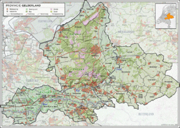
Map of Gelderland
Gelderland ( [ˈɣɛldərˌlɑnt], also Guelders in English) is a province of the Netherlands, located in the central eastern part of the country. With a land area of nearly 5,000 km2, it is the largest province of the Netherlands and shares borders with six other provinces and Germany.
Contents
- Map of Gelderland
- Trouwreportage in tiel gelderland judith raymond door allroundfoto
- Netherlands six castles in gelderland hd video
- History
- Geography
- Municipalities
- Abolished municipalities
- References
The capital is Arnhem. However, both Nijmegen and Apeldoorn are larger cities, Nijmegen being the largest with nearly 170,000 inhabitants. Other major regional centres in Gelderland are Ede, Doetinchem, Zutphen, Tiel, Wageningen, Zevenaar, Winterswijk and Harderwijk.
Gelderland had a population of just over two million in 2015.
Trouwreportage in tiel (gelderland) judith & raymond door @allroundfoto
Netherlands six castles in gelderland hd video
History
Historically, the province dates from states of the Holy Roman Empire and takes its name from the nearby German city of Geldern. According to the Wichard saga, the city was named by the Lords of Pont who fought and killed a dragon in 878 AD. They named the town they founded after the death rattle of the dragon: "Gelre!"
The County of Guelders arose out of the Frankish pagus Hamaland in the 11th century around castles near Roermond and Geldern. The counts of Gelre acquired the Betuwe and Veluwe regions and, through marriage, the County of Zutphen. Thus the counts of Guelders laid the foundation for a territorial power that, through control of the Rhine, Waal, Meuse and IJssel rivers, was to play an important role in the later Middle Ages. The geographical position of their territory dictated the external policy of the counts during the following centuries; they were committed to the interests of the Holy Roman Empire and to expansion south and west.
Further enlarged by the acquisition of the imperial city of Nijmegen in the 13th century, the countship was raised to a duchy in 1339 by the Holy Roman Emperor, Louis IV. After 1379, the duchy was ruled from Jülich and by the counts of Egmond and Cleves. The duchy resisted Burgundian domination, but William, Duke of Jülich-Cleves-Berg was forced to cede it to Charles V in 1543, after which it formed part of the Burgundian-Habsburg hereditary lands.
The duchy revolted with the rest of the Netherlands against Philip II of Spain and joined the Union of Utrecht (1579). After the deposition of Philip II, its sovereignty was vested in the States of Gelderland, and the princes of Orange were stadtholders. In 1672, the province was temporarily occupied by Louis XIV and, in 1713, the southeastern part including the ducal capital of Geldern fell to Prussia. Part of the Batavian Republic (1795–1806), of Louis Bonaparte’s Kingdom of Holland (1806–10), and of the French Empire (1810–13), Gelderland became a province of the Kingdom of the Netherlands in 1815.
During the Second World War, it saw heavy fighting between Allied Paratroopers, British XXX Corps and the German II SS Panzer Corps, at the Battle of Arnhem.
Geography
Gelderland can roughly be divided into four geographical regions: the Veluwe in the north, Rivierenland including the Betuwe in the southwest, the Achterhoek (literally meaning the "back corner") or Graafschap (which originally means earldom or county) in the east and the city-region Arnhem - Nijmegen.
Municipalities
In 2015, the 54 municipalities in Gelderland were:
Abolished municipalities
These municipalities were merged with neighbouring ones:
These municipalities were merged and given a new name: