
Demonym(s) Nijkerker Postcode 3860–3871 Area 72.05 km² Local time Monday 6:13 PM | Elevation 1 m (3 ft) Time zone CET (UTC+1) Website www.nijkerk.eu Area code 033 | |
 | ||
Weather 17°C, Wind E at 14 km/h, 36% Humidity | ||
Nijkerk ( [ˈnɛi̯kɛr(ə)k]; Dutch Low Saxon: Niekark) is a municipality and a city located in the middle of the Netherlands, in the province of Gelderland.
Contents
- Map of Nijkerk Netherlands
- Population centres
- Transportation
- The city of Nijkerk
- Politics
- Notable residents
- Twin town
- References
Map of Nijkerk, Netherlands
Population centres
Achterhoek, Appel, De Veenhuis, Doornsteeg, Driedorp, Hoevelaken, Holk, Holkerveen, Kruishaar, Nekkeveld, Nijkerkerveen, Prinsenkamp, Slichtenhorst, 't Woud and Wullenhove.
Some people state that Groot Corlaer is a population centre on his own, but officially it's part of the city of Nijkerk
Transportation
Railway station: Nijkerk
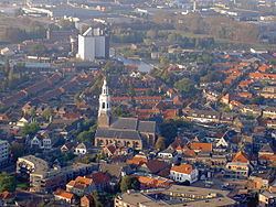
The city of Nijkerk
The name Nijkerk stems from Nieuwe Kerk (Dutch for New Church). This new church was built when the old chapel was destroyed by fire in 1221. Nijkerk was strategically located between the Duchy of Guelders (Dutch: Hertogdom Gelre) and the Bishopric of Utrecht. Because of this strategic location Nijkerk regularly was the scene of war, and in 1412 the village was completely destroyed. It was restored and Nijkerk received city rights in 1413. In 1421 the church that gave Nijkerk its name burnt down and was replaced; this happened several times, until a new church was built in the 18th century which still stands today. The organ in this church was built in 1756.
In the 18th century Nijkerk was a flourishing merchant city. Several inhabitants traveled to the New World, such as Arent van Curler and Kiliaen van Rensselaer and founded new cities.
Since World War II Nijkerk is growing fast. It lies on the (former) shore of the IJsselmeer which allows for transportation of goods via ships, and the proximity of two major motorways, the E30 (A1) and E232 (A28). This allowed local industries to grow, and also caused a lot of people who work in the nearby Randstad to move to the more quiet Nijkerk. Also the easy access to the Veluwe is a contributing factor to this growth.
Politics
In 2000, the municipalities of Nijkerk and Hoevelaken merged to form the new municipality of Nijkerk. Since then the city council has 25 seats. On August 24, 2011, the municipality announced that Nijkerk had passed the mark of 40,000 inhabitants. This should mean that after the next election the city council would be extended by 2 seats.
Currently (March, 2014) the seats are divided as follows:
Progressief 21 is a local party combining the local chapters of D66, GroenLinks and PvdA. The last two parties are local parties that have no national connection.