
Population 3,351 (2015) Area 48,113 km² Mayor Greg Campbell | Established 1884 Founded 1884 | |
 | ||
Points of interest Corella Dam, Overlanders Way, Clem Walton Park, Mary Kathleen Mine, Lake Julius | ||
The Shire of Cloncurry is a local government area in North West Queensland, Australia. It covers an area of 48,113.3 square kilometres (18,576.6 sq mi), and has existed as a local government entity since 1884. The major town and administrative centre of the shire is Cloncurry.
Contents
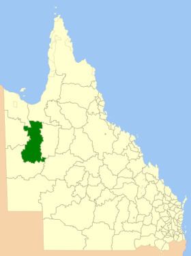
Map of Cloncurry, QLD, Australia
Prior to European settlement the area was home to the Mitakoodi, Kalkadoon and Pitta Pitta Aboriginal people.
The ghost town of Mary Kathleen, a town servicing a uranium mine since closed, is in the shire.
History
The Doonmunya Division was created on 11 November 1879 as one of 74 divisions around Queensland under the Divisional Boards Act 1879 with a population of 396. However, the divisional board appeared to be completely inactive, perhaps because the division was so large (being the area surrounding the southern part of the Gulf of Carpentaria) and was very sparsely settled. Nonetheless some of the citizens were unhappy about this. Consequently, on 11 January 1883, the Doonmunya Division was abolished and a new Carpentaria Division was created to replace it.
Given the size of the Carpentaria Division, the distance to its headquarters in Normanton was an issue for residents in the Cloncurry area, leading to a desire to create their own local division. On 7 February 1884, part of Carpentaria Division was separated to create the new Cloncurry Division.
On 30 January 1885, adjustments were made to boundaries of the Cloncurry Division when the Burke Division was also split off from the Carpentaria Division.
On 31 March 1903, Cloncurry Division became the Shire of Cloncurry.
Towns and localities
The Shire of Cloncurry includes the following settlements:
Chairmen and mayors
Other notable members of the council included: