
Highest point Round Top | ||
 | ||
Mountains | ||
Far eastern fells 2
The Far Eastern Fells are a group of hills in the English Lake District. Reaching their highest point at High Street (828 metres or 2,718 ft) they occupy a broad area to the east of Ullswater and Kirkstone Pass. Much quieter than the central areas of Lakeland they offer in general easier but less exciting walking as the fells merge mainly into the surrounding moorlands. Exceptions however are the fine rock scenery to be seen on Harter Fell, Mardale Ill Bell and High Street surrounding the head of Haweswater
Contents
- Far eastern fells 2
- Lake district the far eastern fells angletarn crags via high street to gray crag
- Partition of the Lakeland Fells
- Boundaries
- Topography
- Access for walkers
- References
Lake district the far eastern fells angletarn crags via high street to gray crag
Partition of the Lakeland Fells
The Lake District is a National Park in the north west of the country which, in addition to its lakes, contains a complex range of hills. These are locally known as fells and range from low hills to the highest ground in England. Hundreds of tops exist and many writers have attempted to draw up definitive lists. In doing so the compilers frequently divide the range into smaller areas to aid their description.
The most influential of all such authors was Alfred Wainwright whose Pictorial Guide to the Lakeland Fells series has sold in excess of 2 million copies, being in print continuously since the first volume was published in 1952. Wainwright divided the fells into seven geographical areas, each surrounded by valleys and low passes. While any such division must be arbitrary — and later writers have deviated to a greater or lesser extent from this blueprint — Wainwright's sevenfold division remains the best known partitioning of the fells into 'sub ranges', each with its own characteristics. The Far Eastern Fells are one of these divisions, covered by volume 2 of Wainwright's work.
Boundaries
The Far Eastern Fells occupy the region east of the A592 Kirkstone Pass road. This runs north from Ambleside to Patterdale at the head of Ullswater. The western perimeter then continues down the length of the lake to Pooley Bridge. Wainwright's outer boundary was more arbitrary since he chose not to mirror the edge of the National Park as he was "concerned only with the high ground". He determined instead upon straight lines connecting the outer limits of Ullswater and Haweswater, the proposed (and never built) Swindale Reservoir and Windermere. He extended this area slightly by stretching the boundary out to Longsleddale church, thus bringing in Tarn Crag and Grey Crag, the most easterly 2,000 footers. Wainwright thus excluded the high moorland falling eastward to the M6 Motorway, although later writers such as Birkett have included everything to the park boundary.
Topography
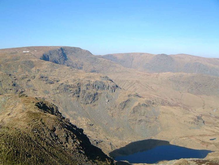
The higher section of the Far Eastern Fells can best be thought of as a part of the great horseshoe of fells surrounding the Ullswater catchment, continuing on from the main spine of the Eastern Fells on the other side of Kirkstone. First, directly above the Inn at the summit of the pass, is Stony Cove Pike, known to devotees of Wainwright by its alternative name of Caudale Moor. Swinging gradually northward the ridge continues over Thornthwaite Crag, High Street, Rampsgill Head and High Raise. The western, Ullswater, side of the ridge is characterised by the steep U-shaped valleys of Martindale running north to the lake, rough grass, heather and bracken being the principal terrain. On the eastern flanks are deep corries, sharp ridges and a great deal of exposed rock, looking down on the Haweswater Reservoir. North of High Raise the ridge descends gradually northward, gradually assuming a moorland character as it passes over Wether Hill and Loadpot Hill before petering out altogether near Pooley Bridge. Only above the shore of Ullswater does a trace of Lakeland remain, with the steep faces of Arthur's Pike and Bonscale Pike looming over the lake.
The complex valley system of Martindale lies on the western side of the main ridge, the dales divided by ridges which fan out from Rampsgill Head. Here the walker will find The Knott and Rest Dodd falling from the higher ground, beyond which are The Nab, Brock Crags and Beda Fell. Completing the group above Patterdale are Angletarn Pikes with its beautiful indented tarn and Place Fell. Steel Knotts and Hallin Fell also rise to the west of the main range, satellites of Wether Hill.
To the south of High Street is the long valley of Kentmere, blessed with fine ridges on either flank to make a splendid horseshoe walk. On the western side, flowing south from Thornthwaite Crag with the graceful curves of a roller-coaster are Ill Bell, Froswick and Yoke. To the east are Mardale Ill Bell, Harter Fell, Kentmere Pike and Shipman Knotts. Eastward again are the parallel valley of Longsleddale and the further ridge running from Branstree to Grey Crag.
Harter Fell turns its smoother back to Kentmere, saving its more impressive side for the head of Mardale, the valley holding Haweswater. Before the lake was raised by a dam in the 1930s the small village of Mardale Green stood at the head of the valley, now only revealed in time of drought. Feeding the lake from either side of Mardale Ill Bell are the corrie tarns of Small Water and Blea Water, the latter being the deepest tarn in Lakeland.
Access for walkers
Patterdale and Glenridding provide a good base to the north west, walks via Boredale Hause being possible along the ridges all the way to High Street. From Ambleside to the southwest the lower hills around Troutbeck are within easy reach. Martindale can be reached either by the Ullswater steamer or a long drive around the lake, Place Fell and Hallin Fell being particular favourites from this direction.
To the east of the group there are fewer facilities, particularly since the demise of habitation within Mardale. A car park has however been provided at the head of the lake which brings the great arc of fells from Branstree round to High Raise into range. Mardale Head is also the northern terminus of two important walkers’ passes, Nan Bield to Kentmere and Gatesgarth to Longsleddale. Both of these quiet valleys also allow car access part way along, although in the summer months an extended bus service is provided for walkers. Expeditions into the group via the extreme eastern valleys result in long walks over unfrequented moorland. The ridges surrounding Bannisdale, Crookdale, Wet Sleddale or Naddle Beck can be considered, although no other human is likely to be seen all day.