
OS grid NY427171 Elevation 509 m | Topo map OS Explorer OL5 Prominence 60 m | |
 | ||
Similar Angletarn Pikes, Rest Dodd, Hallin Fell, Steel Knotts, The Nab | ||
Lake district country walk martindale hause farm to beda fell round
Beda Fell is a fell in the English Lake District, situated to the south of Ullswater. It divides the valleys of Boredale and Bannerdale within the Martindale system.
Contents
- Lake district country walk martindale hause farm to beda fell round
- Map of Beda Fell Penrith UK
- Beda fell angletarn pikes
- TopographyEdit
- SummitEdit
- AscentsEdit
- References
Map of Beda Fell, Penrith, UK
Beda fell angletarn pikes
TopographyEdit
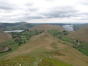
The southern boundary of the Martindale catchment is formed by a long ridge running from Rampsgill Head to Place Fell. Spurs run north from here to separate the individual valleys and Beda Fell is one of these. Starting from its parent fell of Angletarn Pikes, the spur runs north for around two and a half miles before dropping to valley level close to Sandwick. Part way along, Beda Fell broadens and rises to its summit, the top being named as Beda Head.
The top of the ridge is grassy, but the flanks are universally steep with considerable areas of crag. The western Boredale side is fairly straight, with Brock Crag below the summit and Low Brock Crag further north. The eastern flank bows outward around the summit area as the fell widens and then narrows again. Bannerdale runs below the southern slopes on this side, before merging with Rampsgill to form Howe Grain on the journey to Ullswater. Just north of the summit are Allen Crag, Ewe Crag, Raven Crag and Thrang Crag, falling in tiers from the ridge. Further on, above Howe Grain, are more rock faces at Nickles, Halstead Brow and Winter Crag.
Descending from Angletarn Pikes, Beda Fell begins as a series of rocky knolls on a narrowing ridge. The last of these is Bedafell Knott at 1,580 ft, after which grass generally prevails. A double depression at 1,460 ft is crossed before the ridge climbs to Beda Head, the summit of the fell. Passing north from here the ridge narrows dramatically between the crags and falls to the unenclosed road from Howtown to Sandwick, finally reaching valley level at the confluence of Howe Grain and Boredale.
SummitEdit
Beda Head is a grassy mound with a small cairn. There is a good view of the surrounding high fells, but the wideness of the ridge hides much of the neighbouringing valleys. Ullswater is visible, either side of Hallin Fell.
AscentsEdit
Beda Fell is easily climbed straight up the ridge from the road. This walk can also be started from a quarter mile up either Boredale or Howe Grain, a path traversing the fell just below the subsidiary summit topping Winter Crag. A good path continues southward from the summit to reach Angletarn Pikes. The ridge is also crossed near Bedafell Knott by a bridleway from Patterdale (via Boredale Hause) to the end of the bannerdale road at Dale Head Farm.
The best way up Beda Fell, which I love and have climbed many times. as have my wife and children, is to take the upper path at the back of Winter Crag Farm taking you northward through bracken to your first "summit" on the ridge, then start the delightful and rewarding walk southwards along and up the ridge to Beda Fell Knott. The option then is either descend the same way or walk on over Angle Tarn Pikes, enjoy the beautiful Angle Tarn, a lovely lake at 1600 feet, then descend southward to Patterdale where, if you have got your timing right, you can catch the steamer up the lake Ullswater back to Howtown from Glenridding.
We have found it safer to camp in Glenridding (Gill Side Farm), catch a morning steamer, have a quick coke and sandwich at The Howtown Hotel then do the walk. Tim Holt