
Location Pacific Ocean Coastline 6,000 m (20,000 ft) Population no civilian population Area 151 ha | Total islands 1 Highest elevation 9 m (30 ft) Elevation 9 m | |
 | ||
Similar Chichijima, Yonaguni, Ogasawara Islands, Hachijō‑jima, Banaba Island | ||
Tokyo japan collage video 13 youtube com tanvideo11
Minami-Tori-shima (南鳥島, "Southern Bird Island"), also known as Marcus Island, is an isolated Japanese coral atoll in the northwestern Pacific Ocean, located some 1,848 kilometres (1,148 mi) southeast of Tokyo and 1,267 kilometres (787 mi) east of the closest Japanese island, South Iwo Jima of the Ogasawara Islands, and nearly on a straight line between mainland Tokyo and the United States' Wake Island, 1,415 kilometres (879 mi) further to the east-southeast. The closest island to Minami-Tori-shima is East Island in the Mariana Islands, which is 1,015 kilometres (631 mi) to the west-southwest. The meaning of its Japanese name is "Southern Bird Island". It is the easternmost territory belonging to Japan, and the only Japanese territory on the Pacific Plate, past the Japan Trench. Although very small (just over 1 km2) and without a civilian population, it is of strategic importance, as it enables Japan to claim a 428,875 square kilometres (165,589.6 sq mi) Exclusive Economic Zone in the surrounding waters. It is also the easternmost territory of Tokyo, being administratively part of Ogasawara village.
Contents
- Tokyo japan collage video 13 youtube com tanvideo11
- Map of Minamitori Island Minamitorishima Ogasawara Tokyo 100 2100 Japan
- Geography
- History
- Minami Tori Shima area rare earth deposits
- Climate
- References
Map of Minamitori Island, Minamitorishima, Ogasawara, Tokyo 100-2100, Japan
Geography
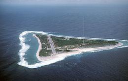
Minami-Tori-shima is triangular in shape, and unusual in that it has a saucer-like profile, with a raised outer rim of between 5 and 9 metres (16 and 30 ft) above sea level. The central area of the island is 1 metre (3 ft) below sea level. Minami-Tori-shima is surrounded by a fringing reef which ranges from 50 to 300 metres (164–984 ft) in width, enclosing a shallow lagoon, which is connected with the open ocean by narrow passages on the southern and northeastern sides. Outside the reef, the ocean depths quickly plunge to over 1,000 metres (3,300 ft). The island has a total land area of 1.2 square kilometres (300 acres). The island also has the highest average temperature in Japan.
History
The first discovery and mention of an island in this area was made by a Spanish Manila Galleon captain, Andrés de Arriola in 1694. It was charted in Spanish maps as Sebastian López, after the Spanish Admiral Sebastian López, victorious in the battles of La Naval de Manila in 1646 against the Dutch. Its exact location was left unrecorded until further sightings in the early 19th century.
The island was mentioned again in 1864 by the ship Morning Star, belonging either to the United States or the Kingdom of Hawaii, and was given the name "Marcus Island". Its position was recorded by a United States survey ship in 1874, and first landed on by a Japanese national, Kiozaemon Saito in 1879. On June 30, 1886, a Japanese named Shinroku Mizutani led a group of 46 colonists from Haha-jima in the Ogasawara Islands to settle on Marcus Island. The settlement was named "Mizutani" after the leader of the expedition. The Empire of Japan officially annexed the island July 24, 1898, the previous United States claim from 1889 according to the Guano Islands Act not being officially acknowledged. The island was officially named "Minami-Tori-shima" and placed administratively under the Ogasawara Subprefecture of Tokyo.
Sovereignty over the island before World War I was apparently disputed as various sources from the time move the island from the American to Japanese domain without specific explanation. In 1902, the United States dispatched a warship from Hawaii to enforce its claims, but withdrew on finding the island still inhabited by Japanese, with a Japanese warship patrolling nearby. In 1914, William D. Boyce included Marcus Island as an obviously American island in his book, The Colonies and Dependencies of the United States. In 1933, by orders of the Japanese government, the civilian inhabitants of Minami-Tori-shima were evacuated. In 1935, the Imperial Japanese Navy established a meteorological station on the island, and built an airstrip.
After the start of World War II the Japanese garrison stationed on the island consisted of the 742-man Minami-Tori-shima Guard Unit, under the command of Rear Admiral Masata Matsubara and the 2,005 man 12th Independent Mixed Regiment of the Imperial Japanese Army, under the command of Colonel Yoshiichi Sakata. The United States Navy bombed it repeatedly in 1942 and in 1943, but never attempted to capture it (the island was featured in the U.S. film The Fighting Lady). The island was taken by American forces on May 12, 1945. Though isolated, the Japanese were able to resupply the garrison by submarine, using a channel cut through the reef on the northwest side of the island. That channel is still visible today.
The Treaty of San Francisco transferred the island to American control.
The island was returned to Japanese control in 1968, but the Americans retained control of the airstrip and LORAN station.
In 1964, after some delays caused by storms that ravaged the island during construction, the U.S. Coast Guard opened a LORAN-C navigation station on Marcus Island, whose mast was until 1985 one of the tallest structures in the Pacific area. Before replacing Loran A for general marine navigation, Loran C was used by submarine launched Polaris missile systems and the existence and location of Loran C stations was classified. LORANSTA Marcus Island was billeted for 23 U.S. Coast Guard personnel. The commissioning commanding officer was Lieutenant General L. C. Snell. A detachment of SEABEES remained on the island for several months making repairs to the island's air strip.
The island is extremely isolated and Coast Guardsmen stationed on the island served one-year tours that were later modified to allow an R&R visit to mainland Japan at the six-month point. At the end of this isolated tour of duty crew members received an additional 30 days of compensatory leave. While under U.S. administration, on Thursdays a C-130 Hercules from the 345th Tactical Airlift Squadron, Yokota Air Base, Japan, would resupply the island on weekly missions. Often Coast Guardsmen would judge landings by raising placards with large numbers. An unusually long four-hour ground time was scheduled to allow technicians who flew in to perform maintenance on the transmitter and to offload extra fuel from the C-130 to power the island's generator. It also allowed the Coast Guardsmen to read and answer letters while aircrews would snorkel and collect green glass fishing buoys that wash up on the shore. It takes about 45 minutes to walk around the island.
The station was transferred from the U.S. Coast Guard to the Japan Maritime Self Defense Force (JMSDF) on September 30, 1993, and was closed on December 1, 2009.
The island is currently used for weather observation and has a radio station, but little else. Because of its isolation, it is of some interest to amateur radio hobbyists. The JMSDF garrison was supplied by C-130 from Iruma Air Base, or by C-130 from Haneda or Atsugi Air Base with flights via Iwo Jima on a weekly basis. The runway of Minami Torishima Airport is only 1,300 metres (4,300 ft) long and cannot handle larger aircraft. The island is considered as a separate country for amateur radio awards. The island is off-limits to civilians, except from the Japan Meteorological Agency.
Minami-Tori-Shima area rare earth deposits
In January 2013 a deep-sea research vessel of the Japan Agency for Marine-Earth Science and Technology obtained seven deep-sea mud core samples from the seafloor at 5,600 to 5,800 meters depth, approximately 250 kilometres (160 mi) south of the island. The research team found a mud layer 2 to 4 meters beneath the seabed that is extremely concentrated in rare earth oxides (REO). Analytical results showed that the maximum REO content in the mud was up to 0.66% REO. The deposit compares in grade with the ion-absorption-type deposits in southern China that provide the bulk of Chinese REO mine production, which grade in the range of 0.05% to 0.5% REO.
Climate
Minami-Tori-shima has a tropical savanna climate (Köppen climate classification Aw), with warm to hot temperatures throughout the year. The wettest months are July and August, while the driest months are February and March.