
Area 1,157 km² | Subdivisions 5 | |
 | ||
Points of interest National Museum of Military Hi, Vianden Castle, Bourscheid Castle, Clerve, Kneiff Destinations | ||
The District of Diekirch was one of three districts of the Grand Duchy of Luxembourg. At last, it contained five cantons divided into 43 communes:
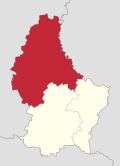
Map of Diekirch, Luxembourg
- Clervaux
- Clervaux
- Consthum
- Heinerscheid
- Hosingen
- Munshausen
- Troisvierges
- Weiswampach
- Wincrange
- Diekirch
- Bettendorf
- Bourscheid
- Diekirch
- Ermsdorf
- Erpeldange
- Ettelbruck
- Feulen
- Hoscheid
- Medernach
- Mertzig
- Reisdorf
- Schieren
- Redange
- Beckerich
- Ell
- Grosbous
- Préizerdaul
- Rambrouch
- Redange
- Saeul
- Useldange
- Vichten
- Wahl
- Vianden
- Putscheid
- Tandel
- Vianden
- Wiltz
- Boulaide
- Esch-sur-Sûre
- Eschweiler
- Goesdorf
- Heiderscheid
- Kiischpelt
- Lac de la Haute-Sûre
- Neunhausen
- Wiltz
- Winseler
It bordered Belgian's Walloon Region by the latter's provinces of Luxembourg in the west and Liège in the north, the districts of Luxembourg in the south and Grevenmacher in the south-east, and the German Land of Rhineland-Palatinate in the east. It had a per capita income of $49,000.
After the reorganization of Luxembourg's administrative divisions in 2015, all three districts were abolished per 3 October 2015.
References
Diekirch District Wikipedia(Text) CC BY-SA