
Area rank 9 of 105 Lowest elevation 284 m (932 ft) Area 48.5 km² Lau 2 05007 | Canton Wiltz Highest elevation 537 m (1,762 ft) Time zone CET (UTC+1) Local time Friday 8:45 PM | |
 | ||
Weather 6°C, Wind E at 5 km/h, 61% Humidity | ||
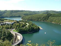
Lac de la Haute-Sûre (Luxembourgish: Stauséigemeng), (German: Stauseegemeinde) is a commune in north-western Luxembourg. It is part of the canton of Wiltz, which is part of the district of Diekirch. The commune is named after the Upper Sûre Lake, a reservoir on the upper Sauer river. The commune's administrative centre is Bavigne.
Map of Lac de la Haute-S%C3%BBre, Luxembourg
Lac de la Haute-Sûre was formed on 1 January 1979 from the former communes of Harlange and Mecher, both in Wiltz canton. The law creating Lac de la Haute-Sûre was passed on 23 December 1978.
Towns within the commune include Bavigne, Harlange, Mecher, Kaundorf, Nothum, and Tarchamps.
References
Lac de la Haute-Sûre Wikipedia(Text) CC BY-SA