
Area rank 36 of 105 Lowest elevation 232 m (761 ft) Area 23.92 km² Mayor Léon Bodem | Canton Redange Highest elevation 377 m (1,237 ft) Time zone CET (UTC+1) Local time Monday 6:33 AM Lau 2 03008 | |
 | ||
Weather 4°C, Wind N at 10 km/h, 99% Humidity | ||
Useldange (Luxembourgish: Useldeng, German: Useldingen) is a commune and small town in western Luxembourg, in the canton of Redange.
Map of Useldange, Luxembourg
As of 2005, the town of Useldange, which lies in the east of the commune, has a population of 622. Other towns within the commune include Everlange, Rippweiler, and Schandel.
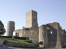
Useldange Castle is a medieval castle, which, while now being mainly in ruin, also comprises the current townhall. It is located in the centre of the village, right opposite to the town's church building. The site can be visited throughout the year with special arrangements for poorly sighted visitors.
Useldange also has an airfield used by gliders (49.768611°N 5.965556°E / 49.768611; 5.965556 (Useldange glider field)).
References
Useldange Wikipedia(Text) CC BY-SA