
Books Columbia Journals | Role Fur Trader Name David Thompson | |
 | ||
Children Fanny (1801), Samuel (1804), Emma (1806), John (1808), Joshuah (1811), Henry (1813), Charlotte (1815), Elizabeth (1817), William (1819), Thomas (1822), George (1824), Mary (1827), Eliza (1829) Parents Ann Thompson, David Thompson Similar People Charlotte Small, Joseph Tyrrell, Elliott Coues, David Thomson - 3rd Baron | ||
Occupation Explorer and Map Maker | ||
Uncharted territory david thompson on the columbia plateau
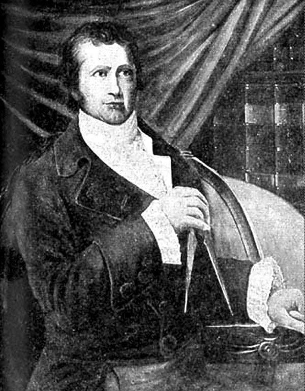
David Thompson (30 April 1770 – 10 February 1857) was a British-Canadian fur trader, surveyor, and map-maker, known to some native peoples as Koo-Koo-Sint or "the Stargazer." Over Thompson's career, he travelled some 90,000 kilometres (56,000 mi) across North America, mapping 4.9 million square kilometres (1.9 million square miles) of North America along the way. For this historic feat, Thompson has been described as the "greatest land geographer who ever lived."
Contents
- Uncharted territory david thompson on the columbia plateau
- Early life
- Hudsons Bay Company HBC
- North West Company
- Columbia River travels
- Appearance and personality
- Marriage and children
- Later years
- Death and afterward
- Works
- References
Early life

David Thompson was born in Westminster, Middlesex, to recent Welsh migrants David and Ann Thompson. When Thompson was two, his father died. Due to the financial hardship with his mother without resources, Thompson and his older brother were placed in the Grey Coat Hospital, a school for the disadvantaged of Westminster. Thompson graduated to the Grey Coat mathematical school, where he was introduced to basic navigation skills. He later built on these to make his career. In 1784, at the age of 14, he entered a seven-year apprenticeship with the Hudson's Bay Company. He set sail on 28 May of that year, and left England for North America.
Hudson's Bay Company (HBC)
Thompson arrived in Churchill (now in Manitoba) and was put to work as a clerk, copying the personal papers of the governor of Fort Churchill, Samuel Hearne. The next year he was transferred to nearby York Factory, and over the next few years spent time as a clerk at Cumberland House, Saskatchewan, and South Branch House before arriving at Manchester House in 1787. During those years he learned to keep accounts and other records, calculate values of goods and furs, track supplies and other duties.
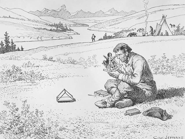
On 23 December 1788, Thompson seriously fractured his leg, forcing him to spend the next two winters at Cumberland House convalescing. It was during this time that he greatly refined and expanded his mathematical, astronomical, and surveying skills under the tutelage of Hudson's Bay Company surveyor Philip Turnor. It was also during this time that he lost sight in his right eye.
In 1790, with his apprenticeship nearing its end, Thompson requested a set of surveying tools in place of the typical parting gift of fine clothes offered by the company to those completing their indenture. He received both. He entered the employ of the Hudson's Bay Company as a fur trader. In 1792 he completed his first significant survey, mapping a route to Lake Athabasca (where today's Alberta/Saskatchewan border is located). In recognition of his map-making skills, the company promoted Thompson to surveyor in 1794. He continued working for the Hudson's Bay Company until 23 May 1797 when, frustrated with the Hudson's Bay Company's policies over promoting the use of alcohol with indigenous people in the fur trade, he left. He walked 130 kilometres (80 mi) in the snow in order to enter the employ of the competition, the North West Company. There he continued to work as a fur trader and surveyor.
North West Company
Thompson's decision to defect to the North West Company in 1797 without providing the customary one-year notice was not well received by his former employers. But the North West Company was more supportive of Thompson pursuing his interest in surveying and work on mapping the interior of what was to become Canada, as they judged it in the company's long-term interest. In 1797, Thompson was sent south by his employers to survey part of the Canada-US boundary along the water routes from Lake Superior to Lake of the Woods to satisfy unresolved questions of territory arising from the Jay Treaty between Great Britain and the United States after the American Revolutionary War.
By 1798 Thompson had completed a survey of 6,750 km (4,190 mi) from Grand Portage, through Lake Winnipeg, to the headwaters of the Assiniboine and Mississippi rivers, as well as two sides of Lake Superior. In 1798, the company sent him to Red Deer Lake (Lac La Biche in present-day Alberta) to establish a trading post. (The English translation of Lac la Biche: Red Deer Lake, was first recorded on the Mackenzie map of 1793.) Thompson spent the next few seasons trading based in Fort George (now in Alberta), and during this time led several expeditions into the Rocky Mountains.
In 1804, at the annual meeting of the North West Company in Kaministiquia, Thompson was made a full partner of the company. He spent the next few seasons based there managing the fur trading operations but still finding time to expand his surveys of the waterways around Lake Superior. At the 1806 company meeting, officers decided to send Thompson back out into the interior. Concern over the American-backed expedition of Lewis and Clark prompted the North West Company to charge Thompson with the task of finding a route to the Pacific to open up the lucrative trading territories of the Pacific Northwest.
Columbia River travels
After the general meeting in 1806, Thompson travelled to Rocky Mountain House and prepared for an expedition to follow the Columbia River to the Pacific. In June 1807 Thompson crossed the Rocky Mountains and spent the summer surveying the Columbia basin; he continued to survey the area over the next few seasons. Thompson mapped and established trading posts in Northwestern Montana, Idaho, Washington, and Western Canada. Trading posts he founded included Kootenae House, Kullyspell House and Saleesh House; the latter two were the first trading posts west of the Rockies in Idaho and Montana, respectively. These posts established by Thompson extended North West Company fur trading territory into the Columbia Basin drainage area. The maps he made of the Columbia River basin east of the Cascade Mountains were of such high quality and detail that they continued to be regarded as authoritative well into the mid-20th century.
In early 1810, Thompson was returning eastward toward Montreal but, while on route at Rainy Lake, received orders to return to the Rocky Mountains and establish a route to the mouth of the Columbia. The North West Company was responding to the plans of American John Jacob Astor to send a ship around the Americas to establish a fur trading post of the Pacific Fur Company on the Pacific Coast. During his return, Thompson was delayed by an angry group of Peigan natives at Howse Pass. He was ultimately forced to seek a new route across the Rocky Mountains and found one through the Athabasca Pass.
David Thompson was the first European to navigate the full length of the Columbia River. During Thompson's 1811 voyage down the Columbia River, he camped at the junction with the Snake River on 9 July 1811. There he erected a pole and a notice claiming the country for Great Britain and stating the intention of the North West Company to build a trading post at the site. This notice was found later that year by Astor company workers looking to establish an inland fur post, contributing to their selection of a more northerly site at Fort Okanogan. The North West Company established its post of Fort Nez Percés near the Snake River confluence several years later. Continuing down the Columbia, Thompson passed the barrier of The Dalles with much less difficulty than undergone by Lewis and Clark, as high water carried his boat over Celilo Falls and many of the rapids. On 14 July 1811, Thompson reached the partially constructed Fort Astoria at the mouth of the Columbia, arriving two months after the Pacific Fur Company's ship, the Tonquin.
Before returning upriver and across the mountains, Thompson hired Naukane, a Native Hawaiian Takane labourer brought to Fort Astoria by the Pacific Fur Company's ship Tonquin. Naukane, known as Coxe to Thompson, accompanied Thompson across the continent to Lake Superior before journeying on to England.
Thompson wintered at Saleesh House before beginning his final journey back to Montreal in 1812, where the North West Company was based.
In his published journals, Thompson recorded seeing large footprints near what is now Jasper, Alberta, in 1811. It has been suggested that these prints were similar to what has since been called the sasquatch. However, Thompson noted that these tracks showed "a small Nail at the end of each [toe]", and stated that these tracks "very much resembles a large Bear's Track".
Appearance and personality
In 1820, the English geologist, John Jeremiah Bigsby, attended a dinner party given by The Hon. William McGillivray at his home, Chateau St. Antoine, one of the early estates in Montreal's Golden Square Mile. He describes the party and some of the guests in his entertaining book The Shoe and Canoe, giving an excellent description of David Thompson:
I was well placed at table between one of the Miss McGillivray's and a singular-looking person of about fifty. He was plainly dressed, quiet, and observant. His figure was short and compact, and his black hair was worn long all round, and cut square, as if by one stroke of the shears, just above the eyebrows. His complexion was of the gardener's ruddy brown, while the expression of his deeply-furrowed features was friendly and intelligent, but his cut-short nose gave him an odd look. His speech betrayed the Welshman, although he left his native hills when very young. I might have been spared this description of Mr David Thompson by saying he greatly resembled Curran the Irish Orator...
I afterwards travelled much with him, and have now only to speak of him with great respect, or, I ought to say, with admiration... No living person possesses a tithe of his information respecting the Hudson's Bay countries... Never mind his Bunyan-like face and cropped hair; he has a very powerful mind, and a singular faculty of picture-making. He can create a wilderness and people it with warring savages, or climb the Rocky Mountains with you in a snow-storm, so clearly and palpably, that only shut your eyes and you hear the crack of the rifle, or feel the snow-flakes melt on your cheeks as he talks.
Marriage and children
On 10 June 1799 at Île-à-la-Crosse, Thompson married Charlotte Small, a thirteen-year-old Métis daughter of Scottish fur trader Patrick Small and a Cree mother. Their marriage was formalised three years later at the Scotch Presbyterian Church in Montreal on 30 October 1812. He and Charlotte had 13 children together; five of them were born before he left the fur trade. The family did not adjust easily to life in Eastern Canada; they lived in Montreal while he was traveling. Two of the children, John (aged 5) and Emma (aged 7), died of round worms, a common parasite. By the time of Thompson's death, the couple had been married 58 years, the longest marriage known in Canada pre-Confederation.
Later years
Upon his arrival back in Montreal, Thompson retired with a generous pension from the North West Company. He settled in nearby Terrebonne and worked on completing his great map, a summary of his lifetime of exploring and surveying the interior of North America. The map covered the wide area stretching from Lake Superior to the Pacific, and was given by Thompson to the North West Company. Thompson's 1814 map, his greatest achievement, was so accurate that 100 years later it was still the basis for many of the maps issued by the Canadian government. It now resides in the Archives of Ontario.
In 1815, Thompson moved his family to Williamstown, Upper Canada, and a few years later was employed to survey the newly established borders with the United States from Lake of the Woods to the Eastern Townships of Quebec, established by Treaty of Ghent after the War of 1812. In 1843 Thompson completed his atlas of the region from Hudson Bay to the Pacific Ocean.
Afterwards, Thompson returned to a life as a land owner, but soon financial misfortune would ruin him. By 1831 he was so deeply in debt he was forced to take up a position as a surveyor for the British American Land Company to provide for his family. His luck continued to worsen and he was forced to move in with his daughter and son-in-law in 1845. He began work on a manuscript chronicling his life exploring the continent, but this project was left unfinished when his sight failed him completely in 1851.
Death and afterward
The land mass mapped by Thompson amounted to 3.9 million square kilometres (1.5 million square miles) of wilderness (one-fifth of the continent). His contemporary, the great explorer Alexander Mackenzie, remarked that Thompson did more in ten months than he would have thought possible in two years.
Despite these significant achievements, Thompson died in Montreal in near obscurity on 10 February 1857, his accomplishments almost unrecognised. He never finished the book of his 28 years in the fur trade, based on his 77 field notebooks, before he died. In the 1890s geologist J.B. Tyrrell resurrected Thompson's notes and in 1916 published them as David Thompson's Narrative, as part of the General Series of the Champlain Society. Further editions and re-examinations of Thompson's life and works were published in 1962 by Richard Glover, in 1971 by Victor Hopwood, and in 2015 by William Moreau.
Thompson's body was interred in Montreal's Mount Royal Cemetery in an unmarked grave. It was not until 1926 that efforts by J.B. Tyrell and the Canadian Historical Society resulted in the placing of a tombstone to mark his grave.
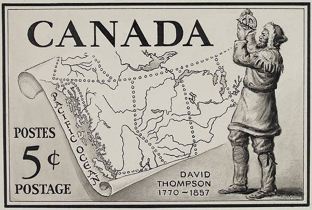
In 1957, one hundred years after his death, the Canadian government honoured him with his image on a Canadian postage stamp. The David Thompson Highway in Alberta was named in his honour, along with David Thompson High School situated on the side of the highway near Leslieville, Alberta. His prowess as a geographer is now well-recognized. He has been called "the greatest land geographer who ever lived."
There is a monument dedicated to David Thompson (maintained by the state of North Dakota) near the former town site of the ghost town, Verendrye, North Dakota, located approximately 2 miles (3.2 kilometres) north and 1 mile (1.6 kilometres) west of Karlsruhe, North Dakota. Thompson Falls, Montana and British Columbia's Thompson River are also named after the explorer.
The year 2007 marked the 150th year of Thompson's death and the 200th anniversary of his first crossing of the Rocky Mountains. Commemorative events and exhibits were planned across Canada and the United States from 2007 to 2011 as a celebration of his accomplishments.
In 2007, a commemorative plaque was placed on a wall at the Grey Coat Hospital, the school for the disadvantaged of Westminster David Thompson attended as a boy, by English author and TV presenter Ray Mears.
Thompson was the subject of a 1964 National Film Board of Canada short film David Thompson: The Great Mapmaker , as well as the BBC2 programme Ray Mears' Northern Wilderness (Episode 5), broadcast in November 2009.
He is referenced in the 1981 folk song "Northwest Passage" by Stan Rogers.