
Country Canada RCM Les Moulins Constituted June 27, 2001 Area 158.6 km² Province Québec | Region Lanaudière Settled 1673 Time zone EST (UTC−5) Population 106,322 (2011) Local time Wednesday 1:08 PM | |
 | ||
Weather 4°C, Wind NW at 14 km/h, 52% Humidity | ||
Terrebonne is an off-island suburb of Montreal, in western Quebec, Canada. It is located on the north shores of the Rivière des Mille-Îles and of the Rivière des Prairies, North of Montreal and Laval.
Contents
- Map of Terrebonne QC Canada
- History
- Infrastructure
- University
- CEGEP
- Vocational studies
- High school
- le des moulins
- Moulin Neuf dam
- Ecclesiastical architecture
- Sister cities
- Sports
- References
Map of Terrebonne, QC, Canada
This city is divided in three sectors, namely Lachenaie, La Plaine and Terrebonne. In the past, these sectors were distinct cities, but, on 22 August 2001, they merged under the name of Terrebonne. According to the 2011 Canadian Census Terrebonne has a population of 106,322, making it Montreal's fourth largest suburb.
History
The town of Lachenaie, which was founded in 1670 by Lord Charles Aubert de Lachenaye, is the oldest of the three towns that were merged. Some natives were already present on this territory at the time. The colonisation really started in 1647 when Lachenaie was merged with the Repentigny Seigniory. Louis Lepage de Ste-Claire, priest, canon, and the son of René Lepage de Sainte-Claire, acquired the Seigniory of Terrebonne on 2 September 1720. Abbot Louis Lepage de Ste-Claire built the first church in 1734 and the first manor in 1735. A few years later, Abbot Lepage equipped the town with both a saw mill and a flour mill.
The town of La Plaine was founded in 1830 on fragments of other towns, namely Mascouche, Sainte-Anne-des-Plaines, Saint-Lin, and Terrebonne. At that time, the lords of Terrebonne and Lachenaie built the road named "chemin de la Grande Ligne" to join the two towns. It is now called the boulevard Laurier. In 1877, the rail system was developed and stimulated the economic growth. The village of Saint-Joachim was founded during that time, which was later, in 1920, to be renamed La Plaine.
The first lord of Terrebonne was André Daulier-Deslandes, who was granted his title in 1673. Following the construction of the first wooden bridge in 1834, two main areas emerged. The commercial area was Terrebonne, while the agricultural one was Saint-Louis de Terrebonne. In 1985, these two cities merged.
At the time of the municipal merger in late August 2001, Lachenaie had over 20,000 residents, La Plaine had 17,000 residents, and Terrebonne had almost 46,000 residents. This merger made Terrebonne the 10th largest city in Quebec. Ten years later, the city had around 106,322 citizens on 154.6 km2 (59.7 sq mi) of land, according to the 2011 Canadian Census.
Infrastructure
Terrebonne is connected to Montreal's Central Station by commuter rail via the Terrebonne Station of the Agence métropolitaine de transport Mascouche Line.
The city of Terrebonne is also equipped with a bus network, namely Urbis, which enables residents to reach several metro stations both in Laval and Montreal, amongst many other locations. Some examples include bus line 30 (or 30G), which brings inhabitants of Terrebonne to the Radisson metro station on Sherbrooke Street East, bus line 19 (or 19G), which reaches Montmorency metro station in Laval, and bus line 25, whose terminal stop is at the Henri-Bourassa metro station.
University
The Université de Montréal has a small campus located near the Pierre Le Gardeur Hospital in the Lachenaie sector of the city of Terrebonne.
CEGEP
The Cégep régional de Lanaudière network has established a collegial institution, namely the Cégep régional de Lanaudière à Terrebonne, near Highway 640, in the Terrebonne sector of the city of Terrebonne.
Vocational studies
The city of Terrebonne counts several vocational education centers. The Centre de formation professionnelle des moulins is located next to the Cégep régional de Lanaudière à Terrebonne in the Terrebonne sector.
High school
French-language public schools in Terrebonne Ouest are operated by the Commission scolaire de la Seigneurie-des-Mille-Iles (CSSMI). Additionally, some schools within the city of Terrebonne are operated by the French Commission scolaire des Affluents and the English Sir Wilfrid Laurier School Board.
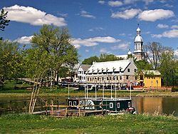
Île-des-moulins
The pre-industrial complex of the Île-des-moulins was amongst the most important ones in the province of Quebec during the 19th century. Although several infrastructures have degraded, a total of five buildings remain. The fourth lord of Terrebonne, Abbot Louis Lepage, had ordered the construction of the first flour mill in 1721 as well as the first saw mill around 1725.
In 1803, the bakery was built and established in the village. The actual saw and flour mills were built in 1804 and 1846, respectively. Four years following the construction of the flour mill that is currently standing at the Île-des-moulins to this day, the Moulin neuf (New Mill) was built in 1850. In addition, around the same time in 1850, the seigniory office was established.
In 1973, the Île-des-moulins was classified as a historic site of national interest by the Government of Quebec.
Moulin-Neuf dam
The Moulin-Neuf dam allows for the flow regulation of the Rivière des Mille Îles, as well as ice accumulation control in the spring.
The first dam at the Île-des-moulins was built in 1721, following the establishment of the very first flour mill. This dam linked the Île-des-moulins to the Ile Saint-Jean, passing through the small Île aux moutons, located midway between the two islands in the Rivière des Mille Îles.
In 1872, the Masson family ordered the construction of a new dam near the location of the current historical one. However, this dam was rebuilt in cement in the year 1890 for reinforcement and increased resilience.
Nearly a century later, in 1972, the owner of the Île-des-moulins decided to destroy the dam with dynamite due to flooding risk. As a result, the dam underwent severe damage, prompting the city of Terrebonne to acquire the island and classify it as a protected historical site in 1973.
In 1979, the Ministère des Richesses naturelles du Québec ordered the reconstruction of the Moulin-Neuf dam, to which a pedestrian walkway is added to allow citizens, visitors, and tourists to walk from the Île-des-moulins to the larger Ile Saint-Jean. This new dam was built a certain distance away from the small Île aux moutons, making the dam significantly longer than the initial ones.
Ecclesiastical architecture
The actual Saint-Louis-de-France Church in the Old Terrebonne (Vieux Terrebonne), near the historical site of the Île-des-moulins, was established in 1878, while the parish was founded in 1723 by Louis Lepage de Sainte-Claire, priest of the diocese of Quebec, parish priest of the Île Jésus, and lord of the Seigniory of Terrebonne. The parish was part of the diocese of Saint-Jérôme.
The current Saint-Louis-de-France Church built around the year 1878, the third since the foundation of the parish, was equipped with a Casavant organ in 1946.
In 1880, parish priest Piché, informally known as the bon monsieur Piché ("Good Mister Piché" in English), exhumed the bodies buried in the basement of the old church in order to place them in the crypt of the new one.
Sister cities
Sports
The Terrebonne Cobras are part of the QJHL.