
Airport type Public 13/31 4,300 Elevation 274 m | Owner City of Crookston Elevation AMSL 899 ft / 274 m Code CKN Phone +1 218-281-2625 | |
 | ||
Address 26305 Airport Road SW, Crookston, MN 56716, USA Similar University of Minnesot, Grand Forks Internatio, Crookston Inn, Thief River Falls Regional, AmericInn Lodge & Suites Cr | ||
Crookston Municipal Airport (IATA: CKN, ICAO: KCKN, FAA LID: CKN), also known as Kirkwood Field, is a city owned public use airport located four nautical miles (7 km) north of the central business district of Crookston, a city in Polk County, Minnesota, United States.
Contents
History
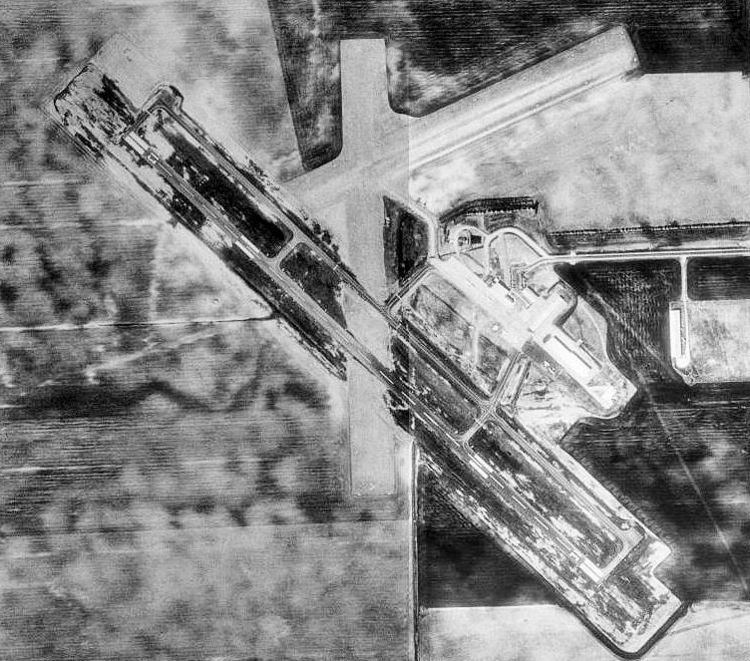
Provided contract glider training to the United States Army Air Forces, 1942-1944. Training provided by L. Millar-Wittig. Had turf 5,000' all-way airfield for landings and takeoffs. Used primarily C-47 Skytrains and Waco CG-4 unpowered Gliders. The mission of the school was to train glider pilot students in proficiency in operation of gliders in various types of towed and soaring flight, both day and night, and in servicing of gliders in the field.
Facilities and aircraft
Crookston Municipal Airport covers an area of 633 acres (256 ha) at an elevation of 899 feet (274 m) above mean sea level. It has three runways: 13/31 is 4,300 by 75 feet (1,311 x 23 m) with an asphalt surface; 17/35 is 2,977 by 202 feet (907 x 62 m) with an turf surface; 6/24 is 2,096 by 202 feet (639 x 62 m) with a turf surface.
For the 12-month period ending August 31, 2006, the airport had 20,150 aircraft operations, an average of 55 per day: 94% general aviation, 5% air taxi and <1% military. At that time there were 38 aircraft based at this airport: 97% single-engine and 3% multi-engine.