
Prominence 95 ft (29 m) | Topo map USGS Shullsburg | |
 | ||
Elevation 1,235 ft (376 m) NAVD 88 Listing U.S. state high points 45th Similar Ebright Azimuth, Campbell Hill, Jerimoth Hill, Mount Arvon, White Butte | ||
Charles mound illinois highpoint
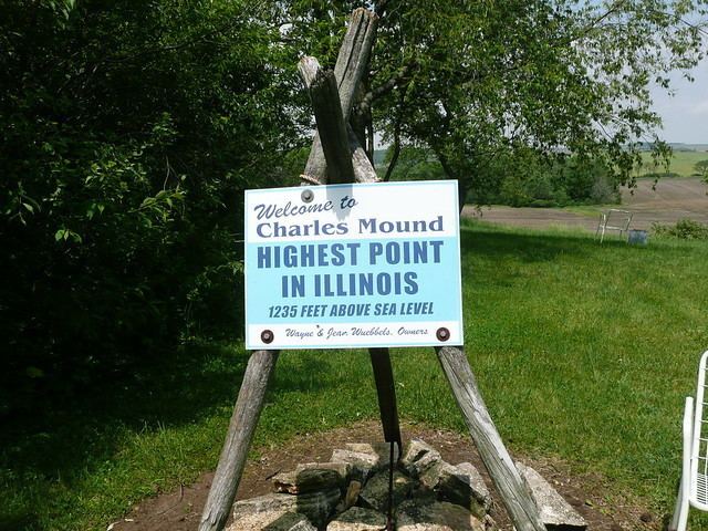
Charles Mound is a gentle, 1,235-foot (376 m) high hill in northern Jo Daviess County, Illinois, near the small town of Scales Mound and 11 miles (18 km) northeast of Galena. It is the highest natural point in the state; thus, it is considered a highpoint.
Contents
- Charles mound illinois highpoint
- Map of Charles Mound Scales Mound Township IL 61075 USA
- Charles mound illinois
- GeographyEdit
- SettlementEdit
- AccessEdit
- References
Map of Charles Mound, Scales Mound Township, IL 61075, USA
Charles mound illinois
GeographyEdit
Charles Mound is the highest natural point in Illinois. (The highest point is the Willis Tower, formerly known as the Sears Tower.) The top of the hill is about 0.25 miles (400 m) from the Wisconsin border. It is within the Driftless Area, a region of Illinois, Iowa, Minnesota, and Wisconsin that was not covered or ground down by the last continental glaciers. The hill itself is an erosional remnant, similar to that on which the original village site of Scales Mound was located.
SettlementEdit
Elijah Charles, one of the region's first permanent settlers, arrived in 1828 and settled at the base of the mound and the hill assumed his name.
AccessEdit
Charles Mound is located on rolling farmland. The land owners, Jean and Wayne Wuebbels, allow public access only on the respective first full weekends of the months of June, July, August, and September.